CG Trader
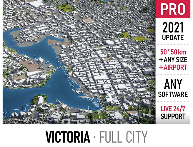
Victoria
by CG Trader
Last crawled date: 1 year, 10 months ago
This is exact and accurate to scale 3D city model of Victoria, Canada and its surrounding area based on GIS data (March 2021) File units: Meters Scale: 1:1 PACKAGE CONTENTS Fully customizable - you can select only the options you need! This product includes scenes of various sizes / formats Complete scene (city and surrounding area) Full city extents, downtown or airport Any custom area size (please request before buying) FORMATS INCLUDED MAX - Autodesk 3dsMax FBX, OBJ, DAE - Exchange Formats GLTF, GLB - Games, Web, AR/VR (request) UNITYPACKAGE - Unity 3D 3DM - Rhino 3D SKP - SketchUp RVT - Autodesk Revit (request) STL - 3D Print (request) C4D - Cinema4D BLEND - Blender MA, MB - Autodesk Maya DWG, DXF - Autodesk AutoCAD PRODUCT INFO KEY BENEFITS Regular updates and improvements! Live 24/7 support (custom requests, adjustments and updates) Buildings, landuse areas, roads and railways split by type (see scene structure) The surface is flat, easy to add details and edit geometry (terrain on request*) Realistic low-poly trees and forests (max, fbx included, other formats on request*) Product is ready to render out-of-the-box (3dsmax + corona renderer) TOPOGRAPHY TERRAIN (custom price, please request before buying) Up to 5 meters accuracy raw terrain object (2001-2015 LiDAR survey / USGS 3D Elevation Program) Multiple LODs optimized to achieve perfect polycount/details balance High-resolution (up to 64000x64000px) sattelite or surface texture Buildings and roads placed on the optimized terrain OTHER EXTRAS (custom price, please request before buying) Crop to custom area size or slice to tiles Procedural textures assigned to all buildings Individual buildings and streets (with address and/or name) Any coordinate system (Transverse Mercator projection by defaut) Administrative boundaries of all levels (named polygons or outlines) Road and railway splines for traffic animation Public transport stops with names PRESENTATION IMAGES 4K high-resolution realistic renderings (refer to images for level of detail) Rendered in 3dsMax (other softwares requires its own rendering settings) MATERIALS Buildings are UVW mapped, split by material IDs, no textures assigned Trees, vegetation, landuse and airport surface with the textures assigned SCENE STRUCTURE (layers / named objects split by type) BUILDINGS residential commercial industrial public sports parkings transport ROADS highways primary secondary tertiary residential service RAILWAYS train city tram subway monorail PAVEMENT sidewalk footway cycleway LANDUSE residential public industrial construction agriculture VEGETATION forest grass scrub park garden cemetery recreation NATURAL land sea lake river AIRPORT building (terminal, gates) apron taxiway runway CONTACT US - please send a message 24/7 All custom options and adjustments must be requested before purchase Product update with the latest GIS data - FREE Topography terrain add-on - FROM $299 city map model area building center skyline landscape topography suburb neighborhood downtown airport extents urban street park sketchup victoria canada exterior cityscape street exterior city street city building city landscape city map city skyline city street
Similar models
cg_trader
$299

Coquitlam
...reet park vancouver exterior cityscape street exterior city street city building city landscape city map city skyline city street
cg_trader
$399

San Jose - Costa Rica
...extents street park sketchup exterior cityscape street exterior city street city building city landscape city skyline city street
cg_trader
$299

Lipetsk
...chup lipetsk russia exterior cityscape street exterior city street city building city landscape city map city skyline city street
cg_trader
$299

Vladivostok - city and surroundings
...sketchup exterior cityscape street exterior city street city building city landscape city map city scene city street street scene
cg_trader
$299

Samara - city and surroundings
...sketchup exterior cityscape street exterior city street city building city landscape city map city scene city street street scene
cg_trader
$299

Hamilton - Ontario
...lton ontario canada exterior cityscape street exterior city street city building city landscape city map city skyline city street
cg_trader
$299

Aarhus
...odel topography suburb sketchup exterior cityscape city building city landscape city map city scene exterior house house exterior
cg_trader
$299

Omsk - city and surroundings
...t exterior city street city building city landscape city map city scene city skyline city street industrial building street scene
cg_trader
$299

Ankara
...hino exterior cityscape street exterior city street city building city landscape city map city skyline city street rhino building
cg_trader
$299

Novosibirsk - city and surroundings
...rior cityscape street exterior city street city building city landscape city map city scene city skyline city street street scene
Victoria
3ddd
$1
Victoria
...азмер: 1700 x 830 x 610 мм
h = 730, 680 мм
объём: 225 л
ссылкаhttp://paa.com.ua/ru/produkciya/victoria
3ddd
$1
Кресло Victoria A
...кресло victoria a
3ddd
victoria a , кресло
victoria a
3ddd
free
Victoria B
...victoria b
3ddd
victoria , кресло
victoria b
3ddd
$1
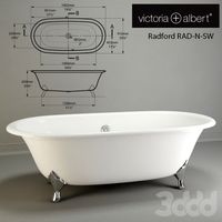
victoria+albert
...victoria+albert
3ddd
victoria+albert , ванна
victoria+albert
design_connected
$20

Victoria
...victoria
designconnected
zanotta victoria 2-seater computer generated 3d model. designed by n/a.
3ddd
free

Дятьково (Victoria)
... дятьково , стенка
комплект мебели дятьково гостиная victoria
3ddd
$1
Victoria
...victoria из каталога итальянской мебели grande arredo. текстуры в архиве, материалы v-ray, гамма 2.2, используется color correct.
3ddd
$1
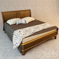
Кровать Victoria
...ть victoria
3ddd
victoria , grange
кровать victoria фабрики grange, коллекция 2012 года.
3ddd
$1

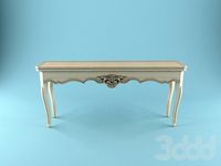
victoria desk
...victoria desk
3ddd
консоль
victoria desk
3ddd
$1

Roca-Victoria
...roca-victoria
3ddd
roca-victoria
умывальник roca-victoria с краном и тумбой в современном стиле.