Thingiverse
Vancouver - British Columbia - 3D Map - Topographic by ProteanMan
by Thingiverse
Last crawled date: 3 years ago
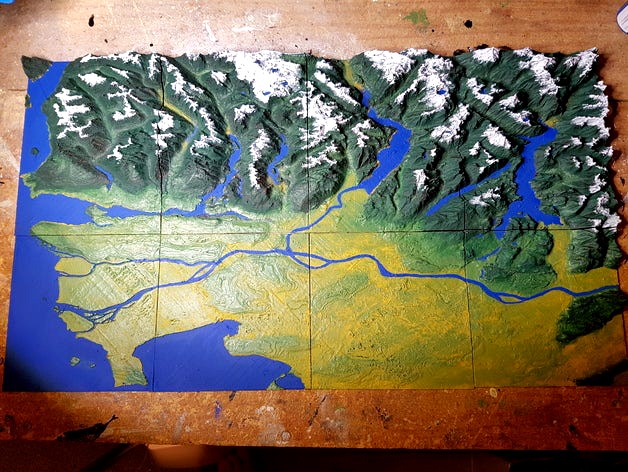
This is a 3D Topographical Map of Vancouver, British Columbia, Canada.
Taken from Google Maps data.
It is sized into 16 sections and should fit perfectly onto most 3D printers.
You can easily just scale it down or up depending on your printer. Just make sure that you remember the scale you use when slicing each section.
The images of the printed/painted map are of pieces 1 to 8. Pieces 9 to 16 go directly North (Up) from the painted map.
Order = Left to Right (1-4) and consecutively in the same order above (5-8, etc.)
[13-14-15-16]
[9 - 10-11-12]
[5 - 6 - 7 - 8 ]
[1 - 2 - 3 - 4 ]
Project Name: 3D Topographical Map of Vancouver and the Coastal Mountains
Overview & Background: I live in Vancouver and love every part of it. When people talk about this area they always speak of the mountains and terrain, but really only have post-cards and FLAT maps to look at. This shows how vertical everything is around the city. With the ocean being the lowest parts of the map.
Objectives: Students will get a birds eye view of the area. Seeing and FEELING the differences in terrain height. It's important to know where the flooding areas are and why they flood based on their height. This city and area is known for it's terrain, yet you have to travel very far and into difficult (impossible) areas to see it all. Better than just a computer screen, we can see everything with a full 3D ability.
Audiences: All ages can appreciate it to different degrees. The primary audience is grades 5 and up - based on common Geography lessons.
Subjects: Geography, Sciences (Earth Science), Art - for creating and painting the map.
Skills Learned (Standards): Precision printing, or the pieces will not fit together properly. Possible wood working for mounting the map plates, and painting the map if wanted.
Lesson/Activity: Depending on which parts of the map you would like - print out in PLA for the least number of issues with warping. Since it is a very flat and large base on each piece, PLA will not warp like ABS. Number each piece on the back with a marker to ensure that you do not mix them up, with an arrow showing North or a similar direction for all pieces. The pieces can be mounted with glue to a wall, board, or anything you would like. Another option is to have the pieces kept loose and put together when needed for geography lessons. When discussing the Vancouver and Coastal Mountains, or tectonic plate shifting, or other topics you can use this map.
Duration: Each plate can take from 1 to 4+ hours based on the height of the plate and size of printing scale.
Preparation: You need to have access to or have a 3D printer. There are websites that offer printing services as well, and will ship the pieces to you. Once the pieces are created how they are mounted (or not) is up to you. The rest of the preparation is determined whether the pieces are loose or mounted.
References: google.maps topographical data was used in creating these .stl files.
Rubric & Assessment: Geography - students will have discussed how geography of the Vancouver and local areas has affected the region with: commerce, water level changes, weather, and any other topics that the instructor finds relevant. Students will then use the map to locate where various aspects discussed in the lesson take place, name regions, and other points of interest.
MakerEdChallenge2
ScienceProject
ArtProject
DesignProject
Check out my Youtube channelhttps://www.youtube.com/channel/UCZ64RaAsrJ9v66Rt3bDEO2w
Check out my Websitehttp://proteanman.com
Follow me on Twitterhttps://twitter.com/Protean_Man
Enjoy!
Similar models
thingiverse
free

Flood Model by MobileMakerSpaceCapeCod
... give students absorbent materials to build a flood barrier and then use the printed model to test the effectiveness of the plan.
3dwarehouse
free

LQS Eco area terrain
...lqs eco area terrain
3dwarehouse
topographical map of school nature area.
cg_trader
$30

Topographical map of North America with borders | 3D
... borders mountain terrain 3dprint geography geoscience dem elevation canada mexico eductional accesible blind science engineering
3dwarehouse
free

my sentence about tectonic plates
... collide when 2 continental plates converge they push up the crust between and make mountains #geography#sentence#tectonic plates
cg_trader
$9

Terrain canyon
...ape stone sand gravel snow valley river flood plain hill geography geology layers exterior rock stone mountain snow mountain rock
cg_trader
$10

cartoon map - error marker - topographic map
...sure marked point topographic marked point topographic geography stylized hand painted cartoon lowpolymodel paper old sports book
thingiverse
free

3D Print a Topographic Map by mfritz
...c maps in 3d. for example, pushing the contour edges together to make a steep slope, or moving them apart to make a gentle slope.
cults
$2

3D Map - Mount Fuji, Japan
...o be painted.
it's unbelievable the powerful of learning, ideas creation when a model like this is available to be touched.
cg_trader
$8

Mountains desert
...e sand gravel snow valley river flood plain hill geography geology layers mineral exterior rock stone mountain snow mountain rock
thingiverse
free

Coastal Flooding Design Project by mfritz
...nts then used tinkercad to design and print a structure that would be helpful in a flood situation.
one student example is shown.
Proteanman
thingiverse
free

GoPro Tripod Mount (Targus) by ProteanMan
...erent brands of tripod. there is a clip at the back of the tripod attaches to this insert.
this was designed for a targus tripod.
thingiverse
free

Ukulele Wall Mount by ProteanMan
... tear.
check out my vlog and 3d printing videos on youtube - protean manhttps://www.youtube.com/channel/ucz64raasrj9v66rt3bdeo2w
thingiverse
free

Instrument Mustaches by ProteanMan
...n for some of them since the clips may break with pla. i haven't tried pla so let me know if they are strong enough with pla?
thingiverse
free

Dreadnought Fidget Spinner by ProteanMan
... of the spinner. be careful not to get glue on the bearing.
7-clamp the handles together to that they are straight, then let dry.
thingiverse
free

Whiteboard Pen Holder X5 by ProteanMan
...that if your printer prints with a larger tolerance around tight fitting parts then you will need to drill or sand out the holes.
thingiverse
free

Proteus Headphone Stand by ProteanMan
...back face. if you have amazing bridging capabilities on your printer then you can print it on the bottom face.
print, use, enjoy!
thingiverse
free

Proteus Cable Roller by ProteanMan
...way that does not earn you monetary value.
if you do wish to sell these products please let me know and we can come an agreement.
thingiverse
free
Box Making Parts by ProteanMan
...way that does not earn you monetary value.
if you do wish to sell these products please let me know and we can come an agreement.
thingiverse
free

Proteus Key Holder by ProteanMan
...d. this should work perfectly for any printer.
try using high infill - 50% or above when printing.
any ideas let me know. enjoy!
thingiverse
free

Custom Speaker Cover Plates by ProteanMan
...e option and type in 0.796. this resizes the file to the right size for my speaker.
now you have a perfectly sized speaker cover!
Topographic
3d_export
$25

Topographic map
...topographic map
3dexport
simple rendering of the scene file
3ddd
free
The topograph chandelier by Karim Rashid
... от карима рашида.
the topograph chandelier by karim rashid.http://www.karimrashid.com/projects#category_4/project_247
3d_export
$25
scale relief topographic world map
...ve also added the renderings both with and without texture, so that you will notice that it is done in detail.<br>enjoy it.
3d_export
$50
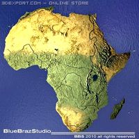
Africa 3D Model
...3dexport africa map terrain elevation satellite landscape mountain land topographic dem africa 3d model braz 21501...
3d_export
$50
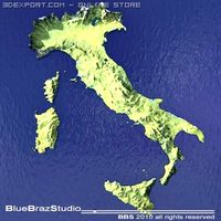
Italy 3D Model
...3dexport italy map terrain elevation satellite landscape mountain land topographic dem italy 3d model braz 21511...
3d_export
$50
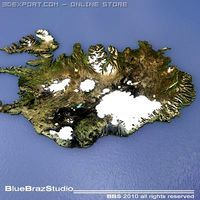
Iceland 3D Model
...3dexport iceland map terrain elevation satellite landscape mountain land topographic dem iceland 3d model braz 21509...
3d_export
$50
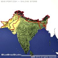
India 3D Model
...3dexport india map terrain elevation satellite landscape mountain land topographic dem india 3d model braz 21510...
3d_export
$50
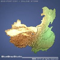
China 3D Model
...3dexport china imap terrain elevation satellite landscape mountain land topographic dem china 3d model braz 21505...
3d_export
$50
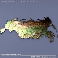
Russia 3D Model
...3dexport russia map terrain elevation satellite landscape mountain land topographic dem russia 3d model braz 21513...
3d_export
$50
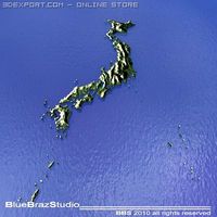
Japan 3D Model
...3dexport japan imap terrain elevation satellite landscape mountain land topographic dem japan 3d model braz 21508...
Columbia
3d_export
$17

columbia knifle
...columbia knifle
3dexport
columbia knifle
3ddd
$1

Sports bag Columbia
...dd
сумка , спорт , columbia
sports bag columbia
3ddd
free

Maries corner Columbia
...ries , corner , columbia
maries corner columbia
3ddd
free

Ванна акриловая Riho Columbia
... ванна
ванна акриловая riho columbia
дхшхв - 1400х700х470 мм
объём: 157 л
страна производителя: нидерланды
3ddd
free

Visionnaire Ipe Cavalli / Columbia
...e ipe cavalli / columbia
3ddd
ipe cavalli , visionnaire
visionnaire ipe cavalli columbia
cg_studio
$12

Columbia Logo3d model
...3ds .c4d .fbx .lwo .max .mb .obj .xsi - columbia logo 3d model, royalty free license available, instant download after purchase.
3ddd
$1

Магистральный тягач Freightliner Columbia
...вик , автомобиль
магистральный тягач freightliner columbia.
в архиве файл max 2012, obj.
3d_export
$49

Columbia Metropolitan Airport 10km
...columbia metropolitan airport 10km
3dexport
turbosquid
$199

COLUMBIA CITY NEWYORK 3D MODEL
... city newyork 3d model for download as 3ds, obj, c4d, and fbx on turbosquid: 3d models for games, architecture, videos. (1397444)
turbosquid
$180

Freightliner Columbia with Single expandable trailer
... available on turbo squid, the world's leading provider of digital 3d models for visualization, films, television, and games.
British
3d_ocean
$9

British Clock
...british clock
3docean
british clock interior
quality model british clock for your interior.
3d_export
$6
british car
...british car
3dexport
british car
3ddd
$1

British flag
...british flag
3ddd
флаг
british flag
3d_ocean
$5

Decorative british box
...decorative british box
3docean
box british decorative
decorative. quality model british box
turbosquid
$10
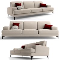
British sofa
...squid
royalty free 3d model british sofa for download as max on turbosquid: 3d models for games, architecture, videos. (1435097)
turbosquid
$5
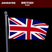
British Flag
...squid
royalty free 3d model british flag for download as max on turbosquid: 3d models for games, architecture, videos. (1332182)
3ddd
$1
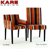
Kare Very British
...
szerokość (cm):54
wysokość (cm):79
głębokość (cm):59
econo very british
szerokość (cm):49
wysokość (cm):99
głębokość (cm):58
3ddd
$1

British Collection
... чашка
british collection.
в наборе: кресло, две подушки, картина, чашка.
3ds max 2011,2014,obj + textures
turbosquid
$30
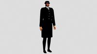
British Policewoman
... available on turbo squid, the world's leading provider of digital 3d models for visualization, films, television, and games.
turbosquid
$15

British Guitar
... available on turbo squid, the world's leading provider of digital 3d models for visualization, films, television, and games.
Vancouver
3d_export
$6

Vancouver 3D Model
...xport
canada 2010 olympic games logo vancouver olympics 4d 3ds winter olympiad wireframe
vancouver 3d model benq72 22789 3dexport
3ddd
$1

люстра vancouver vision
... art lamps , vancouver vision
модерновая кованная люстра. без текстур, всё процедуры :-)
3ddd
$1

vancouver vision настенный светильник (бра)
...ый светильник (бра)
3ddd
vancouver vision
кованное бра из серии vancouver vision. без текстур, но с процедурными материалами. 8-)
3d_export
$5

td tower in vancouver
...ions and etc. - clean edge-loops based topology - 3ds max 2018 or higher compatible<br>formats :<br>3ds max -fbx -obj
3d_export
$5

bc-place vancouver
...017 or higher compatible<br>formats :<br>3ds max -fbx -obj<br>if you need another format, be sure to contact me
3d_export
$199

vancouver city canada 40km
...t;1. suitable for games, games, education, architecture etc.<br>2. mainly used for town and urban planning, real estate etc
digiprops
$12

Yellow parking post (bollard)
...digiprops yellow parking post (bollard), chipped and rusty.photoscanned in vancouver ...
digiprops
$6

Utility access panel
...access panel built into a gray wall. photoscanned in vancouver ...
digiprops
$12

Yellow concrete parking block
...a couple of round holes. freshly painted. photoscanned in vancouver ...
digiprops
$18

Red fire hydrant
...licensing details, please see the pricing page. photoscanned in vancouver ...
Map
3d_ocean
$5

Map
...map
3docean
geography map ocean travel world world map
a world map
3d_ocean
$5

Old Map
...old map
3docean
dirty map ocean old map paper pirates rotten travel world map
an old map
turbosquid
$3

Map
... available on turbo squid, the world's leading provider of digital 3d models for visualization, films, television, and games.
3d_ocean
$3

Map of Iran
...map of iran
3docean
flag iran map outline
an outline map of iran
3d_ocean
$2

Map of the USA
...map of the usa
3docean
america flag globe map united states usa
an outline map of the usa
3ddd
$1

Abstract Maps
... город , picture
abstract maps by artist jazzberry blue
3d_ocean
$5

Honduras Map
...honduras map
3docean
3d cinema4d honduras map mapa
honduras map designed in cinema 4d r17
3d_ocean
$2

Map of Germany
...map of germany
3docean
black country europe germany gold map outline red yellow
a simple outline map of germany
3d_ocean
$2

Map of Australia
...map of australia
3docean
australia banner country down under earth flag globe map ocean south
an outline map of australia
3d_ocean
$2

Map of Russia
...of russia
3docean
asia banner earth europe flag globe map russia russian federation siberia sovjet union
an outline map of russia