Cults

Topographic map of Grand Teton, Wyoming
by Cults
Last crawled date: 6 years, 2 months ago
The **Grand Teton National Park** is dominated by **Teton Range**, an incredible mountain chain that rises abruptly. The three main summits of this chain are represented in this topographic map: **Grand Teton**, **Middle Teton** and **South Teton**.
The name Grand Teton is French. This is explained by its origin: **French trappers** who gave it that name. In search of beaver pelts they discovered this area in the 18th century. At the sight of the three highest snow-capped peaks, they thought of the shape of the feminine nipples ("tetons" in French).
The name Grand Teton is French. This is explained by its origin: **French trappers** who gave it that name. In search of beaver pelts they discovered this area in the 18th century. At the sight of the three highest snow-capped peaks, they thought of the shape of the feminine nipples ("tetons" in French).
Similar models
thingiverse
free

Grand Teton by Jcoltrane
...the surrounding peaks of the teton range in western wyoming.
created using thatcher chamberlin's awesome tool, terrain2stl.
thingiverse
free

Grand Tetons Topographical Map by iqless
...e are two different maps of the grand tetons.
more details can be found out about how i made them at https://youtu.be/g4cx0hrejgw
3dwarehouse
free

Grand Teton Perspective
...grand teton perspective
3dwarehouse
cg_trader
$55

3D Topographical Grand Canyon
...3d topographical grand canyon
cg trader
this is a 3d topographical model of grand canyon, created using blender 2.83 beta
thingiverse
free

Grand Canyon by Synergist
...grand canyon by synergist
thingiverse
i created this in the topographic app for windows from bing maps elevation data.
3dwarehouse
free

Moulton Barn
...moulton barn
3dwarehouse
barn near grand teton mountains
thingiverse
free

Canyon Topographical 3D Object by hpucismjrbb85
...canyon topographical 3d object by hpucismjrbb85
thingiverse
topographical region of grand canyon....
3dwarehouse
free

grand teton plaza
...-ann fabrics. it is located right next to the grand teton mall. #ammon #best_buy #grand_teton_plaza #idaho #idaho_falls #petsmart
thingiverse
free

Topographic Mozambique by Waynan
...topographic mozambique by waynan
thingiverse
topographic map of mozambique.
thingiverse
free

Topographic Botswana by Waynan
...topographic botswana by waynan
thingiverse
topographic map of botswana
Teton
3d_ocean
$25

Teton National Park
...w spectacular terrain teton
high detailed high polygon textured part from the teton national park. texture size 8192*8192 pixels.
3ddd
$1

Кухня Elite фабрики Cesar
...d100s,cristadur avorio-92. смеситель schock piega 547120,cristadur avorio-92. столешница samsungradians teton beige te215. духовки и варочной поверхности в файле нет....
thingiverse
free

Teton Range by pixelstacker
...teton range by pixelstacker
thingiverse
central teton range
thingiverse
free
Grand Teton by Jcoltrane
...the surrounding peaks of the teton range in western wyoming.
created using thatcher chamberlin's awesome tool, terrain2stl.
thingiverse
free

Latrax teton arm
...latrax teton arm
thingiverse
latrax teton 1/18 scale r/c car control arm, simple design but works great
thingiverse
free

Battery holder for Teton by taiofwind
...tery holder for teton by taiofwind
thingiverse
holder for using li-po battery in teton.
you can also use conventional batteries.
thingiverse
free

traxxas teton suspension arm by propbreakerK
...traxxas teton suspension arm by propbreakerk
thingiverse
la trax teton suspension arm stl file.
thingiverse
free

Teton Mountains by da429boss
...grand teton national park(imagery from the usgs 3dep program). used qgis demto3d tool to create the 3d model and sliced in cura.
thingiverse
free

latrax teton front body mount by dylanhirano5
...latrax teton front body mount by dylanhirano5
thingiverse
front body mount for latrax teton
thingiverse
free

snowboarding - Teton Gravity research by ns17817
...y ns17817
thingiverse
teton gravity resaerch. this was printed at 0.8 shell thickness so as you can see it needs to be increased
Wyoming
turbosquid
$15

Wyoming
... available on turbo squid, the world's leading provider of digital 3d models for visualization, films, television, and games.
turbosquid
$56

Wyoming counties
... available on turbo squid, the world's leading provider of digital 3d models for visualization, films, television, and games.
turbosquid
$40

Wyoming Political Map
...model wyoming political map for download as 3ds, max, and obj on turbosquid: 3d models for games, architecture, videos. (1302751)
turbosquid
$19

County Map - Wyoming
... available on turbo squid, the world's leading provider of digital 3d models for visualization, films, television, and games.
turbosquid
$20

Wyoming detailed Map with Animated Flag
... detailed map with animated flag for download as max and fbx on turbosquid: 3d models for games, architecture, videos. (1703781)
3d_export
$15

Flag of wyoming
...rmats<br>3ds max 2017<br>3ds max 2020<br>3ds max 2023<br>obj (multi format)<br>fbx ( multi format )
3d_export
$15

Flag of wyoming 02
...rmats<br>3ds max 2017<br>3ds max 2020<br>3ds max 2023<br>obj (multi format)<br>fbx ( multi format )
3d_export
$39

wyoming flag pack
...r the sake of convenience.<br>for any problems please feel free to contact me.<br>don't forget to rate and enjoy!
3d_export
$199

wyoming city michigan usa 30km
...t;1. suitable for games, games, education, architecture etc.<br>2. mainly used for town and urban planning, real estate etc
3d_export
$5

set of picea pungens trees blue spruce 3 trees
...from northern new mexico through colorado and utah to wyoming and into alberta and british columbia, but it has...
Topographic
3d_export
$25

Topographic map
...topographic map
3dexport
simple rendering of the scene file
3ddd
free
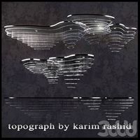
The topograph chandelier by Karim Rashid
... от карима рашида.
the topograph chandelier by karim rashid.http://www.karimrashid.com/projects#category_4/project_247
3d_export
$25
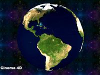
scale relief topographic world map
...ve also added the renderings both with and without texture, so that you will notice that it is done in detail.<br>enjoy it.
3d_export
$50
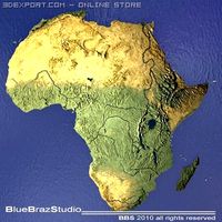
Africa 3D Model
...3dexport africa map terrain elevation satellite landscape mountain land topographic dem africa 3d model braz 21501...
3d_export
$50
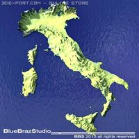
Italy 3D Model
...3dexport italy map terrain elevation satellite landscape mountain land topographic dem italy 3d model braz 21511...
3d_export
$50
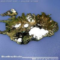
Iceland 3D Model
...3dexport iceland map terrain elevation satellite landscape mountain land topographic dem iceland 3d model braz 21509...
3d_export
$50
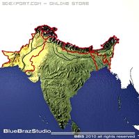
India 3D Model
...3dexport india map terrain elevation satellite landscape mountain land topographic dem india 3d model braz 21510...
3d_export
$50
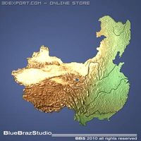
China 3D Model
...3dexport china imap terrain elevation satellite landscape mountain land topographic dem china 3d model braz 21505...
3d_export
$50
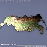
Russia 3D Model
...3dexport russia map terrain elevation satellite landscape mountain land topographic dem russia 3d model braz 21513...
3d_export
$50
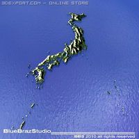
Japan 3D Model
...3dexport japan imap terrain elevation satellite landscape mountain land topographic dem japan 3d model braz 21508...
Grand
3ddd
$1
GRAND (Grand)
...grand (grand)
3ddd
grand , угловой
мягкий уголок мебельной фабрики grand (модель grand)
3ddd
$1

Grand
...
grand , katrin , круглая
кровать фабрики grand
3ddd
$1

Grand / Retto
...grand / retto
3ddd
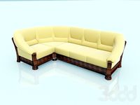
grand , угловой
диван от grand коллекция retto
3ddd
$1
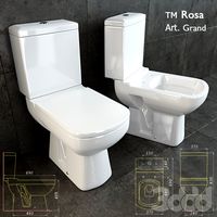
Grand toilet
...nd , rosa , унитаз
унитаз гранд / grand тм rosa
3ddd
$1

Умывальник Grand
...умывальник grand
3ddd
умывальник , grand
умывальник grand 755 х 465 мм со смесителем
3d_export
$80
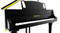
grand piano
...grand piano
3dexport
grand piano detailed
3ddd
$1

KREDO (Grand)
... kredo , угловой
диван в столовую фабрики мягкой мебели grand (модель kredo)
3ddd
$1

Insolito grande
...insolito grande
3ddd
insolito
insolito grande
240х85х73
3ddd
$1
Grand royal
...grand royal
3ddd
grand royal под tv
3ddd
free

Grande Forge
...grande forge
3ddd
grande forge
gf bed
Map
3d_ocean
$5

Map
...map
3docean
geography map ocean travel world world map
a world map
3d_ocean
$5

Old Map
...old map
3docean
dirty map ocean old map paper pirates rotten travel world map
an old map
turbosquid
$3

Map
... available on turbo squid, the world's leading provider of digital 3d models for visualization, films, television, and games.
3d_ocean
$3

Map of Iran
...map of iran
3docean
flag iran map outline
an outline map of iran
3d_ocean
$2

Map of the USA
...map of the usa
3docean
america flag globe map united states usa
an outline map of the usa
3ddd
$1

Abstract Maps
... город , picture
abstract maps by artist jazzberry blue
3d_ocean
$5

Honduras Map
...honduras map
3docean
3d cinema4d honduras map mapa
honduras map designed in cinema 4d r17
3d_ocean
$2

Map of Germany
...map of germany
3docean
black country europe germany gold map outline red yellow
a simple outline map of germany
3d_ocean
$2

Map of Australia
...map of australia
3docean
australia banner country down under earth flag globe map ocean south
an outline map of australia
3d_ocean
$2

Map of Russia
...of russia
3docean
asia banner earth europe flag globe map russia russian federation siberia sovjet union
an outline map of russia