Thingiverse

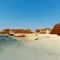
Terrain Model of Binghamton, NY by anoved
by Thingiverse
Last crawled date: 3 years ago
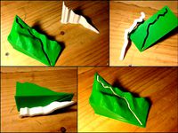
Digital elevation data retrieved from NY Orthos Online, tiled and converted to heightmap images with QGIS, and inefficiently converted to STL using my program hmstl. Terrain is clipped to the Binghamton city limits using a mask image derived from municipal boundaries provided by Broome County GIS.
The red version pictured above was printed in ABS on a library Makerbot 2X. I have since reprinted the model in unpigmented PLA on my Printrbot Simple. Here is a short video clip of adding some detail to the PLA version with acrylic paint: http://www.youtube.com/watch?v=lhWAyQxnE68
The red version pictured above was printed in ABS on a library Makerbot 2X. I have since reprinted the model in unpigmented PLA on my Printrbot Simple. Here is a short video clip of adding some detail to the PLA version with acrylic paint: http://www.youtube.com/watch?v=lhWAyQxnE68
Similar models
3dwarehouse
free

My little house
...my little house
3dwarehouse
#binghamton #house #johnson_city #maire #new_york #ny
3dwarehouse
free

SUNY-Binghamton-Mountainview-HunterDorms
...mton-mountainview-hunterdorms
3dwarehouse
dorm from mountainview community (hunter) from suny-binghamton #binghamton #dorm #suny
grabcad
free

bINGHAMTON MAP
...binghamton map
grabcad
this is my current draft of binghamton university
3dwarehouse
free

Future 86 Over Pass near Maple Street, Binghamton NY
...future 86 over pass near maple street, binghamton ny
3dwarehouse
a simple overpass, hopefully is acceptied.
grabcad
free

Binghamton University
...t, and for one of my projects, i am required to model my university. this is an incomplete model. note - it is not made to scale.
thingiverse
free

Backpack replacement clip by rmil
...e: it might be better to use clip v2 you will get better quality and support can be removed easily later with dremel or just cut.
3dwarehouse
free

Small Terrain
...small terrain
3dwarehouse
my verry first terrain model. using regular version 7. verry easy to accomplish
thingiverse
free

NY Jets Coaster by cementdog
...ny jets coaster by cementdog
thingiverse
ny jets coaster, printed in green pla on my old ender 3
thingiverse
free

Blippi clip on Bowtie by luke9807
... for my kids birthday party.
pla 15% infill
will need to use a knife or razor to separate clip from back of bowtie after print.
thingiverse
free

Barbie Furniture Clip by SodoMojo
...arbie furniture piece. this model is the clip, would be best printed with a flexible material. (i used pla and it worked fine).
Binghamton
thingiverse
free

Binghamton Election District Maps by anoved
...t the upper and lower bounds of the data range accordingly), or use prismap to create extruded prism maps of your own study area.
thingiverse
free

Vestal XX 20k Elevation Route Map by anoved
...the vestal xx, a challenging 20k road race near binghamton ny. http://triplecitiesrunnersclub.org/docs/vxx_recs.html use http://gpxtruder.xyz/ to convert gpx tracks of...
grabcad
free
bINGHAMTON MAP
...binghamton map
grabcad
this is my current draft of binghamton university
grabcad
free

Binghamton updated map
...binghamton updated map
grabcad
this is an updated map of binghamton university
grabcad
free

Binghamton library
...binghamton library
grabcad
s
grabcad
free
Binghamton University
...t, and for one of my projects, i am required to model my university. this is an incomplete model. note - it is not made to scale.
grabcad
free

Binghamton university almost done
...binghamton university almost done
grabcad
a
grabcad
free

Binghamton University Solar Charging Station
...o improve design collaboration and project management. the overall design will create a welcoming space for students and faculty.
grabcad
free

Centering Machine
...the second project in my computer-aided engineering course at binghamton university. i had to design all 31 parts of...
Anoved
thingiverse
free

Marianne by anoved
...t chazal's scan of a marianne bust. closed some holes, clipped background artifacts, and reduced to 50k faces with meshmixer.
thingiverse
free

Faun Torso with Base by anoved
...faun torso with base by anoved
thingiverse
added a lumpy little pedestal for easier printing and display.
thingiverse
free

Customizable Gel Comb by anoved
...f teeth is configurable; tooth width is calculated based on number of teeth, gap between teeth, and available space (comb width).
thingiverse
free

Bike taillight coupler by anoved
...pler to attach a new "laser lane" taillight to planet bike taillight brackets, which are already installed on my bikes.
thingiverse
free
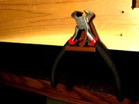
Customizable Plier Holder by anoved
...bench. works alright, but much less stable than the second version, which holds the tools more securely with the heavy side down.
thingiverse
free

Forest Frolic 7k by anoved
...oute. terrain generated from srtm data retrieved from usgs earthexplorer. course generated from gpx recon jog log with gpxtruder.
thingiverse
free
Whiteface Vertical K by anoved
...rtical k route. terrain generated from srtm data retrieved from usgs earthexplorer. course generated from gpx log with gpxtruder.
thingiverse
free

LEGO quadcopter cage by anoved
...ion points. haven't printed it yet. almost certainly requires a lot of revision, as i'm quite new to this sort of design.
thingiverse
free

Forks 15k by anoved
... from mapmyrun trace of course. the file posted here does not include the tcrc logo embossing as pictured in the printed version.
thingiverse
free

Bat-Whistle by anoved
...ally a good idea. since our club is called the bats i remixed this whistle with the club logo to make complimentary bat-whistles!
Ny
3d_export
$5

NY Cap
...ny cap
3dexport
turbosquid
$24

3d NY Candy
... available on turbo squid, the world's leading provider of digital 3d models for visualization, films, television, and games.
turbosquid
$20

NY License plates
... available on turbo squid, the world's leading provider of digital 3d models for visualization, films, television, and games.
turbosquid
$199

NY Style City
...e city for download as blend, max, ma, max, dae, fbx, and obj on turbosquid: 3d models for games, architecture, videos. (1565497)
cg_studio
$160

NY skyline - metlife3d model
...metlife3d model
cgstudio
.3ds - ny skyline - metlife 3d model, royalty free license available, instant download after purchase.
3d_export
$69

NY Taxi Chevrolet Lumina 3D Model
...y taxi chevrolet lumina cab car vehicle automobile sedan ny new york
ny taxi chevrolet lumina 3d model kreations3d 42831 3dexport
turbosquid
$99

The World Trade Center NY
... available on turbo squid, the world's leading provider of digital 3d models for visualization, films, television, and games.
turbosquid
$79

Renaissance Hotel NY - No Ads
... available on turbo squid, the world's leading provider of digital 3d models for visualization, films, television, and games.
3d_export
$69

NY Taxi Ford Crown Victoria 3D Model
... ford crown victoria cab car vehicle automobile sedan ny new york
ny taxi ford crown victoria 3d model kreations3d 43332 3dexport
cg_studio
$120

NY skyline - woolworth building3d model
...model
cgstudio
.3ds - ny skyline - woolworth building 3d model, royalty free license available, instant download after purchase.
Terrain
turbosquid
$49
Terrain
...turbosquid
royalty free 3d model terrain for download as max on turbosquid: 3d models for games, architecture, videos. (1635022)
turbosquid
free

terrain
...turbosquid
royalty free 3d model terrain for download as max on turbosquid: 3d models for games, architecture, videos. (1182323)
turbosquid
$100
Terrain
... available on turbo squid, the world's leading provider of digital 3d models for visualization, films, television, and games.
turbosquid
$35

Terrain
... available on turbo squid, the world's leading provider of digital 3d models for visualization, films, television, and games.
turbosquid
$30

Terrain
... available on turbo squid, the world's leading provider of digital 3d models for visualization, films, television, and games.
turbosquid
$24

Terrain
... available on turbo squid, the world's leading provider of digital 3d models for visualization, films, television, and games.
turbosquid
$15
terrain
... available on turbo squid, the world's leading provider of digital 3d models for visualization, films, television, and games.
turbosquid
$10

Terrain
... available on turbo squid, the world's leading provider of digital 3d models for visualization, films, television, and games.
turbosquid
$5
Terrain
... available on turbo squid, the world's leading provider of digital 3d models for visualization, films, television, and games.
turbosquid
free

Terrain
... available on turbo squid, the world's leading provider of digital 3d models for visualization, films, television, and games.