CG Trader
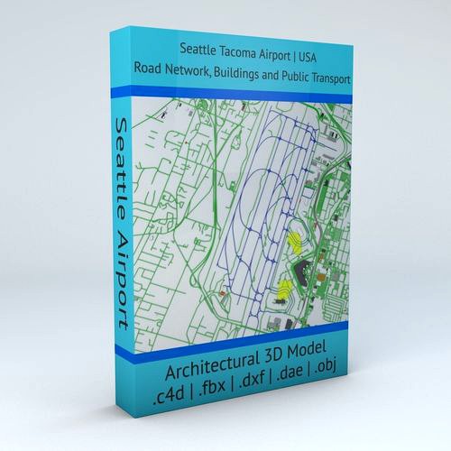
Seattle Tacoma SEA Airport Roads Buildings and Public Transport
by CG Trader
Last crawled date: 1 year, 10 months ago
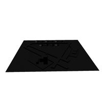
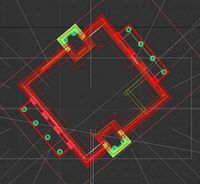
this model is based on real data therefore this is a realistic 3D Model of Seattle Tacoma SEA Airport, USA 4 main object groups included | 1. Buildings 2. Road Network 3. Public Transport 4. Aeroway Buildings has 3 building groups setup so that you can add variety to buildings (color materials and/or textures) Groups can be turned off/on
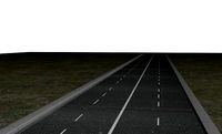
- Road Network has 2 objects included | 1. roads 2. other areas
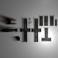
- - Public Transport (2 objects) includes the transport lines and stations
- Aeroway includes the road network for airplanes (runways, airstrips, parking etc.) UV mapped with overlapping UVs
- no textures included / colors setup by materials (can be changed in any 3D software)
- the model is positioned on a flat surface (road network is on the “floor” - no elevation data included)
- geometry is polygonal quads and tris
- model is untextured and renders fast this 3D model is/can be licensed (commercial use is fine) under Creative Commons Attribution-ShareALike 2.0 (CC-BY-SA) license
- buildings and streets data from OpenStreetMap / www.openstreetmap.org Attribution : © OpenStreetMap contributors / http://www.openstreetmap.org/copyright POINTS/VERTS : 108634
POLYGONS : 81354 .c4d - native format
- .fbx - v7.1
- .dae - v1.5
- .dxf
- .obj seattle tacoma usa sea airport architecture infrastructure transportation public transport road network roads buildings international installation air terminals map architectural engineering usa map
- Road Network has 2 objects included | 1. roads 2. other areas
- - Public Transport (2 objects) includes the transport lines and stations
- Aeroway includes the road network for airplanes (runways, airstrips, parking etc.) UV mapped with overlapping UVs
- no textures included / colors setup by materials (can be changed in any 3D software)
- the model is positioned on a flat surface (road network is on the “floor” - no elevation data included)
- geometry is polygonal quads and tris
- model is untextured and renders fast this 3D model is/can be licensed (commercial use is fine) under Creative Commons Attribution-ShareALike 2.0 (CC-BY-SA) license
- buildings and streets data from OpenStreetMap / www.openstreetmap.org Attribution : © OpenStreetMap contributors / http://www.openstreetmap.org/copyright POINTS/VERTS : 108634
POLYGONS : 81354 .c4d - native format
- .fbx - v7.1
- .dae - v1.5
- .dxf
- .obj seattle tacoma usa sea airport architecture infrastructure transportation public transport road network roads buildings international installation air terminals map architectural engineering usa map
Similar models
cg_trader
$29

Chicago OHare ORD Airport Roads Buildings Public Transport
...on public transport road network roads buildings international installation terminals map ohare architectural engineering usa map
cg_trader
$29

San Francisco SFO Airport Roads Buildings and Public Transport
...c transport road network roads buildings international installation terminals map architectural engineering san francisco usa map
cg_trader
$29

Phoenix Sky Harbor PHX Airport Roads Buildings and Public Trans
...ure transportation public road network roads buildings international installation terminals map architectural engineering usa map
cg_trader
$29
Madrid Barajas MAD Airport Roads Buildings and Public Transport
...e transportation public transport road network roads buildings international installation terminals map architectural engineering
cg_trader
$29
Paris Orly ORY Airport Roads Buildings and Public Transport
...e transportation public transport road network roads buildings international installation terminals map architectural engineering
cg_trader
$29
London Heathrow LHR Airport Roads Buildings and Public Transport
...infrastructure transportation public transport road network roads buildings international terminals map architectural engineering
cg_trader
$29

Frankfurt FRA Airport Roads Buildings and Public Transport Lines
...ansportation public transport road network roads buildings international installation air terminals map architectural engineering
cg_trader
$29

Seoul Incheon ICN Airport Roads Buildings and Public Transport
...e transportation public transport road network roads buildings international installation terminals map architectural engineering
cg_trader
$29

Changi SIN Airport Singapore Roads Buildings Public Transport
...ansportation public transport road network roads buildings international installation air terminals map architectural engineering
cg_trader
$29

Tokyo Haneda HND Airport Roads Buildings and Public Transport
...ansportation public transport road network roads buildings international installation air terminals map architectural engineering
Tacoma
turbosquid
$129

Toyota Tacoma
... available on turbo squid, the world's leading provider of digital 3d models for visualization, films, television, and games.
3d_ocean
$89

Toyota Tacoma XRunner 2011
...ed on real car base. model is created accurately, in real units of measurement, qualitatively and maximally close to the origi...
3d_export
$20

2009 Toyota Tacoma 3D Model
...oma low poly lowpoly truck car vehicle pick up large pickup vario minivan cargo
2009 toyota tacoma 3d model be_fast 8206 3dexport
3d_ocean
$89

Toyota Tacoma Double Cab 2011
...al car base. model is created accurately, in real units of measurement, qualitatively and maximally close to the original. mod...
3d_ocean
$89

Toyota Tacoma Access Cab 2011
...ated on real car base. model is created accurately, in real units of measurement, qualitatively and maximally close to the ori...
3d_ocean
$89

Toyota Tacoma Regular Cab 2011
...eated on real car base. model is created accurately, in real units of measurement, qualitatively and maximally close to the or...
3d_export
$99

Toyota Tacoma Access Cab 3D Model
...07 2008 2009 access cab supercab japan pickup utylity vechicle 4x4 offroad
toyota tacoma access cab 3d model squir 11042 3dexport
3d_export
$99

Toyota Tacoma XRunner 2011 3D Model
...x4 crossover pickup pick-up commercial xrunner japan us truck runner
toyota tacoma xrunner 2011 3d model humster3d 38080 3dexport
cg_studio
$119

Toyota Tacoma (2016)3d model
...6 2017 2018
.3ds .obj .max .fbx - toyota tacoma (2016) 3d model, royalty free license available, instant download after purchase.
3d_export
$119

Toyota Tacoma 2016 3D Model
...facelift 2016 2017
toyota tacoma 2016 3d model download .c4d .max .obj .fbx .ma .lwo .3ds .3dm .stl swan3dstudios 109666 3dexport
Seattle
3ddd
$1

Диван Seattle
... seattle , угловой
диван seattle от фабрики 8 марта
turbosquid
$50

Seattle Cityscape
...
royalty free 3d model seattle cityscape for download as max on turbosquid: 3d models for games, architecture, videos. (1482008)
turbosquid
$1199

CityKit Seattle
... available on turbo squid, the world's leading provider of digital 3d models for visualization, films, television, and games.
turbosquid
$4

Seattle tex
... available on turbo squid, the world's leading provider of digital 3d models for visualization, films, television, and games.
turbosquid
$199

Seattle City
...le city road street network for download as obj, c4d, and fbx on turbosquid: 3d models for games, architecture, videos. (1428519)
turbosquid
$7

SEATTLE chair, Poliform
...lty free 3d model seattle chair, poliform for download as max on turbosquid: 3d models for games, architecture, videos. (1314014)
turbosquid
$299

Seattle + Terrain 3D
... model seattle + terrain 3d for download as max, obj, and fbx on turbosquid: 3d models for games, architecture, videos. (1444146)
turbosquid
$9

Poliform Seattle Chair
...odel poliform seattle chair for download as max, obj, and fbx on turbosquid: 3d models for games, architecture, videos. (1399712)
turbosquid
$5

Seattle Ferry Terminal Base
... available on turbo squid, the world's leading provider of digital 3d models for visualization, films, television, and games.
turbosquid
$3

Glass Table 016 - Seattle
... available on turbo squid, the world's leading provider of digital 3d models for visualization, films, television, and games.
Airport
3ddd
$1

Poliform Airport
...poliform airport
3ddd
poliform , airport
диван poliform airport
turbosquid
$29

airport
...turbosquid
royalty free 3d model airport for download as c4d on turbosquid: 3d models for games, architecture, videos. (1659395)
turbosquid
$10

Airport
...rbosquid
royalty free 3d model airport for download as blend on turbosquid: 3d models for games, architecture, videos. (1338079)
turbosquid
$35

AIRPORT
... free 3d model airport for download as 3ds, max, obj, and fbx on turbosquid: 3d models for games, architecture, videos. (1419439)
turbosquid
$1
Airport
... available on turbo squid, the world's leading provider of digital 3d models for visualization, films, television, and games.
turbosquid
free

Airport
... available on turbo squid, the world's leading provider of digital 3d models for visualization, films, television, and games.
3d_export
$65

airport
...airport
3dexport
simple rendering of the scene file
3d_export
$65

airport
...airport
3dexport
simple rendering of the scene file
3d_export
$65

airport
...airport
3dexport
simple rendering of the scene file
3d_export
$65

airport
...airport
3dexport
simple rendering of the scene file
Public
3d_ocean
$25
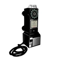
Public telephone
...public telephone
3docean
public telephone
3d model and render (cycles) public telephone 1957
3d_ocean
$2
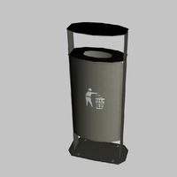
Public Trash
...public trash
3docean
builds city concept trash
public trash
3d_ocean
$5
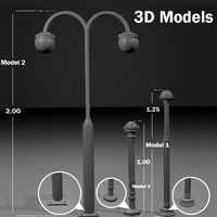
Public Lights
...s
3docean
decor lights outside public ready
this file includes 3 public lights models that you can use in your sceen and prejecs.
3d_export
$10

Public snake
...
the public seats are designed in a snake-like shape, divided into two sides, with a small tree as a divider to divide the zone.
turbosquid
$10

Public Fountain
...squid
royalty free 3d model public fountain for download as on turbosquid: 3d models for games, architecture, videos. (1693150)
turbosquid
$29

Public Library
...uid
royalty free 3d model public library for download as skp on turbosquid: 3d models for games, architecture, videos. (1250245)
turbosquid
$10
Public wc
...rbosquid
royalty free 3d model public wc for download as max on turbosquid: 3d models for games, architecture, videos. (1427486)
turbosquid
$6

public building
...lty free 3d model public building for download as max and c4d on turbosquid: 3d models for games, architecture, videos. (1451902)
3d_export
free

Public bath
...public bath
3dexport
https://www.dock4all.com/
turbosquid
$19

Public Phone
...ree 3d model public phone for download as blend, obj, and fbx on turbosquid: 3d models for games, architecture, videos. (1707091)
Sea
3ddd
$1

Sea Silver
...sea silver
3ddd
плитка , sea silver
плитка sea silver
3d_ocean
$13

Sea turtle
...sea turtle
3docean
lowpoly sea turtle
3d model of sea turtle.
turbosquid
$17

Sea
...
royalty free 3d model sea for download as max, obj, and stl on turbosquid: 3d models for games, architecture, videos. (1448257)
turbosquid
$16

Sea
...
royalty free 3d model sea for download as max, obj, and stl on turbosquid: 3d models for games, architecture, videos. (1381127)
turbosquid
$15

Sea
...
royalty free 3d model sea for download as max, obj, and stl on turbosquid: 3d models for games, architecture, videos. (1347433)
turbosquid
$13

Sea
...
royalty free 3d model sea for download as max, obj, and stl on turbosquid: 3d models for games, architecture, videos. (1383491)
turbosquid
$9

Sea
...
royalty free 3d model sea for download as max, obj, and stl on turbosquid: 3d models for games, architecture, videos. (1383007)
3d_export
$10

sea container
...sea container
3dexport
sea, cargo container
turbosquid
$12

Sea Stars Pentagrams sea creatures
...model sea stars pentagrams sea creatures for download as max on turbosquid: 3d models for games, architecture, videos. (1629668)
turbosquid
$9

Sea
... available on turbo squid, the world's leading provider of digital 3d models for visualization, films, television, and games.
Transport
turbosquid
$2

Transportation
...quid
royalty free 3d model transportation for download as ma on turbosquid: 3d models for games, architecture, videos. (1393977)
turbosquid
$20
Transport
... available on turbo squid, the world's leading provider of digital 3d models for visualization, films, television, and games.
turbosquid
$3

transporter
... available on turbo squid, the world's leading provider of digital 3d models for visualization, films, television, and games.
turbosquid
free

transporter
... available on turbo squid, the world's leading provider of digital 3d models for visualization, films, television, and games.
turbosquid
free

Transporter
... available on turbo squid, the world's leading provider of digital 3d models for visualization, films, television, and games.
turbosquid
free
transport
... available on turbo squid, the world's leading provider of digital 3d models for visualization, films, television, and games.
3d_ocean
$12

bags transport
...bags transport
3docean
bags bags transport travel vacation
bags and trasport car
3d_export
$8

CubeMechine transport
...xport
cubemechine a transport machine with a cube shape and 4 joints, it comes with 4 textures included, ik in the blender scene
archive3d
free
Transport 3D Model
...ars
transport muti-troops n090316 - 3d model (*.gsm+*.3ds+*.max) for interior 3d visualization.
3d_export
$9

volkswagen transporter t2
...volkswagen transporter t2
3dexport
volkswagen transporter t2
Roads
3d_export
free
road
...road
3dexport
ready road with textures.
turbosquid
$4

Cross road Road-sign
...ss road road-sign for download as 3ds, dae, fbx, obj, and stl on turbosquid: 3d models for games, architecture, videos. (1516042)
3d_ocean
$39
Road
...torway nascar oval poly race racetrack raceway racing realtime road speedway talladega track way
racing games for the road system
turbosquid
$1
road
...ad
turbosquid
royalty free 3d model road for download as max on turbosquid: 3d models for games, architecture, videos. (1167278)
3d_ocean
$9
Road Signs
...road signs
3docean
outdoor road signs signpost waymark
road signs 3d models.
3d_export
$5
road cone
...road cone
3dexport
road cone
3d_export
free
road
...road
3dexport
3d_export
$5

road markings
...road markings
3dexport
construction of road markings
turbosquid
$25
Road
...lty free 3d model road for download as png, 3ds, obj, and fbx on turbosquid: 3d models for games, architecture, videos. (1380086)
3d_export
$5

road sign
...road sign
3dexport
road sign with the texture of a cyclist.
Buildings
archibase_planet
free
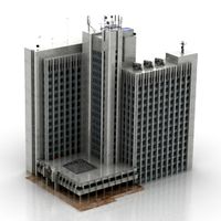
Building
...building high-rise building office building construction
building n050115 - 3d model (*.gsm+*.3ds) for exterior 3d visualization.
3d_export
$5
building
...building
3dexport
clasic building
3ddd
$1
building
...building
3ddd
здание
building
archibase_planet
free
Building
...lanet
building office office building construction
building n090914 - 3d model (*.gsm+*.3ds+*.max) for exterior 3d visualization.
archibase_planet
free
Building
...net
building tower construction high-rise building
building n100214 - 3d model (*.gsm+*.3ds+*.max) for exterior 3d visualization.
3d_export
free
Building
...building
3dexport
low poly building;
3d_export
free
Building
...building
3dexport
low poly building;
3d_export
free
Building
...building
3dexport
low poly building;
3d_export
free
Building
...building
3dexport
low poly building;
3d_export
free
Building
...building
3dexport
low poly building;