CG Trader
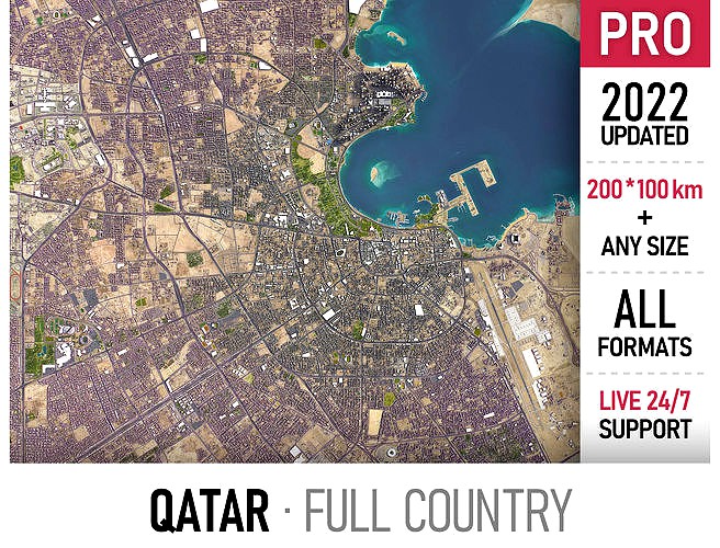
Qatar
by CG Trader
Last crawled date: 1 year, 10 months ago
Coordinate reference system: QND95 / Qatar National Grid (EPSG:2932) Scene size: 200 x 100 km Data used: May 2022 MESSAGE US BEFORE THE PURCHASE Get FREE sample model Customization requests Any scene size (custom area crop) Any coordinate reference system Various levels of detail (LODs) Update to the latest data Flexible pricing (select only the options you need) PACKAGE CONTENTS This product includes scenes of various sizes and formats File formats (software supported) MAX - Autodesk 3dsMax FBX, OBJ, DAE - Exchange Formats GLTF, GLB - Games, Web, AR/VR (request) UNITYPACKAGE - Unity 3D 3DM - Rhino 3D SKP - SketchUp RVT - Autodesk Revit (request) STL - 3D Print (request) C4D - Cinema4D BLEND - Blender MA, MB - Autodesk Maya DWG, DXF - Autodesk AutoCAD BASIC OPTIONS (included with the purchase) KEY BENEFITS 24/7 customer support 100+ detailed landmarks with the regular updates and improvements High-resolution surface texture (1 meter resolution satellite image) 100% buildings coverage from buildings footprint polygon geometries in all 50 U.S. States Buildings, landuse areas, roads and railways split by type (layers / named objects) The surface is flat, easy to add details and edit geometry (terrain on request) Realistic low-poly trees and forests (max, fbx included, other formats on request) Product is ready to render out-of-the-box (3ds Max + Corona Renderer) PRESENTATION IMAGES 4K high-resolution realistic renderings (refer to images for level of detail or request close-ups) Rendered in 3dsMax (other software requires its own rendering settings) MATERIALS Trees, vegetation, landuse and airport surface with the textures assigned Buildings are UVW mapped, split by material IDs, no textures assigned CUSTOM OPTIONS (available at a special price - please request before buying) TOPOGRAPHY TERRAIN Up to 1 meter accuracy raw terrain object (USGS 3D Elevation Program) Multiple LODs optimized for the best polycount/details balance Contour lines (up to 1 meter interval) High-resolution (up to 20cm accuracy) satellite or surface texture Buildings and roads placed on the optimized terrain OTHER EXTRAS On-demand custom update Crop to custom area size or slice to tiles Procedural textures assigned to all buildings Individual buildings and streets (with address and/or name) Administrative boundaries of all levels (named polygons or outlines) Road and railway splines for traffic animation Public transport stops with names city map model area building center skyline landscape topography suburb downtown skyscraper airport urban street sketchup rhino qatar doha arab exterior cityscape city building city landscape city map city skyline city street rhino building
Similar models
cg_trader
$399

Shanghai
...aphy neighborhood exterior cityscape city building city landscape city map city skyline city street exterior house house exterior
cg_trader
$399

Manchester
...xtents urban street park sketchup manchester uk exterior cityscape city building city landscape city map city skyline city street
cg_trader
$399

Toronto
...port skyline suburb town downtown toronto map area scene sketchup center topography landscape park city street exterior cityscape
cg_trader
$299

Doha Hamad Airport
...ing concourse gateway facility gate hub modern runway city passenger hangar skywalk plane doha hamad doh qatar exterior cityscape
cg_trader
$399

Perth
...ography suburb neighborhood downtown skyscraper airport urban street park sketchup perth australia city street exterior cityscape
cg_trader
$399

Lusail
...2 city map model area building center skyline landscape topography skyscraper airport urban street park lusail exterior cityscape
cg_trader
$399

Guangzhou
...ino unity airport park exterior cityscape china map city building city landscape city map city skyline city street rhino building
cg_trader
$399

Berkeley
...ding center skyline landscape topography suburb neighborhood downtown airport urban street park sketchup rhino exterior cityscape
cg_trader
$399

Dubai
...ubai uae skyscraper downtown map city area center scene skyline sketchup landscape topography urban park rhino exterior cityscape
cg_trader
$399

Fremantle
...rea building center skyline landscape topography suburb downtown airport urban street park sketchup rhino port exterior cityscape
Qatar
3ddd
$1

Porcelanosa | Qatar
...d
porcelanosa , qatar , плитка
3д модель плитки
3d_export
$20

Qatar Army Tank
...qatar army tank
3dexport
qatar army tank with qatar army plate in front side
3d_export
$5

Man qatar 2022
...man qatar 2022
3dexport
man qatar 2022
turbosquid
$1

Flag of Qatar
...del flag of qatar for download as max, 3ds, dxf, fbx, and obj on turbosquid: 3d models for games, architecture, videos. (1594879)
turbosquid
$100

Bahrain & Qatar
... available on turbo squid, the world's leading provider of digital 3d models for visualization, films, television, and games.
3d_export
$99

aspire masjid in doha qatar
...aspire masjid in doha qatar
3dexport
aspire masjid in doha qatar
3d_export
$99

aspire tower in doha qatar
...aspire tower in doha qatar
3dexport
aspire tower in doha qatar
turbosquid
$50

QATAR AIRWAYS FLIGHT
...oyalty free 3d model qatar airways flight for download as fbx on turbosquid: 3d models for games, architecture, videos. (1460431)
turbosquid
$199

A350-800 Qatar
... available on turbo squid, the world's leading provider of digital 3d models for visualization, films, television, and games.
turbosquid
$199

A350-1000 Qatar
... available on turbo squid, the world's leading provider of digital 3d models for visualization, films, television, and games.