CG Trader
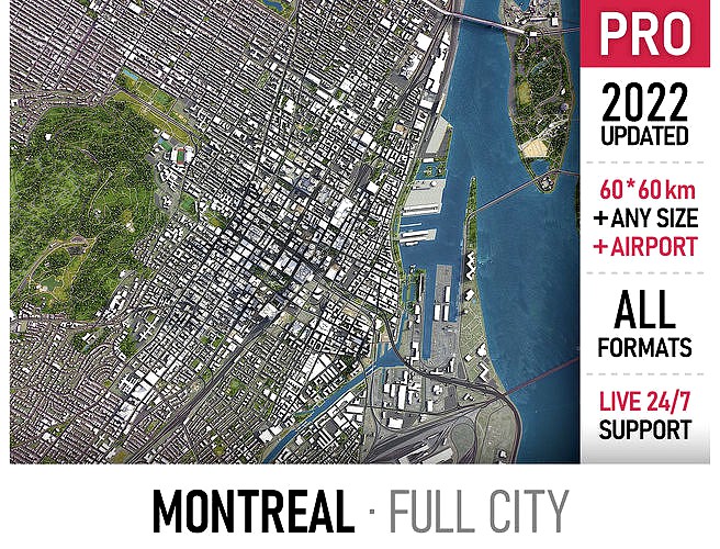
Montreal
by CG Trader
Last crawled date: 1 year, 10 months ago
Coordinate reference system: NAD83 / MTM zone 8 (EPSG:32188) Scene size: up to 60 x 60 km Data used: May 2022 MESSAGE US BEFORE THE PURCHASE Get FREE sample model Customization requests Any scene size (custom area crop) Any coordinate reference system Various levels of detail (LODs) Update to the latest data Flexible pricing (select only the options you need) PACKAGE CONTENTS This product includes scenes of various sizes and formats File formats (software supported) MAX - Autodesk 3dsMax FBX, OBJ, DAE - Exchange Formats GLTF, GLB - Games, Web, AR/VR (request) UNITYPACKAGE - Unity 3D 3DM - Rhino 3D SKP - SketchUp RVT - Autodesk Revit (request) STL - 3D Print (request) C4D - Cinema4D BLEND - Blender MA, MB - Autodesk Maya DWG, DXF - Autodesk AutoCAD BASIC OPTIONS (included with the purchase) KEY BENEFITS 24/7 customer support 30+ detailed landmarks with the regular updates and improvements High-resolution surface texture (1 meter resolution satellite image) 100% buildings coverage from buildings footprint polygon geometries in Canada Buildings, landuse areas, roads and railways split by type (layers / named objects) The surface is flat, easy to add details and edit geometry (terrain on request) Realistic low-poly trees and forests (max, fbx included, other formats on request) Product is ready to render out-of-the-box (3ds Max + Corona Renderer) PRESENTATION IMAGES 4K high-resolution realistic renderings (refer to images for level of detail or request close-ups) Rendered in 3dsMax (other software requires its own rendering settings) MATERIALS Trees, vegetation, landuse and airport surface with the textures assigned Buildings are UVW mapped, split by material IDs, no textures assigned CUSTOM OPTIONS (available at a special price - please request before buying) TOPOGRAPHY TERRAIN Up to 1 meter accuracy raw terrain object (USGS 3D Elevation Program) Multiple LODs optimized for the best polycount/details balance Contour lines (up to 1 meter interval) High-resolution (up to 20cm accuracy) satellite or surface texture Buildings and roads placed on the optimized terrain OTHER EXTRAS On-demand custom update Crop to custom area size or slice to tiles Procedural textures assigned to all buildings Individual buildings and streets (with address and/or name) Administrative boundaries of all levels (named polygons or outlines) Road and railway splines for traffic animation Public transport stops with names model city building skyscraper urban airport skyline residential area downtown montreal suburb landmark map center landscape topography neighborhood park sketchup exterior cityscape
Similar models
cg_trader
$399

Toronto
...port skyline suburb town downtown toronto map area scene sketchup center topography landscape park city street exterior cityscape
cg_trader
$399

Kuwait
...downtown center building map area skyscraper park scene country roads street model skyline topography sketchup exterior cityscape
cg_trader
$199

Montreal - Pierre Elliott Trudeau Airport
... concourse gateway facility passenger hangar gate skywalk plane hub modern montreal pierre elliott trudeau yul exterior cityscape
cg_trader
$399

Berkeley
...ding center skyline landscape topography suburb neighborhood downtown airport urban street park sketchup rhino exterior cityscape
cg_trader
$399

Berlin
...dential area berlin germany center skyscraper landscape scene square environment sketchup map model topography exterior cityscape
cg_trader
$399

Dubai
...ubai uae skyscraper downtown map city area center scene skyline sketchup landscape topography urban park rhino exterior cityscape
cg_trader
$399

Fremantle
...rea building center skyline landscape topography suburb downtown airport urban street park sketchup rhino port exterior cityscape
cg_trader
$399

Perth
...ography suburb neighborhood downtown skyscraper airport urban street park sketchup perth australia city street exterior cityscape
cg_trader
$399

Baghdad
...kyline landscape topography suburb neighborhood downtown airport urban street park sketchup rhino baghdad iraq exterior cityscape
cg_trader
$399

Hong Kong
...kyline residential area hong kong shenzhen china downtown map center landscape topography suburb park sketchup exterior cityscape
Montreal
3ddd
$1

Woffi Montreal
...woffi montreal
3ddd
woffi montreal
3ddd
free

Montreal armchair
... кресло-мешок
кресло montreal armchair baxterhttp://www.baxter.it/en/maisonobjet-2012-paris
3ddd
$1

BUT- MONTREAL
...but- montreal
3ddd
кинотеатр
кресло для кинотеатра
3ddd
$1

Диван Montreal
...mp;amp; zeit , угловой
производитель möbel&zeit;
коллекция interior
модель montreal
turbosquid
$49

Recor Montreal
...d model recor montreal for download as 3ds, max, obj, and fbx on turbosquid: 3d models for games, architecture, videos. (1275325)
turbosquid
$4

Cup Montreal
... available on turbo squid, the world's leading provider of digital 3d models for visualization, films, television, and games.
3ddd
$1

Биокамин Decoflame Montreal
...ecoflame montreal с автоматической горелкой denver e-ribbon fire
ribbon 2200x400x300mm ft2000mm glass
в архиве vray+corona model
3ddd
$1

MONTREAL ARMCHAIR BAXTER
...ddd
кресло-мешок , baxter
montreal armchair baxter
105x120 h70
max 2014+ max 2011+ fbx
3d_ocean
$7

Lowpoly Montreal Building
...l of an iconic building in montreal canada. this model was created in cinema 4d r16 if you intend to use the .c4d file thank you!
turbosquid
$40

Sofa Montreal leather
... sofa montreal leather for download as 3ds, max, obj, and fbx on turbosquid: 3d models for games, architecture, videos. (1208813)