Artstation
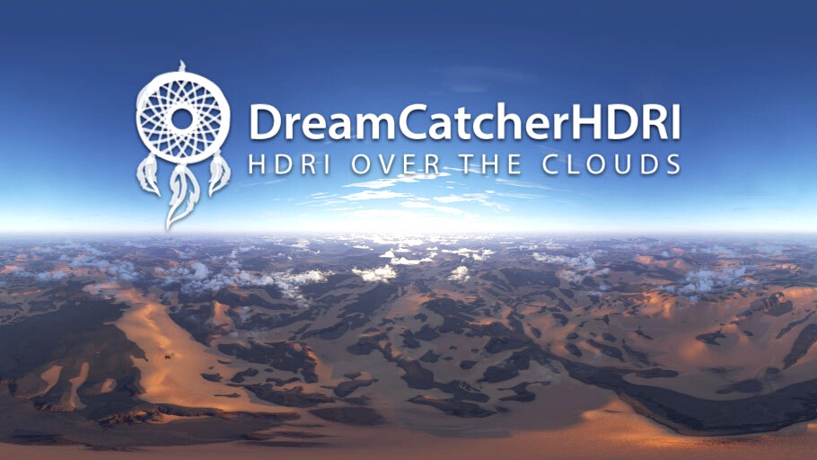
Map #147 Sunset Desert @ 9,000 feet
by Artstation
Last crawled date: 1 year, 6 months ago
HDRI maps designed to simplify the creation of 3D aerial environments and quickly produce still or animated photorealistic images.
Product Contains:
1 HDRI map RGB 32 bit
1 ZDepth Clouds 32 bit
1 ZDepth Ground 32 bit
Image details:
Purpose: 360° HDRI equirectangular image for Image Based Lighting
Date: 04/22
Name: Ref147_Sunset_Desert
Format: 32bit .exr
Camera Altitude: 3,000 m / 9,000 feet
Time of day: Sunset
Cloud Layer1: Cirrus
Cloud Layer2: Small Cumulus
Sun brightness: 14.26 EV
ZDepth maps: Yes (Clouds + Ground)
Modeled after nature:
The primary objective of DreamCatcherHDRI images is to faithfully reproduce earthly weather conditions
Our maps scrupulously respect exposure values produced by the sun depending on the time of day. In a single image, the amplitude of exposure can range from -6 EV to +16 EV, which corresponds to earthly lighting conditions.
The types of clouds (cumulus, cirrus, stratocumulus, etc…) are recreated with their respective sizes, shapes and altitudes. Different types of atmospheres are produced with their wavelengths corresponding to the air’s density and the sun’s position. The light’s behavior in the atmosphere (translucency, accumulation, dispersion) is adjusted with care, allowing to obtain light, cottony clouds that are pearly and translucent. This photorealistic result is further enriched by esthetic choices so that our environments remain pleasing to the eye.
This rigor and demanding level of excellence are necessary in order to gurantee quality scenes for our clients.
About DreamCatcherHDRI:
We have 25 years of experience in the CGI field including a decade in the aeronautical and aerospatial industry (Dassault Aviation, Swiss Space Systems, Airbus Helicopters)
Similar models
artstation
$19

Map #148 Morning Desert @ 9,000 feet
...ield including a decade in the aeronautical and aerospatial industry (dassault aviation, swiss space systems, airbus helicopters)
artstation
$19

Map #145 Sunrise Desert @ 9,000 feet
...ield including a decade in the aeronautical and aerospatial industry (dassault aviation, swiss space systems, airbus helicopters)
artstation
$19

Map #150 Midday Desert @ 9,000 feet
...ield including a decade in the aeronautical and aerospatial industry (dassault aviation, swiss space systems, airbus helicopters)
artstation
$19

Map #149 Afternoon Desert @ 9,000 feet
...ield including a decade in the aeronautical and aerospatial industry (dassault aviation, swiss space systems, airbus helicopters)
artstation
$19

Map #143 Sunset Desert @ 3,000 feet
...ield including a decade in the aeronautical and aerospatial industry (dassault aviation, swiss space systems, airbus helicopters)
artstation
$19

Map #140 Morning Desert @ 3,000 feet
...ield including a decade in the aeronautical and aerospatial industry (dassault aviation, swiss space systems, airbus helicopters)
artstation
$19

Map #137 Sunrise Desert @ 3,000 feet
...ield including a decade in the aeronautical and aerospatial industry (dassault aviation, swiss space systems, airbus helicopters)
artstation
$19

Map #139 Sunrise Desert @ 3,000 feet
...ield including a decade in the aeronautical and aerospatial industry (dassault aviation, swiss space systems, airbus helicopters)
artstation
$19

Map #138 Sunrise Desert @ 3,000 feet
...ield including a decade in the aeronautical and aerospatial industry (dassault aviation, swiss space systems, airbus helicopters)
artstation
$19

Map #144 Morning Desert @ 3,000 feet
...ield including a decade in the aeronautical and aerospatial industry (dassault aviation, swiss space systems, airbus helicopters)
147
3ddd
$1

alfa 147 sport
...alfa 147 sport
3ddd
alfa romeo 147 ligt tuning
turbosquid
$499

ALFA 147
... available on turbo squid, the world's leading provider of digital 3d models for visualization, films, television, and games.
turbosquid
$9

Office 147
... available on turbo squid, the world's leading provider of digital 3d models for visualization, films, television, and games.
evermotion
$7

railing 147 am79
...key sculptures am79 railing 147
highly detailed architecture railing with all textures and materials.. evermotion 3d models shop.
evermotion
$120

Archmodels vol. 147
...collection comes with high quality decorative walls and furniture with all the textures and materials. evermotion 3d models shop.
evermotion
$15

hedge 147 am126
...l of hedge with all textures, shaders and materials. it is ready to use, just put it into your scene.. evermotion 3d models shop.
turbosquid
$119

147 Condos Estate
...y free 3d model 147 condos estate for download as max and max on turbosquid: 3d models for games, architecture, videos. (1556565)
turbosquid
$7

Rug Set 147
...y free 3d model rug set 147 for download as max, obj, and fbx on turbosquid: 3d models for games, architecture, videos. (1436287)
3d_export
$18

ancient china-interior 147
...ancient china-interior 147
3dexport
ancient china-interior 147<br>3ds max 2015
turbosquid
$60

Alfa Romeo 147
... available on turbo squid, the world's leading provider of digital 3d models for visualization, films, television, and games.
Sunset
3d_export
$5

retro sunset
...retro sunset
3dexport
very nice retro sunset selfmade.
turbosquid
$50

Sunset on the mountain
...alty free 3d model sunset on the mountain for download as max on turbosquid: 3d models for games, architecture, videos. (1293089)
turbosquid
$8

Ocean Sunset
...uid
royalty free 3d model ocean sunset for download as blend on turbosquid: 3d models for games, architecture, videos. (1493645)
3d_ocean
$9

Cloudy Sunset
...tical cross version. spherical map has a resolution: 5000×2500 px. light probe resolution: 3000×3000 px vertical cross resolut...
3d_export
$5

Sunset 3D Model
...sunset 3d model
3dexport
sunset 3d model soumyap 39597 3dexport
3ddd
$1

Los Angeles Sunset
...los angeles sunset
3ddd
панорама
7500x3750 spherical panoramic hdr of a sunset.
3d_ocean
$9

Alien Sunset
...cal cross version. spherical map has a resolution: 5000×2500 px. light probe resolution: 3000×3000 px vertical cross resolutio...
3ddd
$1

Cappellini (SUNSET)
...cappellini (sunset)
3ddd
cappellini
www.cappellini.it
3d_ocean
$9

Lime Sunset
...cal cross version. spherical map has a resolution: 5000×2500 px. light probe resolution: 3000×3000 px vertical cross resolutio...
turbosquid
$20

sunset sit.max
... available on turbo squid, the world's leading provider of digital 3d models for visualization, films, television, and games.
000
turbosquid
$15

Sofa 000
...free 3d model sofa 000 for download as 3ds, max, obj, and fbx on turbosquid: 3d models for games, architecture, videos. (1401892)
turbosquid
$40

TIRE 000
... available on turbo squid, the world's leading provider of digital 3d models for visualization, films, television, and games.
turbosquid
$10

chair 000
... available on turbo squid, the world's leading provider of digital 3d models for visualization, films, television, and games.
turbosquid
$32
MOD A 000.max
... available on turbo squid, the world's leading provider of digital 3d models for visualization, films, television, and games.
turbosquid
$1

electric engine BLDC with water cooling for printing 10 000 W stl
...with water cooling for printing 10 000 w stl for download as on turbosquid: 3d models for games, architecture, videos. (1632791)
3ddd
$1

Ручки для кухни Giusti WMN.721Y.128.XXX и WPO.721X.000.XXX
...установить свою степень сглаживания, изначально установлено 2.
в архиве библиотека материалов для ручек. всё настроено для vray.
3d_export
$5
baby
...3dexport baby head<br>poligon min 106 468 x 7 473 000 , max 6 859 000 x 7 473...
3ddd
$1

Статуетка
...статуетка 3ddd 000 00000 0000 00000 0 0 000 0 0 0...
3d_export
$6

Rome Centurion Sculpt
...sculpt 3dexport rome centurion high poly model .ztl 75 000 000...
3d_export
$5

Wendigo Ram Sculpt
...sculpt 3dexport wendigo ram high poly model .ztl 36 000 000...
Desert
3d_export
$5

Desert
...desert
3dexport
oasis in the desert
3d_export
$5
desert with crystals
...desert with crystals
3dexport
desert with crystals
3d_export
$8

Desert Eagle
...desert eagle
3dexport
desert eagle pistol
3ddd
free

Desert Angel
...desert angel
3ddd
ангел
desert angel
turbosquid
free

desert
...
free 3d model desert for download as 3ds, obj, c4d, and fbx on turbosquid: 3d models for games, architecture, videos. (1479998)
3d_export
$5

desert of crystals
...desert of crystals
3dexport
cool model (desert of crystals)
3d_export
$25

desert eagle
...desert eagle
3dexport
desert eagle for gaming or 3d video
3d_export
$5

deserted road
...deserted road
3dexport
desert road made in pixel style
turbosquid
$125

Desert
...3d model desert for download as blend, dae, fbx, obj, and stl on turbosquid: 3d models for games, architecture, videos. (1556611)
turbosquid
$99

desert
... available on turbo squid, the world's leading provider of digital 3d models for visualization, films, television, and games.
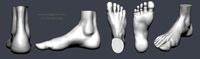
Feet
3d_export
$30
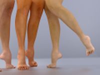
Legs and feet High feet 3D Model
...t high feet 3d model
3dexport
feet shoes sandal barefoot leg women
legs and feet high feet 3d model adrianaamerina 96817 3dexport
3ddd
$1
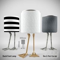
DUCK FEET LAMP
...duck feet lamp
3ddd
утка
duck feet lamp
turbosquid
$19
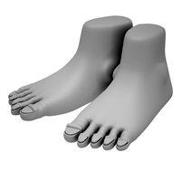
Feets 01
...3d model feets 01 for download as max, max, max, fbx, and obj on turbosquid: 3d models for games, architecture, videos. (1624047)
turbosquid
$2
Robo3D Feet
... available on turbo squid, the world's leading provider of digital 3d models for visualization, films, television, and games.
turbosquid
free

Hands and Feet
... available on turbo squid, the world's leading provider of digital 3d models for visualization, films, television, and games.
turbosquid
free
Feet study
... available on turbo squid, the world's leading provider of digital 3d models for visualization, films, television, and games.
turbosquid
$9

Female Feet 01
...oyalty free 3d model feet 01 for download as ma, obj, and fbx on turbosquid: 3d models for games, architecture, videos. (1446069)
turbosquid
$15
Viabizzuno Big Feet
... available on turbo squid, the world's leading provider of digital 3d models for visualization, films, television, and games.
turbosquid
$10

Male Legs and Feet
... available on turbo squid, the world's leading provider of digital 3d models for visualization, films, television, and games.
turbosquid
free

container 20 feet
... available on turbo squid, the world's leading provider of digital 3d models for visualization, films, television, and games.
9
3ddd
$1
9
...9
3ddd
консоль
9
turbosquid
$40

Apple iPhone 9 & 9+
...del apple iphone 9 & 9+ for download as max, obj, and fbx on turbosquid: 3d models for games, architecture, videos. (1284550)
turbosquid
$12

Calligraphic Digit 9 Number 9
...hic digit 9 number 9 for download as max, obj, fbx, and blend on turbosquid: 3d models for games, architecture, videos. (1389349)
3ddd
$1

PLANTS 9
...plants 9
3ddd
папоротник , кашпо
plant 9.. hope u all like it
design_connected
$11
194 9
...194 9
designconnected
194 9 computer generated 3d model. designed by lissoni, piero.
design_connected
free
Tangram 9
...tangram 9
designconnected
free 3d model of tangram 9 by lago designed by lago, daniele.
design_connected
$11
Domino 9
...domino 9
designconnected
zanotta domino 9 computer generated 3d model. designed by progetti, emaf.
design_connected
$20
Docks 9
...docks 9
designconnected
gandia blasco docks 9 computer generated 3d model. designed by romero vallejo.
3d_export
$80

mq-9
...mq-9
3dexport
3d_export
$6
washbasin-9
...washbasin-9
3dexport
Map
3d_ocean
$5

Map
...map
3docean
geography map ocean travel world world map
a world map
3d_ocean
$5

Old Map
...old map
3docean
dirty map ocean old map paper pirates rotten travel world map
an old map
turbosquid
$3

Map
... available on turbo squid, the world's leading provider of digital 3d models for visualization, films, television, and games.
3d_ocean
$3

Map of Iran
...map of iran
3docean
flag iran map outline
an outline map of iran
3d_ocean
$2

Map of the USA
...map of the usa
3docean
america flag globe map united states usa
an outline map of the usa
3ddd
$1

Abstract Maps
... город , picture
abstract maps by artist jazzberry blue
3d_ocean
$5

Honduras Map
...honduras map
3docean
3d cinema4d honduras map mapa
honduras map designed in cinema 4d r17
3d_ocean
$2

Map of Germany
...map of germany
3docean
black country europe germany gold map outline red yellow
a simple outline map of germany
3d_ocean
$2

Map of Australia
...map of australia
3docean
australia banner country down under earth flag globe map ocean south
an outline map of australia
3d_ocean
$2

Map of Russia
...of russia
3docean
asia banner earth europe flag globe map russia russian federation siberia sovjet union
an outline map of russia