CG Trader
Madison Dane County Airport
by CG Trader
Last crawled date: 1 year, 10 months ago
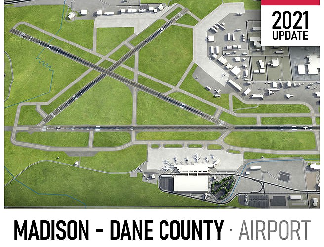
This is exact and accurate to-scale 3D model of Madison Dane County Airport (MSN) and its surrounding area based on GIS data (February 2021) Dimensions: 10x10km File units: Meters Scale: 1:1 FORMATS INCLUDED - MAX - Autodesk 3dsMax
- FBX, OBJ, DAE - Exchange Formats
- GLTF, GLB - Games, Web, AR/VR (request)
- UNITYPACKAGE - Unity 3D
- 3DM - Rhino 3D
- SKP - SketchUp
- RVT - Autodesk Revit (request)
- STL - 3D Print (request)
- C4D - Cinema4D
- BLEND - Blender
- MA, MB - Autodesk Maya
- DWG, DXF - Autodesk AutoCAD PRODUCT INFO KEY BENEFITS Live 24/7 support Buildings, landuse areas, roads and railways split by type (see scene structure) The surface is flat, easy to add details and edit geometry Realistic low-poly trees, forests and airplanes Product is ready to render out-of-the-box (3dsmax + corona renderer) EXTRAS (please request before the purchase) Crop to custom area or slice to tiles Topography terrain based on SRTM or LIDAR elevation data (3-5 LODs, optimized) Named individual buildings and streets (with address and/or name) Any coordinate system (Spherical Transverse Mercator projection by defaut) Road and railway splines for traffic animation PRESENTATION IMAGES 4K high-resolution realistic renderings (refer to images for level of detail) 3dsMax was used, so the other softwares requires its own rendering settings MATERIALS Buildings are UVW mapped, split by material IDs, no textures assigned Trees, vegetation, landuse and airport surface with the textures assigned SCENE STRUCTURE - model is organized by layers, all objects split by type and named properly AIRPORT building (terminal, gates) apron taxiway runway marking ROADS highways primary secondary residential service railway LANDUSE residential industrial construction VEGETATION forest grass scrub SUPPORT - please send us a message 24/7 Request any other airport, city or area (next day delivery) $199+ - Add terrain based on SRTM or LIDAR elevation data (3-5 LODs optimized) terminal building concourse gateway facility gate hub modern hangar madison dane county airport international runway city passenger skywalk plane exterior cityscape airport terminal city building modern building modern city
Similar models
cg_trader
$199

Tehran Imam Khomeini Airport
...walk plane hub modern tehran imam khomeini sketchup exterior cityscape airport terminal city building modern building modern city
cg_trader
$199

Melbourne Airport
...alk plane hub modern australia sketchup tullamarine exterior cityscape airport terminal city building modern building modern city
cg_trader
$199

Stockholm Arlanda Airport
...ywalk plane hub modern stockholm arlanda arn sweden exterior cityscape airport terminal city building modern building modern city
cg_trader
$199

Buenos Aires Ezeiza Airport
...ity passenger skywalk plane buenos aires ezeiza eze exterior cityscape airport terminal city building modern building modern city
cg_trader
$199

Christchurch Airport
...er hangar gate skywalk plane hub modern new zealand exterior cityscape airport terminal city building modern building modern city
cg_trader
$199

Ronald Reagan Washington Airport
...ywalk plane hub modern ronald reagan washington dca exterior cityscape airport terminal city building modern building modern city
cg_trader
$299

Dallas - Fort Worth Airport
...dfw modern exterior industrial industrial exterior airport terminal city building industrial building modern building modern city
cg_trader
$199

Baghdad Airport
...ngar gate skywalk plane hub modern baghdad iraq bgw exterior cityscape airport terminal city building modern building modern city
cg_trader
$199

Adelaide Airport
...ate skywalk plane hub modern adelaide australia adl exterior cityscape airport terminal city building modern building modern city
cg_trader
$199

Naples Airport
...ational airport runway city passenger skywalk plane exterior cityscape airport terminal city building modern building modern city
Dane
3d_export
$6

Great Dane
...great dane
3dexport
3d model of a great dane dog
3d_export
$20

great dane dog
...great dane dog
3dexport
great dane dog
turbosquid
$3

Dane Axe
...
royalty free 3d model dane axe for download as blend and obj on turbosquid: 3d models for games, architecture, videos. (1602596)
humster3d
$40

3D model of Great Dane
...d
buy a detailed 3d model of great dane in various file formats. all our 3d models were created maximally close to the original.
3d_export
$49

Madison Dane County Airport 10km
...madison dane county airport 10km
3dexport
3ddd
$1

Ashley Danely Dusk Loveseat Диван
...xperience the warmth and comfort of this danely-dusk collection loveseat,
with a modern contemporary design perfect for any home.
turbosquid
$28

Baker DANE SLIPPER CHAIR No. 6107
... available on turbo squid, the world's leading provider of digital 3d models for visualization, films, television, and games.
3d_export
$5

cartoon great dane
... rendered with blender cycles. the model is clean and lonely in all the files provided, centered on the source and in real scale.
3d_export
$5

viking dane axe 1
...total polys: 658<br>total verts: 623<br>the rar file contains the fbx. and 2 folders for unity5 and unreal4 textures.
3ddd
$1

Baker No. 9126-06 DANE UPHOLSTERED BED
...8.75 cmhttp://www.bakerfurniture.com/baker/1_1_5_0_coll_prod.jsp?brand=baker∏_id=2267650∏_num=9126-06
Madison
3ddd
free

Madison.
...madison.
3ddd
madison , смеситель
смеситель madison.
3ddd
$1

Madison
...madison
3ddd
барный
барный стул madison
3ddd
free

RELOTTI / MADISON
...son , relotti , угловой
диван madison кожа беж.
3ddd
free

Витрина Madison
... витрина
витрина,коллекция madison
размеры: ширина: 863 мм высота: 2017 мм глубина: 400 мм
3ddd
$1

Диван Alivar Madison
...alivar , madison , угловой
диван alivar madison
3ddd
$1

Maries corner / Madison
...es corner / madison
3ddd
madison , maries corner
maries corner - madison sofa.
obj + fbx
3ddd
free

Poliform Madison
...rm , madison
http://www.poliform.it/poliform/wardrobes/madison_1_3149_7_1.html
3ddd
free

Обои Madison Geometrics
... wallquest
обои madison geometrics студия paper & ink (by wallquest, сша) 61 текстура
3ddd
free

Диван MADISON LOVESEAT
... madison
диван madison loveseat
коллекция: dapha;
бренд: baker
двухместный диван. размеры, см: 86х165х91
3ddd
free

Porcelanosa Madison
... не пугаться размера архива. основную часть данных занимает текстура бампа (дисплейса) в формате tiff 16bit в высоком разрешении.
County
turbosquid
$480

USA counties
... available on turbo squid, the world's leading provider of digital 3d models for visualization, films, television, and games.
turbosquid
$56

Oregon counties
... available on turbo squid, the world's leading provider of digital 3d models for visualization, films, television, and games.
turbosquid
$56

Nevada counties
... available on turbo squid, the world's leading provider of digital 3d models for visualization, films, television, and games.
turbosquid
$56

Nebraska counties
... available on turbo squid, the world's leading provider of digital 3d models for visualization, films, television, and games.
turbosquid
$56
Montana counties
... available on turbo squid, the world's leading provider of digital 3d models for visualization, films, television, and games.
turbosquid
$56

Missouri counties
... available on turbo squid, the world's leading provider of digital 3d models for visualization, films, television, and games.
turbosquid
$56

Mississippi counties
... available on turbo squid, the world's leading provider of digital 3d models for visualization, films, television, and games.
turbosquid
$56

Minnesota counties
... available on turbo squid, the world's leading provider of digital 3d models for visualization, films, television, and games.
turbosquid
$56
Massachusetts counties
... available on turbo squid, the world's leading provider of digital 3d models for visualization, films, television, and games.
turbosquid
$56

Maryland counties
... available on turbo squid, the world's leading provider of digital 3d models for visualization, films, television, and games.
Airport
3ddd
$1

Poliform Airport
...poliform airport
3ddd
poliform , airport
диван poliform airport
turbosquid
$10

Airport
...rbosquid
royalty free 3d model airport for download as blend on turbosquid: 3d models for games, architecture, videos. (1338079)
turbosquid
$35

AIRPORT
... free 3d model airport for download as 3ds, max, obj, and fbx on turbosquid: 3d models for games, architecture, videos. (1419439)
turbosquid
$1
Airport
... available on turbo squid, the world's leading provider of digital 3d models for visualization, films, television, and games.
turbosquid
free

Airport
... available on turbo squid, the world's leading provider of digital 3d models for visualization, films, television, and games.
3d_export
$65

airport
...airport
3dexport
simple rendering of the scene file
3d_export
$65

airport
...airport
3dexport
simple rendering of the scene file
3d_export
$65

airport
...airport
3dexport
simple rendering of the scene file
3d_export
$65

airport
...airport
3dexport
simple rendering of the scene file
3d_export
$65

airport
...airport
3dexport
simple rendering of the scene file