Thingiverse

Similar models
thingiverse
free

Tunisia topographic map by usinguser
... heights are exaggerated to make them stand out more. you can print with 0.2mm layer lines without bottom layers to save on time.
thingiverse
free

Topographic Mozambique by Waynan
...topographic mozambique by waynan
thingiverse
topographic map of mozambique.
thingiverse
free

Topographic Botswana by Waynan
...topographic botswana by waynan
thingiverse
topographic map of botswana
thingiverse
free

Topographical Map of Ohio by jriley2
...
used illustrator to live trace each layer and save each layer as an svg
imported each layer into tinkercad and set layer heights
3dwarehouse
free

Boomtown Topographic Map (twenty years ago)
...boomtown topographic map (twenty years ago)
3dwarehouse
a topographic map of boomtown twenty years ago.
3dwarehouse
free

FDR Topographic Map
...fdr topographic map
3dwarehouse
fdr topographic map #b_witty #fdr #franklin #roosevelt #topographic_map #yorktown
thingiverse
free

Crabtree Falls Hiking Trail Topographical Map by jayspeidell
...crabtree falls hiking trail topographical map by jayspeidell
thingiverse
crabtree falls hiking trail topographical map
thingiverse
free

Socotra Miniature Topographic Map (Correct Proportion) by AxelPilop
...a miniature topographic map (correct proportion) by axelpilop
thingiverse
socotra miniature topographic map (correct proportion)
thingiverse
free

Tasmania Miniature Topographic Map (Correct Proportion) by AxelPilop
... miniature topographic map (correct proportion) by axelpilop
thingiverse
tasmania miniature topographic map (correct proportion)
thingiverse
free

Karpathos Miniature Topographic Map (Correct Proportion) by AxelPilop
...miniature topographic map (correct proportion) by axelpilop
thingiverse
karpathos miniature topographic map (correct proportion)
Usinguser
thingiverse
free
Tunisia topographic map by usinguser
... heights are exaggerated to make them stand out more. you can print with 0.2mm layer lines without bottom layers to save on time.
thingiverse
free

Walled Gyroid Pen Holder by usinguser
... walled gyroid tpms pen holder. 80mm tall, 60mm wide. print without raft, support, brim etc. 0.2mm layer height is fine for this.
thingiverse
free

Full Gyroid Pen Holder - triply periodic minimal surface by usinguser
...erse
a gyroid tpms pen holder. 80mm tall, 60mm wide. print without raft, support, brim etc. 0.2mm layer height is fine for this.
thingiverse
free

Full Diamond Pen Holder - triply periodic minimal surface by usinguser
...rse
a diamond tpms pen holder. 80mm tall, 60mm wide. print without raft, support, brim etc. 0.2mm layer height is fine for this.
thingiverse
free

Full Lidinoid Pen Holder - triply periodic minimal surface by usinguser
... full lidinoid tpms pen holder. 80mm tall, 60mm wide. print without raft, support, brim etc. 0.2mm layer height is fine for this.
thingiverse
free

Walled Lidinoid Pen Holder - triply periodic minimal surface by usinguser
...alled lidinoid tpms pen holder. 80mm tall, 60mm wide. print without raft, support, brim etc. 0.2mm layer height is fine for this.
thingiverse
free

Walled Neovius Pen Holder - triply periodic minimal surface by usinguser
...walled neovius tpms pen holder. 80mm tall, 60mm wide. print without raft, support, brim etc. 0.2mm layer height is fine for this.
thingiverse
free

Walled Diamond Pen Holder - triply periodic minimal surface by usinguser
...walled diamond tpms pen holder. 80mm tall, 60mm wide. print without raft, support, brim etc. 0.2mm layer height is fine for this.
thingiverse
free

Full SplitP Pen Holder - triply periodic minimal surface by usinguser
...
a full splitp tpms pen holder. 80mm tall, 60mm wide. print without raft, support, brim etc. 0.2mm layer height is fine for this.
Luxembourg
turbosquid
$10

Luxembourg
... available on turbo squid, the world's leading provider of digital 3d models for visualization, films, television, and games.
3ddd
free

FERMOB CHAISE LUXEMBOURG
...e luxembourg
3ddd
fermob , luxembourg
any colors are available with the texture included
turbosquid
$199

Luxembourg City
...ee 3d model luxembourg city for download as obj, c4d, and fbx on turbosquid: 3d models for games, architecture, videos. (1421489)
turbosquid
$25

Luxembourg Flag
...ree 3d model luxembourg flag for download as ma, obj, and fbx on turbosquid: 3d models for games, architecture, videos. (1413429)
3ddd
$1

FERMOB BRIDGE LUXEMBOURG
... bridge , luxembourg
any colors are available with the texture included
3d_export
$49

Luxembourg Airport 10km
...luxembourg airport 10km
3dexport
3ddd
$1

FERMOB FAUTEUIL BAS LUXEMBOURG
... fauteuil bas , luxembourg
any colors are available with the texture included
turbosquid
$12

Deephouse Luxembourg Chair
... deephouse luxembourg chair for download as max, max, and obj on turbosquid: 3d models for games, architecture, videos. (1617377)
turbosquid
$7

Luxembourg Flag and Pole
...el luxembourg flag and pole for download as obj, c4d, and fbx on turbosquid: 3d models for games, architecture, videos. (1376519)
3d_export
$9

Luxembourg flag 3D Model
...loth rope realistic standard association organization goverment flag emblem jpeg
luxembourg flag 3d model rmodeler 38294 3dexport
Topographic
3d_export
$25

Topographic map
...topographic map
3dexport
simple rendering of the scene file
3ddd
free
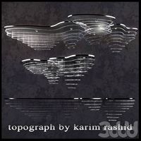
The topograph chandelier by Karim Rashid
... от карима рашида.
the topograph chandelier by karim rashid.http://www.karimrashid.com/projects#category_4/project_247
3d_export
$25
scale relief topographic world map
...ve also added the renderings both with and without texture, so that you will notice that it is done in detail.<br>enjoy it.
3d_export
$50
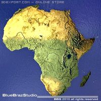
Africa 3D Model
...3dexport africa map terrain elevation satellite landscape mountain land topographic dem africa 3d model braz 21501...
3d_export
$50
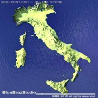
Italy 3D Model
...3dexport italy map terrain elevation satellite landscape mountain land topographic dem italy 3d model braz 21511...
3d_export
$50
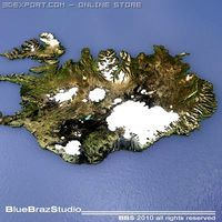
Iceland 3D Model
...3dexport iceland map terrain elevation satellite landscape mountain land topographic dem iceland 3d model braz 21509...
3d_export
$50
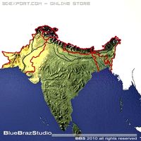
India 3D Model
...3dexport india map terrain elevation satellite landscape mountain land topographic dem india 3d model braz 21510...
3d_export
$50
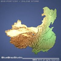
China 3D Model
...3dexport china imap terrain elevation satellite landscape mountain land topographic dem china 3d model braz 21505...
3d_export
$50
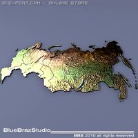
Russia 3D Model
...3dexport russia map terrain elevation satellite landscape mountain land topographic dem russia 3d model braz 21513...
3d_export
$50
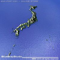
Japan 3D Model
...3dexport japan imap terrain elevation satellite landscape mountain land topographic dem japan 3d model braz 21508...
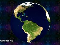
Map
3d_ocean
$5

Map
...map
3docean
geography map ocean travel world world map
a world map
3d_ocean
$5

Old Map
...old map
3docean
dirty map ocean old map paper pirates rotten travel world map
an old map
turbosquid
$3

Map
... available on turbo squid, the world's leading provider of digital 3d models for visualization, films, television, and games.
3d_ocean
$3

Map of Iran
...map of iran
3docean
flag iran map outline
an outline map of iran
3d_ocean
$2

Map of the USA
...map of the usa
3docean
america flag globe map united states usa
an outline map of the usa
3ddd
$1

Abstract Maps
... город , picture
abstract maps by artist jazzberry blue
3d_ocean
$5

Honduras Map
...honduras map
3docean
3d cinema4d honduras map mapa
honduras map designed in cinema 4d r17
3d_ocean
$2

Map of Germany
...map of germany
3docean
black country europe germany gold map outline red yellow
a simple outline map of germany
3d_ocean
$2

Map of Australia
...map of australia
3docean
australia banner country down under earth flag globe map ocean south
an outline map of australia
3d_ocean
$2

Map of Russia
...of russia
3docean
asia banner earth europe flag globe map russia russian federation siberia sovjet union
an outline map of russia