Thingiverse
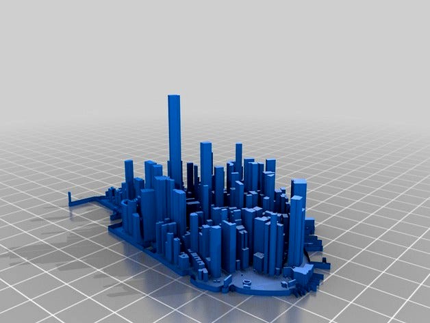
Lower Manhattan Cityscape by MTORO003
by Thingiverse
Last crawled date: 3 years ago
This is a 3D model of Lower Manhattan, New York City, United States.
Three publicly-available, fully-open-access geospatial datasets were downloaded, compiled, and minimally processed to produce this model:
New York City Building Footprints -- NYC Open Data
New York City Community Districts -- NYC Open Data
New York State 1 Meter Digital Elevation Model (DEM) -- NYS Orthos Online
Data were downloaded on October 12, 2016 and were the most current data available for those geographic features on that date.
The open source geographic information systems (GIS) software platform QGIS, along with its open source plugin, Qgis2threejs, were used to process, manipulate, and ultimately produce the model.
Building footprints were vertically exaggerated by a magnitude of three (x 3).
More photos and additional basic details on this model are available at:
https://matthewtoro.com/2016/10/24/lower-manhattan-cityscape-3d-printing/
Similar models
cg_trader
$65

Manhattan Island Cityscape
...he mouth of the hudson river, the borough is conterminous with new york county, an original county of the u.s. state of new york.
cg_trader
$20

Building 3D Model
...pple ny america usa nyc state architectural details door window fbx new york ny city city building city fbx new york nyc building
cg_trader
$299

New York - Lower Manhattan
...is exact and accurate to scale 3d city model of lower manhattan - downtown - new york and its surrounding area based on gis data
cg_trader
$100

New York City Model
...y landscape marina architectural engineering city building city landscape modern building modern city nyc building rhino building
cg_trader
$79

City 27
...et new exterior street exterior city street city scape city scene city street exterior house house exterior new york street scene
3dwarehouse
free

Empire State Building
...dwarehouse
empire state building, nyc, amerika, esc, new, york, city, #amerika #city #empire_state_building #esc #new #nyc #york
cg_trader
$25

Lower Manhattan Cityscape- 3ds and obj
... the buildings are not textured. city cityscape exterior architecture urban scene environment buildings city buildings city scene
3dwarehouse
free

Alpha Cube World -- New York City Styled Cityscape Part 1
...se
new york city styled is also worked on chicago #cubeworld #new #york #city #nyc #state #the #united #states #of #america #usa
cg_trader
$30

NYC Midtown Manhattan East
...n broadway ny apartment exterior apartment building city building city buildings city skyline new york nyc building nyc buildings
3d_export
$85

Manhattan Island Cityscape 3D Model
...el
3dexport
new york city landscape buildings exterior architecture
manhattan island cityscape 3d model digimation 74461 3dexport

Manhattan
3ddd
$1

EICHHOLTZ / Manhattan
...eichholtz / manhattan
3ddd
eichholtz
eichholtz lamp manhattan
3ddd
$1

JNL, Manhattan
... стеллаж
jnl, manhattan 300*40http://www.jnl.ru/product.aspx?family=console&product;=manhattan
3ddd
$1

TURRI / MANHATTAN
...turri / manhattan
3ddd
turri
диван manhattan от turri,текстуры в файле.
3ddd
$1

MLE Manhattan
...mle manhattan
3ddd
mle
бра производителя освещения для отелей mle manhattan
3ddd
$1

Диван Alberta Manhattan
...a manhattan
3ddd
alberta , manhattan
модульный диван manhattan.
фабрика alberta salotti.
3ddd
$1

FromItalia / Manhattan
...ddd
formitalia , fromitalia
fromitalia кресло "manhattan" размеры 114.5/95 h85
turbosquid
$500

Lower Manhattan
...squid
royalty free 3d model lower manhattan for download as on turbosquid: 3d models for games, architecture, videos. (1488281)
turbosquid
$4

Manhattan Lamp
...uid
royalty free 3d model manhattan lamp for download as max on turbosquid: 3d models for games, architecture, videos. (1285975)
turbosquid
$45

Bank of Manhattan
...ty free 3d model bank of manhattan for download as ma and obj on turbosquid: 3d models for games, architecture, videos. (1250531)
turbosquid
$6

Manhattan Chair
...ee 3d model manhattan chair for download as max, fbx, and obj on turbosquid: 3d models for games, architecture, videos. (1651633)
Cityscape
turbosquid
$200

Cityscape
...d
royalty free 3d model cityscape for download as ma and fbx on turbosquid: 3d models for games, architecture, videos. (1172119)
turbosquid
$18

Cityscape
...ree 3d model cityscape for download as 3ds, max, obj, and fbx on turbosquid: 3d models for games, architecture, videos. (1364476)
turbosquid
$6

Cityscape
...e 3d model cityscape for download as blend, fbx, dae, and obj on turbosquid: 3d models for games, architecture, videos. (1668948)
turbosquid
$200

Cityscapes
... available on turbo squid, the world's leading provider of digital 3d models for visualization, films, television, and games.
turbosquid
$69

Cityscape
... available on turbo squid, the world's leading provider of digital 3d models for visualization, films, television, and games.
turbosquid
$229

Honolulu Cityscape
...
royalty free 3d model honolulu cityscape for download as max on turbosquid: 3d models for games, architecture, videos. (1460966)
turbosquid
$49

Cityscape diorama
...
royalty free 3d model cityscape diorama for download as fbx on turbosquid: 3d models for games, architecture, videos. (1485432)
turbosquid
$45

Futuristic Cityscape
... available on turbo squid, the world's leading provider of digital 3d models for visualization, films, television, and games.
turbosquid
$30

CityScape Futuristic
... available on turbo squid, the world's leading provider of digital 3d models for visualization, films, television, and games.
3d_export
$25

Cityscape 3D Model
...l
3dexport
exterior scene city urban vray house building quarter cityscape town elements
cityscape 3d model poops 101253 3dexport
Lower
turbosquid
$500
Lower Manhattan
...squid
royalty free 3d model lower manhattan for download as on turbosquid: 3d models for games, architecture, videos. (1488281)
turbosquid
$12

Lower Back
... available on turbo squid, the world's leading provider of digital 3d models for visualization, films, television, and games.
3d_ocean
$5

Lower Floor table
...lower floor table
3docean
floortable lower
created in 3dsmax2011/vray1.5 and available in all multiple formats.
3d_export
$6

ar-15 lower receiver
...ar-15 lower receiver
3dexport
ar15 lower receiver
3d_export
$19

Lower back machine
...lower back machine
3dexport
turbosquid
free

Upper and Lower Teeth
...ree 3d model upper and lower teeth for download as ma and obj on turbosquid: 3d models for games, architecture, videos. (1636970)
turbosquid
$100

Lower Manhattan Model
... available on turbo squid, the world's leading provider of digital 3d models for visualization, films, television, and games.
turbosquid
$18
Lower Second Premolar
... available on turbo squid, the world's leading provider of digital 3d models for visualization, films, television, and games.
turbosquid
$18

Lower First Premolar
... available on turbo squid, the world's leading provider of digital 3d models for visualization, films, television, and games.
turbosquid
$18

Lower Leteral Incisor
... available on turbo squid, the world's leading provider of digital 3d models for visualization, films, television, and games.