CG Trader
Lagos
by CG Trader
Last crawled date: 1 year, 10 months ago
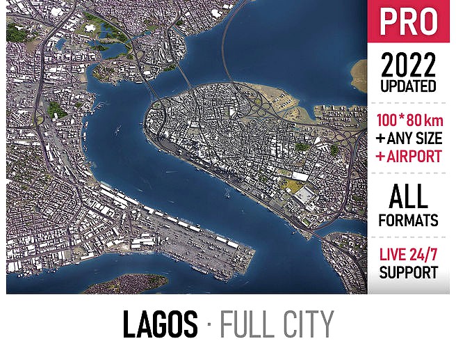
Coordinate reference system: WGS 84 / UTM zone 31N (EPSG:32631) Scene size: up to 100 x 80 km Data used: June 2022 SEND US A MESSAGE BEFORE YOU BUY Get FREE sample model Customization requests Any scene size (custom area crop) Any coordinate reference system Various levels of detail (LODs) Update to the latest data Flexible pricing (select only the options you need) PACKAGE CONTENTS This product includes scenes of various sizes and formats File formats (software supported) MAX - Autodesk 3dsMax FBX, OBJ, DAE - Exchange Formats GLTF, GLB - Games, Web, AR/VR (request) UNITYPACKAGE - Unity 3D 3DM - Rhino 3D SKP - SketchUp RVT - Autodesk Revit (request) STL - 3D Print (request) C4D - Cinema4D BLEND - Blender MA, MB - Autodesk Maya DWG, DXF - Autodesk AutoCAD BASIC OPTIONS (included with the purchase) KEY BENEFITS 24/7 customer support Regular updates and improvements High-resolution surface texture (1 meter resolution satellite image) Buildings, landuse areas, roads and railways split by type (layers / named objects) The surface is flat, easy to add details and edit geometry (terrain on request) Realistic low-poly trees and forests (max, fbx included, other formats on request) Product is ready to render out-of-the-box (3ds Max + Corona Renderer) PRESENTATION IMAGES 4K high-resolution realistic renderings (refer to images for level of detail or request close-ups) Rendered in 3dsMax (other software requires its own rendering settings) MATERIALS Trees, vegetation, landuse and airport surface with the textures assigned Buildings are UVW mapped, split by material IDs, no textures assigned CUSTOM OPTIONS (available at a special price - please request before buying) TOPOGRAPHY TERRAIN Up to 30 meter accuracy raw terrain object (SRTM v3) Multiple LODs optimized for the best polycount/details balance Contour lines (up to 1 meter interval) High-resolution (up to 20cm accuracy) satellite or surface texture Buildings and roads placed on the optimized terrain OTHER EXTRAS On-demand custom update Crop to custom area size or slice to tiles Procedural textures assigned to all buildings Individual buildings and streets (with address and/or name) Administrative boundaries of all levels (named polygons or outlines) Road and railway splines for traffic animation Public transport stops with names city map area building skyline sketchup model center landscape topography suburb neighborhood downtown skyscraper airport street park rhino lagos nigeria exterior cityscape
Similar models
cg_trader
$399

Toronto
...port skyline suburb town downtown toronto map area scene sketchup center topography landscape park city street exterior cityscape
cg_trader
$399

Kuwait
...downtown center building map area skyscraper park scene country roads street model skyline topography sketchup exterior cityscape
cg_trader
$399

Montreal
... residential area downtown montreal suburb landmark map center landscape topography neighborhood park sketchup exterior cityscape
cg_trader
$399

Berkeley
...ding center skyline landscape topography suburb neighborhood downtown airport urban street park sketchup rhino exterior cityscape
cg_trader
$399

Berlin
...dential area berlin germany center skyscraper landscape scene square environment sketchup map model topography exterior cityscape
cg_trader
$399

Dubai
...ubai uae skyscraper downtown map city area center scene skyline sketchup landscape topography urban park rhino exterior cityscape
cg_trader
$399

Fremantle
...rea building center skyline landscape topography suburb downtown airport urban street park sketchup rhino port exterior cityscape
cg_trader
$399

Perth
...ography suburb neighborhood downtown skyscraper airport urban street park sketchup perth australia city street exterior cityscape
cg_trader
$399

Baghdad
...kyline landscape topography suburb neighborhood downtown airport urban street park sketchup rhino baghdad iraq exterior cityscape
cg_trader
$399

Hong Kong
...kyline residential area hong kong shenzhen china downtown map center landscape topography suburb park sketchup exterior cityscape
Lagos
3ddd
$1

Lago Steps
...lago steps
3ddd
lago
lago steps chair.
design_connected
$16

Lago
...lago
designconnected
driade lago chairs computer generated 3d model. designed by philippe starck.
3ddd
$1

LAGO Lastika
...lago lastika
3ddd
lago
стул lago lastika
85x90x35/72h
3ddd
$1

LAGO MORGANA
...lago morgana
3ddd
тумба , lago
модульная тумба lago morgana
3ddd
$1

LAGO / NET
...lago / net
3ddd
lago , стеллаж
lago net comp 57
3ddd
$1

Woessner Lago
...woessner lago
3ddd
wossner
woessner lago
3ddd
$1

Lago Mobili vc150
...lago mobili vc150
3ddd
lago mobili
lago mobili vc150
3ddd
$1

Lago Justmat
...lago justmat
3ddd
lago
кровать justmat из италии фабрики lago.
размеры:
ширина 160 cm
длинна 240 cm
высота 80 cm
3ddd
$1

LAGO LAVABO INBILICO
...lago lavabo inbilico
3ddd
lago , lavabo inbilico
italian brend lago . milano
3ddd
$1

Lago Di Garda
...garda , serenissima
существующий гарнитур в одной из возможных комплектаций, без текстур