CG Trader
Hamilton
by CG Trader
Last crawled date: 1 year, 6 months ago
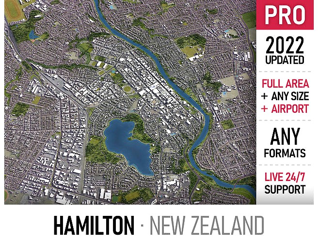
Coordinate reference system: NZGD49 / North Island Grid (EPSG:27291) Scene size: up to 60 x 60 km Units: Meters Scale: 1 : 1 Data used: October 2022 SEND US A MESSAGE Get FREE sample model Flexible pricing and discounts Customization and adjustments Any scene size (custom area crop) Any coordinate reference system Various levels of detail (LODs) Update to the latest data PACKAGE CONTENTS This product includes scenes of various sizes and formats File formats (software supported) MAX - Autodesk 3dsMax FBX, OBJ, DAE - Exchange Formats GLB, GLTF - Games, Web, AR/VR UNITYPACKAGE - Unity 3D 3DM - Rhino 3D SKP - SketchUp RVT - Autodesk Revit STL - 3D Print (request) C4D - Cinema4D BLEND - Blender MA, MB - Autodesk Maya DWG, DXF - Autodesk AutoCAD BASIC OPTIONS (included with the purchase) KEY BENEFITS 24/7 customer support Regular updates and improvements High-resolution surface texture (1 meter resolution satellite image) 100% buildings coverage from buildings footprint polygon geometries Buildings, landuse areas, roads and railways split by type (layers / named objects) The surface is flat, easy to add details and edit geometry (terrain on request) Realistic low-poly trees and forests (max, fbx included, other formats on request) Product is ready to render out-of-the-box (3ds Max + Corona Renderer) PRESENTATION IMAGES 4K high-resolution realistic renderings (refer to images for level of detail) Rendered in 3dsMax (other software requires its own rendering settings) MATERIALS Trees, vegetation, landuse and airport surface with the textures assigned Buildings are UVW mapped, split by material IDs, no textures assigned CUSTOM OPTIONS TOPOGRAPHY TERRAIN Up to 1 meter accuracy raw terrain object (National Elevation LiDAR DEM 2019) Multiple LODs optimized for the best polycount/details balance Contour lines (up to 1 meter interval) High-resolution (up to 20cm accuracy) satellite or surface texture Buildings and roads placed on the optimized terrain Starting from $999 OTHER EXTRAS Custom on-demand update Crop to custom area size or slice to tiles Procedural textures assigned to all buildings Individual buildings and streets (with address and/or name) Administrative boundaries of all levels (named polygons or outlines) Road and railway splines for traffic animation Public transport stops with names Extra charge, ask before purchase city map model area building center skyline landscape topography suburb neighborhood downtown urban street park sketchup rhino new zealand waikato exterior cityscape
Similar models
cg_trader
$299

Tbilisi Airport
...irport runway terminal building city concourse gateway facility passenger hangar gate skywalk plane hub modern exterior cityscape
cg_trader
$199

Bern Airport
...irport runway terminal building city concourse gateway facility passenger hangar gate skywalk plane hub modern exterior cityscape
cg_trader
$299

Tucson Airport
...al airport runway terminal building city concourse gateway facility passenger hangar gate skywalk plane hub modern tucson arizona
cg_trader
$299

Tromso Airport
...tional runway terminal building city concourse gateway facility passenger hangar gate skywalk plane hub modern exterior cityscape
cg_trader
$399

Kuwait
...downtown center building map area skyscraper park scene country roads street model skyline topography sketchup exterior cityscape
cg_trader
$399

Toronto
...port skyline suburb town downtown toronto map area scene sketchup center topography landscape park city street exterior cityscape
cg_trader
$399

Montreal
... residential area downtown montreal suburb landmark map center landscape topography neighborhood park sketchup exterior cityscape
cg_trader
$399

Berkeley
...ding center skyline landscape topography suburb neighborhood downtown airport urban street park sketchup rhino exterior cityscape
cg_trader
$399

Berlin
...dential area berlin germany center skyscraper landscape scene square environment sketchup map model topography exterior cityscape
cg_trader
$399

Dubai
...ubai uae skyscraper downtown map city area center scene skyline sketchup landscape topography urban park rhino exterior cityscape
Hamilton
design_connected
$29

Hamilton
...hamilton
designconnected
west elm hamilton computer generated 3d model.
3ddd
free

Minotti Hamilton
...minotti hamilton
3ddd
minotti , угловой
minotti hamilton
3ddd
$1

Porada Hamilton
...porada hamilton
3ddd
porada , hamilton
комод с выдвижными ящиками, тумба
3ddd
free

Minotti Hamilton Sets
...on , угловой , журнальный
minotti hamilton sets
3ddd
$1

BoConcept Кресло Hamilton
...ло hamilton
3ddd
boconcept , hamilton
boconcept кресло hamilton
материалы corona render.
3ddd
free

LUDVIG, Hamilton
...нция
дизайнер: fabian pellegrinet conte
описание: armchair/кресло
сайт:http://www.hamiltonconte.com/
текстуры в архиве.
design_connected
$18

Hamilton Armchair
...hamilton armchair
designconnected
boconcept hamilton armchair computer generated 3d model. designed by pedersen, henrik.
3ddd
free

Atom - Hamilton High
...atom - hamilton high
3ddd
atom , hamilton
v-ray
turbosquid
$249

Hamilton Galileo
...d
royalty free 3d model hamilton galileo for download as max on turbosquid: 3d models for games, architecture, videos. (1157029)
turbosquid
$249

Hamilton Raphael
...d
royalty free 3d model hamilton raphael for download as max on turbosquid: 3d models for games, architecture, videos. (1158168)