CG Trader
Hamilton - Ontario
by CG Trader
Last crawled date: 1 year, 10 months ago
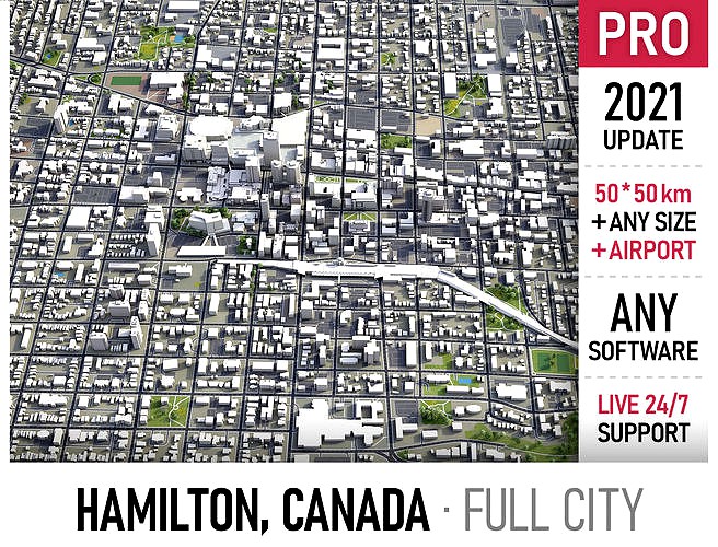
This is exact and accurate to scale 3D city model of Hamilton, Ontario and its surrounding area based on GIS data (February 2021) File units: Meters Scale: 1:1 PACKAGE CONTENTS This collection includes scenes of various sizes / formats Complete scene (city and surrounding area) Full city extents, downtown or airport You may request any specific area size (please enquire before buying) FORMATS INCLUDED MAX - Autodesk 3dsMax FBX, OBJ, DAE - Exchange Formats GLTF, GLB - Games, Web, AR/VR (request) UNITYPACKAGE - Unity 3D 3DM - Rhino 3D SKP - SketchUp RVT - Autodesk Revit (request) STL - 3D Print (request) C4D - Cinema4D BLEND - Blender MA, MB - Autodesk Maya DWG, DXF - Autodesk AutoCAD PRODUCT INFO KEY BENEFITS Live 24/7 support Buildings, landuse areas, roads and railways split by type (see scene structure) The surface is flat, easy to add details and edit geometry (terrain on request) Realistic low-poly trees and forests (max, fbx included, other formats by request) Product is ready to render out-of-the-box (3dsmax + corona renderer) EXTRAS (for a surcharge, please enquire before buying) Crop to custom area size or slice to tiles Procedural textures assigned to all buildings Topography terrain (up to 1 meter accuracy, several LODs, optimized) Individual buildings and streets (with address and/or name) Any coordinate system (Transverse Mercator projection by defaut) Administrative boundaries of all levels (named polygons or outlines) Road and railway splines for traffic animation Public transport stops with names PRESENTATION IMAGES 4K high-resolution realistic renderings (refer to images for level of detail) Rendered in 3dsMax (other softwares requires its own rendering settings) MATERIALS Buildings are UVW mapped, split by material IDs, no textures assigned Trees, vegetation, landuse and airport surface with the textures assigned SCENE STRUCTURE - model is organized by layers, all objects split by type and named properly BUILDINGS residential commercial industrial public sports parkings transport ROADS highways primary secondary tertiary residential service RAILWAYS train city tram subway monorail PAVEMENT sidewalk footway cycleway LANDUSE residential public industrial construction agriculture VEGETATION forest grass scrub park garden cemetery recreation NATURAL land sea lake river AIRPORT building (terminal, gates) apron taxiway runway SUPPORT - please send us a message 24/7 FREE - Product update with the latest GIS data (please request before the purchase) $299+ - Add topography terrain (up to 1 meter accuracy, several LODs, optimized) city map model area building center skyline landscape topography suburb neighborhood downtown skyscraper airport street park sketchup hamilton ontario canada exterior cityscape street exterior city street city building city landscape city map city skyline city street
Similar models
cg_trader
$299

Vladivostok - city and surroundings
...sketchup exterior cityscape street exterior city street city building city landscape city map city scene city street street scene
cg_trader
$299

Lipetsk
...chup lipetsk russia exterior cityscape street exterior city street city building city landscape city map city skyline city street
cg_trader
$299

Victoria
...hup victoria canada exterior cityscape street exterior city street city building city landscape city map city skyline city street
cg_trader
$299

Coquitlam
...reet park vancouver exterior cityscape street exterior city street city building city landscape city map city skyline city street
cg_trader
$299

Omsk - city and surroundings
...t exterior city street city building city landscape city map city scene city skyline city street industrial building street scene
cg_trader
$399

San Jose - Costa Rica
...extents street park sketchup exterior cityscape street exterior city street city building city landscape city skyline city street
cg_trader
$299

Novosibirsk - city and surroundings
...rior cityscape street exterior city street city building city landscape city map city scene city skyline city street street scene
cg_trader
$299

Hamilton
...land exterior cityscape street exterior city street city building city landscape city map city skyline city street rhino building
cg_trader
$299

Samara - city and surroundings
...sketchup exterior cityscape street exterior city street city building city landscape city map city scene city street street scene
cg_trader
$299

Perm - city and surroundings
...sketchup exterior cityscape street exterior city street city building city landscape city map city scene city street street scene
Hamilton
design_connected
$29

Hamilton
...hamilton
designconnected
west elm hamilton computer generated 3d model.
3ddd
free

Minotti Hamilton
...minotti hamilton
3ddd
minotti , угловой
minotti hamilton
3ddd
$1

Porada Hamilton
...porada hamilton
3ddd
porada , hamilton
комод с выдвижными ящиками, тумба
3ddd
free

Minotti Hamilton Sets
...on , угловой , журнальный
minotti hamilton sets
3ddd
$1

BoConcept Кресло Hamilton
...ло hamilton
3ddd
boconcept , hamilton
boconcept кресло hamilton
материалы corona render.
3ddd
free

LUDVIG, Hamilton
...нция
дизайнер: fabian pellegrinet conte
описание: armchair/кресло
сайт:http://www.hamiltonconte.com/
текстуры в архиве.
design_connected
$18

Hamilton Armchair
...hamilton armchair
designconnected
boconcept hamilton armchair computer generated 3d model. designed by pedersen, henrik.
3ddd
free

Atom - Hamilton High
...atom - hamilton high
3ddd
atom , hamilton
v-ray
turbosquid
$249

Hamilton Galileo
...d
royalty free 3d model hamilton galileo for download as max on turbosquid: 3d models for games, architecture, videos. (1157029)
turbosquid
$249

Hamilton Raphael
...d
royalty free 3d model hamilton raphael for download as max on turbosquid: 3d models for games, architecture, videos. (1158168)
Ontario
3ddd
free

Ontario
...ontario
3ddd
ontario , угловой
текстуры в комплекте.
polys: 391 693
verts: 227 208
3d_export
free

chair ontario
...chair ontario
3dexport
leather chair ontario
turbosquid
$7

Ontario
... available on turbo squid, the world's leading provider of digital 3d models for visualization, films, television, and games.
3ddd
free

Кровать Ontario
...ть ontario
3ddd
dream land , круглая
кровать ontario
модель предоставлана производителем
3ddd
$1

Диван Ontario
... угловой , модульный
производитель möbel&zeit;
коллекция interior
модель ontario
3d_export
$10

ontario
...ontario
3dexport
3dsmax 2015<br>3dsmax 2018<br>obj
turbosquid
$25

ONTARIO LAMP
... available on turbo squid, the world's leading provider of digital 3d models for visualization, films, television, and games.
turbosquid
$16

Flexform Ontario Sofa
...yalty free 3d model flexform ontario sofa for download as max on turbosquid: 3d models for games, architecture, videos. (1618245)
3ddd
$1

BRW Ontario
...brw ontario
3ddd
brw
набор - диван, полки, шкафчики, платяной шкаф, рабочий стол, комод
turbosquid
$99

London-Ontario-Tower
... available on turbo squid, the world's leading provider of digital 3d models for visualization, films, television, and games.