Sketchfab

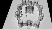
Fort Louvois ile Oleron, Chapus
by Sketchfab
Last crawled date: 1 year, 1 month ago
Fort Louvois, which is known locally as Fort Chapus or Fort du Chapus, is a fortification built between 1691 and 1694, during the reign of Louis XIV, on the Chapus islet, and is about 400 metres offshore in the town of Bourcefranc-le-Chapus in the department of Charente-Maritime, France. The fort sits opposite the citadel of Château d’Oléron on the island of Oléron. The fort was positioned so that a crossfire from the château and the fort would control the Pertuis de Maumusson (Passage of Maumusson) and impede access to the Rochefort roads from the south. Fort Louvois only saw action towards the end of World War II when bombardment greatly damaged the fort, necessitating later restoration.
Since 1972 the fort has been the site of a museum of oyster farming, and there are oyster beds next to the causeway that joins the fort to the shore. The fort also houses a permanent exhibition that describes the history of the fort and that contains models of fortifications on the Charente coast.
Source: Wikipedia.org - Fort Louvois ile Oleron, Chapus - Buy Royalty Free 3D model by LibanCiel
Similar models
3dwarehouse
free

Fort boyard V1
...ue #charentes #charentes_maritime #chateau #château #fort #fortification #france #ile_doléron #ilé_daix #monument #oleron #vauban
3dwarehouse
free

Le Château d'Oleron
...le château d'oleron
3dwarehouse
c'est le château d'oléron.
3dwarehouse
free

Château Fort
...château fort
3dwarehouse
château fort, exercice #château_fort #forteresse #fortification #moyenâge #médiéval #tour
3dwarehouse
free

invention d'un chateau fort
...on d'un chateau fort pres de l'ile d'oleron #chateau #chateaux #château #châteaux #fort #forts #invention #inventions
3dwarehouse
free

Phare de Chassiron - V 0.2
... dans les eaux du pertuis d'antioche. #atlantique #charente #charente_maritime #chassiron #france #ile #oleron #oléron #phare
3dwarehouse
free

Fort Boyard
..., chaque été, un grand feu d'artifice est tiré depuis le bâtiment. #aix #boyard #charente #fort #france #maritime #oléron #ré
3dwarehouse
free

château fort
...château fort
3dwarehouse
château fort
3dwarehouse
free

château fort
...château fort
3dwarehouse
château fort #château_fort
3dwarehouse
free

Château fort
...château fort
3dwarehouse
château fort avec pont levis #château #château_fort #pont_levis
3dwarehouse
free

Château Fort
...château fort
3dwarehouse
château fort, bien armée
Louvois
cg_trader
free

1 rue Louvois Viroflay
... with vray 3.00 building at 1 rue louvois; residence. louvois street viroflay building rue louvois exterior other street exterior
3dwarehouse
free

Fountaine Louvois Paris
...fountaine louvois paris
3dwarehouse
3dwarehouse
free

1 rue Louvois, Viroflay
...1 rue louvois, viroflay
3dwarehouse
bâtiment au 1 rue louvois; résidence. #rue_louvois #viroflay
3dwarehouse
free

LA FONTAINE LOUVOIS-PARIS, FR
... octogonal, et dont les évents lancent en avant 8 jets d'eau paraboliques. - #europa #europe #fontaine #france #frança #paris
3dwarehouse
free

Pont Royal
...the king who gave it the name pont royal. louvois director of the bâtiments du roi, charged jacques gabriel,...
Chapus
cg_trader
$20

King Chappa - Dragon Ball | 3D
...eight-handed technique. he lives at the address ssr 249905 c with his wife ruhna and their three children sapa, peruka and chapu.
3dwarehouse
free

casa chapu
...casa chapu
3dwarehouse
chapultepec
3dwarehouse
free

Porte char Chapus michel
...porte char chapus michel
3dwarehouse
porte char entreprise chapus michel
3dwarehouse
free

Semi remorque Chapus Michel
...semi remorque chapus michel
3dwarehouse
3dwarehouse
free

CHapUr
...chapur
3dwarehouse
centro comercial chapu prolongacion montejo
3dwarehouse
free

truck with semi-trailer + Volvo Excavator
...3dwarehouse my copy of thomas d.'s model 'porte char chapus michel' whith a volvo...
3dwarehouse
free

truck with semi-trailer + asphalt paver
...my modified copy of thomas d.'s model 'porte char chapus michel' with straßenfertiger of kai...
3dwarehouse
free

hombre 3d people
... #hombre #human #humano #man #men #pasamontaña #people #person #persona servicios de modelado 3d, render y video: www.solocad.net
3dwarehouse
free

Embarcadère de Bourcefranc
...3dwarehouse au lendemain de la seconde guerre mondiale, le chapus fut choisi pour l'emplacement d'un embarcadère moderne construit en...
Oleron
thingiverse
free

Phare de Chassiron (Chassiron's Lighthouse France) by BourrinDesBois
...été réalisé par découpage par couches. https://www.qwant.com/?q=phare%20chassiron&t=images chassiron's lighthouse (oleron island, france). merci de m'envoyer vos réalisions si cela...
cg_trader
$10

oleron table houses the world
...orld
cg trader
oleron table houses the world 3d, available formats max, obj, 3ds, fbx, stl, dae, , ready for 3d animation and ot
cg_trader
$10

oleron table houses the world
...
cg trader
3d model oleron table houses the world, formats include max, obj, 3ds, fbx, stl, dae, , ready for 3d animation and ot
cg_trader
$5

Absolut Keramika Oleron Cream 800x800
...keramika oleron cream 800x800
cg trader
collection: oleron cream
manufacturer: absolut keramika
country: spain
size - 800x800 mm
cg_trader
$5

Absolut Keramika Oleron Grey 800x800
...t keramika oleron grey 800x800
cg trader
collection: oleron grey
manufacturer: absolut keramika
country: spain
size - 800x800 mm
cg_trader
$10

Oleron garden furniture Maisons du Monde
...urniture maisons du monde
cg trader
oleron garden furniture maisons du monde 3d model, available formats max obj 3ds fbx stl dae
cg_trader
$10

Parasol gray 350 OLERON houses the world
...0 oleron houses the world
cg trader
parasol gray 350 oleron houses the world 3d model, available formats max obj 3ds fbx stl dae
cg_trader
$10

Parasol ivory rect OLERON houses the world
...oleron houses the world
cg trader
parasol ivory rect oleron houses the world 3d model, available formats max obj 3ds fbx stl dae
cg_trader
$10

Parasol gray 250 OLERON houses the world
...0 oleron houses the world
cg trader
parasol gray 250 oleron houses the world 3d model, available formats max obj 3ds fbx stl dae
Fort
3d_export
$5

fort
...fort
3dexport
just cool fort
turbosquid
$8

Fort
...squid
royalty free 3d model fort for download as max and fbx on turbosquid: 3d models for games, architecture, videos. (1710880)
turbosquid
$333

fort
...quid
royalty free 3d model fort 3d model for download as fbx on turbosquid: 3d models for games, architecture, videos. (1510138)
turbosquid
free

fort
... available on turbo squid, the world's leading provider of digital 3d models for visualization, films, television, and games.
3ddd
$1

FORTE ARAMIS ARS94
...forte aramis ars94
3ddd
forte , шкаф
фабрика forte модель aramis ars94
turbosquid
$80
fort model
...bosquid
royalty free 3d model fort model for download as max on turbosquid: 3d models for games, architecture, videos. (1323270)
3d_export
$5

Fort 3D Model
...fort 3d model
3dexport
fort 3d model ig 85730 3dexport
3d_export
$15
wooden fort
...wooden fort
3dexport
wooden hamlet
turbosquid
$7

Forte 18
...alty free 3d model forte 18 for download as max, obj, and fbx on turbosquid: 3d models for games, architecture, videos. (1212521)
turbosquid
$29

The Fort(1)
... available on turbo squid, the world's leading provider of digital 3d models for visualization, films, television, and games.
Ile
3ddd
$1
IL Loft
...il loft
3ddd
il loft
мебель фирмs il loft
стул- модель tim
барная стойка-эксклюзивная модель
3ddd
$1

Il Paralume Marina
...il paralume marina
3ddd
il paralume marina
il paralume marina
3ddd
$1

Il Paralume Marina
...il paralume marina
3ddd
il paralume marina
il paralume marina
3ddd
$1

IL Paralume Marina
...il paralume marina
3ddd
il paralume marina
il paralume marina
3ddd
$1

IL Loft ASTRA
...il loft astra
3ddd
il loft
кресло il loft astra
3ddd
$1

IL Paralume Marina
...il paralume marina
3ddd
il paralume marina
il paralume marina
3ddd
$1

Il paralume marina
...il paralume marina
3ddd
598150 , il paralume marina
il paralume marina
3ddd
$1

Il Paralume Marina
...il paralume marina
3ddd
il paralume marina
bra il paralume marina
3ddd
$1

IL Paralume Marina_1214_SO
...il paralume marina_1214_so
3ddd
il paralume marina
люстра il paralume marina_1214_so
3ddd
$1

IL Loft Palace
...il loft palace
3ddd
il loft
диван, il loft, palace с разверткой