37 qgis 3d models found
Download or buy, then render or print from the shops or marketplaces.
3D Models below are suitable not only for printing but also for any
computer graphics like CG, VFX, Animation, or even CAD. You can print these 3d models on
your favorite 3d printer or render them with your preferred render engine.
Please note that the 3D model database is only a Search Engine. You should
visit the original websites. Most of the models can be easily imported and rendered
with Autodesk 3ds Max, Maya, Blender, C4D, and Sketchup. Check for online
3d model conversions tools for your file format.
thingiverse
free

QGis rod for ZED-F9P by Eisinator
...qgis rod for zed-f9p by eisinator
thingiverse
my design for an qgis rod.
thingiverse
free
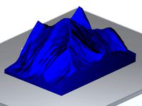
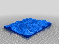
Mount Everest by gluetolf
...everest built out of data provided by viewfinderpanoramas.org. using qgis 3dem and accutrans 3d. reduced...
thingiverse
free

Mount St. Helens by sitts314
...thingiverse made with data from: http://www.viewfinderpanoramas.org/coverage%20map%20viewfinderpanoramas_org3.htm software used: qgis http://qgisorg/en/site/ heightmap2stl.jar...
thingiverse
free

Yangpyung Map Puzzle (Korean lable)
...puzzle data source: administrative boundary file from www.juso.go.kr tools: qgis for visual inspection adobe illustrator for svg exporting www.tinkercad.com...
thingiverse
free

Mount Feathertop by lockylast
...sourced from data.vic.gov.au, and converted to stl using the qgis demto3d plugin. label added with...
thingiverse
free

Teton Mountains by da429boss
...teton national park(imagery from the usgs 3dep program). used qgis demto3d tool to create the 3d model and sliced...
thingiverse
free

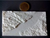
Pinnacle Mountain, Arkansas by stewardj
...is from elevation orthodata from the ned database. used qgis meshlab, and meshmixer to pull it...
thingiverse
free
Calatayud (Spain) - Jalon River Valley by talud08
...by talud08 thingiverse the stl file was created with qgis software from a mdt file, downloaded from the ign...
thingiverse
free

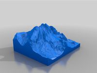
Ben Nevis 3D Terrain Model by gluetolf
...10″ w. created using opendata from https://www.ordnancesurvey.co.uk/opendatadownload/products.html and software: qgis and accutrans...
thingiverse
free

Gifford Marine Park by lockylast
...ausseabed marine portal, and converted to stl using the qgis demto3d plugin. label added with...
thingiverse
free

Mount Massive Colorado by stewardj
...up. i used usgs ned elevation data, then into qgis then meshlab, then meshmixer. this file is very large,...
thingiverse
free
Valle del Jerte (Spain) by t_crego
...obtained from lidar national geographic institute of spain. with qgis and plugin demto3d i export as .stl. this fraction...
thingiverse
free

Bolaven Plateau (Lao PDR / Laos) Topography by MTORO003
...open source plugin, demto3d, that runs on top of qgis (or on top of another open source gis platform:...
thingiverse
free

montasio by terotero
...3d model of montasio, iconic italian mountain. realized using qgis and public raw dem data. used as a positive...
thingiverse
free

civetta by terotero
...of monte civetta, iconic italian dolomite mountain. realized using qgis and public raw dem data. used as a positive...
thingiverse
free

Mt. St. Helens 1:50000 scale
...model was created by importing the raster file into qgis and using the demto3d plugin tool. i set the...
thingiverse
free

monte pelmo by terotero
...of monte pelmo, iconic italian dolomite mountain. realized using qgis and public raw dem data. used as a positive...
thingiverse
free

tre cime di lavaredo by terotero
...model of themost iconic italian dolomite mountain. realized using qgis and public raw dem data. used as a positive...
thingiverse
free

Yellow Creek Lake, Pennsylvania 3D model by NaturallyFocused256
...using usgs digital elevation model (dem) data, processed in qgis software and exported to a 3d stl file. to...
thingiverse
free
Camp Susque (Trout Run, PA) Elevation Model by malbert
...qgis (http://www.qgis.org/) -convert to rendered geotiff (see this tutorial http://maps.cga.harvard.edu/qgiswkshop/export_geotiff.php) -import into blender as plane (http://www.blender.org) -subdivide plane several...
thingiverse
free
Mount Everest 1:100000 by jawensi
...para los softwares sig gratuitos kosmo (http://www.opengis.es/) y qgis (http://www.qgisorg/en/site/) topography model of the mount everest in nepal. created...
thingiverse
free
The "Vyskoká" peak in High tatras, Slovakia by Jansvast
...bitmap from https://zbgis.skgeodesy.sk and converted it to wrml in qgis and to stl in adobe 3d reviewer. made printable...
thingiverse
free

Hawaii (Big Island) by sitts314
...multiple colors. elevation data obtained from:http://www.viewfinderpanoramas.org/coverage%20map%20viewfinderpanoramas_org3.htm created using qgis: http://www.qgisorg/en/site/ and hgt2stl:...
thingiverse
free

Matterhorn 1:30000 by jawensi
...para los softwares sig gratuitos kosmo (http://www.opengis.es/) y qgis (http://www.qgisorg/en/site/) topography model of the matterhorn in switzerland. created from...
thingiverse
free

Mars Perseverance Rover Landing Site Jezero Crater: Mars Lesson built with the "NASA Mars Trek" & QGIS by GrowFlavor
...ossibly print a matching handout with details of the discovery index keyed with the same color dot) as the science team explores.
thingiverse
free

Terrain Model of Binghamton, NY by anoved
...orthos online, tiled and converted to heightmap images with qgis and inefficiently converted to stl using my program hmstl....
thingiverse
free

Yosemite Valley 1:75000 by jawensi
...para los softwares sig gratuitos kosmo (http://www.opengis.es/) y qgis (http://www.qgisorg/en/site/) topography model of yosemite valley in the western sierra...
thingiverse
free

Naranjo de Bulnes 1:5000 by jawensi
...para los softwares sig gratuitos kosmo (http://www.opengis.es/) y qgis (http://www.qgisorg/en/site/) topography model of the pico urriellu (naranjo de bulnes)...
thingiverse
free

Sierra Nevada 1:40000 by jawensi
...para los softwares sig gratuitos kosmo (http://www.opengis.es/) y qgis (http://www.qgisorg/en/site/) topography model of sierra nevada located in granada, south...
thingiverse
free

Elevation model from a part of São Paulo by aroldorosenberg
...to visualize the terrain. i made this using a qgis shapefile and rhino. i used the patch command, so...
thingiverse
free

Australia by gaellafond
...using geoserver. this step can also be done using qgis or arcmap. i created a stl file from the...
thingiverse
free

Lower Manhattan Cityscape by MTORO003
...software platform qgis, along with its open source plugin, qgisthreejs, were used to process, manipulate, and ultimately produce the...
thingiverse
free

Training run route draped over surrounding terrain by anoved
...route map created with: http://gpxtruder.xyz terrain model created with qgis and a little special spice from digital elevation data...
thingiverse
free

Fagradalsfjall volcano Iceland relief map by Hlynur_taekjavordur
...gaps in the data. stl files were created using qgis software utilising the demto3d...
thingiverse
free

Lunar Crater Chain Mendeleev: NASA Moon Trek Chang'e 2 DEM 20m by GrowFlavor
...series of crater chain terrain models made with the qgis plugin demto3d using the ~1tb chang'e 2 .vrt 20m...
thingiverse
free

Binghamton Election District Maps by anoved
...total population counts. approximate election district areas calculated with qgis using $area / 10764000 to convert square feet to...
thingiverse
free

Topographical Push Pin Map
...program that can turn topographical data into maps, like qgis -inkscape (or other vector program like...