Thingiverse

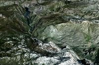
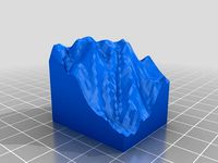
Yosemite's Royal Arch Route 3d topo by Shapespeare
by Thingiverse
Last crawled date: 3 years, 1 month ago
The Royal Arch Route is the greatest moderate climbing route in Yosemite Valley. This model is so detailed that you can see the very cracks and ledges which climbers ascend.
I made it from a LIDAR dataset available on http://opentopo.sdsc.edu/. The data was collected as part of a study of rockfall in Yosemite. Try not to think about that as you climb the cliff.
You can see my tutorial video at https://www.youtube.com/watch?v=t4-ICkvyJv0
I made it from a LIDAR dataset available on http://opentopo.sdsc.edu/. The data was collected as part of a study of rockfall in Yosemite. Try not to think about that as you climb the cliff.
You can see my tutorial video at https://www.youtube.com/watch?v=t4-ICkvyJv0
Similar models
thingiverse
free

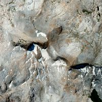
Yosemite's Royal Arch and Washington Column by Shapespeare
...sdsc.edu/. the data was collected as part of a study of rockfall in yosemite. try not to think about that as you climb the cliff.
thingiverse
free

Swan Slab Boulder (Yosemite) Climbing Hold by Shapespeare
...ot more on the 3d printing today podcast available on itunes, or stitcher radio learn more at http://www.threedprintingtoday.com/
thingiverse
free

Yosemite Valley's Cathedral Rocks by Shapespeare
...3d printing today podcast available on itunes, stitcher radio or direct from the source at http://threedprintingtoday.libsyn.com/
3dwarehouse
free

Klimhal Yosemite Zwolle
...klimhal yosemite zwolle
3dwarehouse
klimhal in zwolle #climbing #indoor_climbing #klimhal #klimmen #klimmuur #yosemite
thingiverse
free

Yosemite's Glacier Point featuring the 4-Mile trail and the Ledge Trail by Shapespeare
...the ledge route.
here is my video tutorial showing how to make 3d prints from lidar https://www.youtube.com/watch?v=t4-ickvyjv0
thingiverse
free

Yosemite's Cathedral Peak Southeast Buttress by Shapespeare
...3d printing today podcast available on itunes, stitcher radio or direct from the source at http://threedprintingtoday.libsyn.com/
thingiverse
free

Yosemite Valley's Cathedral Spires 3dTopo by Shapespeare
...3d printing today podcast available on itunes, stitcher radio or direct from the source at http://threedprintingtoday.libsyn.com/
thingiverse
free

Yosemite's Mist Trail 3d map by Shapespeare
...lected as part of a study of rockfall in yosemite.
you can see my tutorial video at https://www.youtube.com/watch?v=t4-ickvyjv0
thingiverse
free

Yosemite's Cathedral Peak super hi res by Shapespeare
...3d printing today podcast available on itunes, stitcher radio or direct from the source at http://threedprintingtoday.libsyn.com/
thingiverse
free

Yosemite Falls 3dTopo by Shapespeare
...3d printing today podcast available on itunes, stitcher radio or direct from the source at http://threedprintingtoday.libsyn.com/
Yosemite
3ddd
$1

Yosemite Acacia Nightstand
...cacia , тумба
yosemite acacia nightstand.модель в трех форматах.карты и рендер в архиве.
3ddd
$1

Yosemite Iron Diamond Mirror
...yosemite iron diamond mirror
3ddd
yosemite , diamond
yosemite iron diamond mirror
3ddd
free
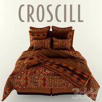
Yosemite Bedding Collection
...ное бельё , croscill
постельное бельё yosemite фирмы croscill
размер матраса 160x200 см.
3d_ocean
$25
Yosemite National Park
... river shew spectacular terrain yosemite
very high detailed higypoly part from the yosemite national park with 8192*8192 texture.
3d_export
$15

Yosemite Sam 3D Model
... model
3dexport
yosemite sam toon cartoon loony toons kid caracter high poly cute gun
yosemite sam 3d model buncic 76332 3dexport
turbosquid
$4
Triple Divide Peak - Yosemite
...ee 3d model triple divide peak - yosemite for download as fbx on turbosquid: 3d models for games, architecture, videos. (1341729)
turbosquid
$10

Buena Vista Lake Yosemite
...d model buena vista lake yosemite for download as obj and fbx on turbosquid: 3d models for games, architecture, videos. (1214984)
thingiverse
free

Yosemite
...aker 2+.
for more information on documentation, visit my school blog: http://3dprinting.illustratingmath.com/2019/09/25/yosemite/
thingiverse
free

Yosemite Valley by cepeza
...yosemite valley by cepeza
thingiverse
yosemite valley
3d_sky
$8

Yosemite Acacia Nightstand
...acia nightstand
3dsky
yosemite acacia nightstand
yosemite acacia nightstand.model three formatah.karty and render in the archive.
Shapespeare
thingiverse
free
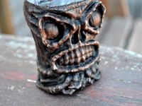
Tikithulu by Shapespeare
...sed coconut shrimp.
eldritch pu pu platters.
the mad strumming of infernal ukuleles.
dead cthulhulu orders another maitai.
thingiverse
free

Crater Lake 3dtopo by Shapespeare
...on how to make models from digital elevation data can be found on my blog at
http://www.the3dprintedfuture.com/shapespeare/?p=1
thingiverse
free

Kilimanjaro by Shapespeare
...he "collectible mountain" version which includes the bast down to sea level see http://www.thingiverse.com/thing:239792
thingiverse
free

Alexander the Printable by Shapespeare
...w.thingiverse.com/thing:239407 and added a base to make it printable with an extruder bot. pretty amazing for a cell phone scan!
thingiverse
free

Pig Skull Sense3d scan by Shapespeare
...by shapespeare
thingiverse
this is what was inside http://www.thingiverse.com/thing:224314 . the rest is headcheese yummmm. . .
thingiverse
free

Tuolumne Meadows to Mt Lyell 3d Topo by Shapespeare
...tuolumne meadows to mt lyell 3d topo by shapespeare
thingiverse
3d topo for zachary
thingiverse
free

Kirkwood lift map by Shapespeare
...wood ski area showing all the lifts in contrasting color. there is a single color version for you single extruder folks as well.
thingiverse
free
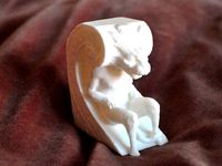
Biltmore Gargoyle by Shapespeare
...florida. he kind of reminds me of harry potter's house elf dobby.
it isn't often you can get that close to a gargoyle.
thingiverse
free

Monument Valley 3d map by Shapespeare
...s on how to make models from digital elevation data can be found on my blog at http://www.the3dprintedfuture.com/shapespeare/?p=1
thingiverse
free

Cathedral range topo by Shapespeare
...on how to make models from digital elevation data can be found on my blog at
http://www.the3dprintedfuture.com/shapespeare/?p=1
Topo
turbosquid
free
Tech Lighting Topo
...ree 3d model tech lighting topo for download as max and blend on turbosquid: 3d models for games, architecture, videos. (1433178)
3d_ocean
$8
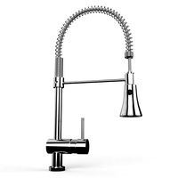
Spring Faucet
...accurate, based on real product, detailed and with nice topo.. ...
cg_studio
$79

The Grand Canyon in Arizona United States High Poly3d model
...polygon uv mapped detailed precise exact photo realistic topo toporaphical landscape desert elevation model rocks canyon elevation map .vue...
3d_export
$45

Azteca Mexico Yellow Black FIFA World Cup 1986 Match Ball
...native 3dsmax 2014 - obj - fbx - dae topo - increased polycount around holding edges and uv seams...
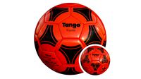
3d_export
$45

Tango Espana White Black FIFA World Cup 1982 Match Ball
...native 3dsmax 2014 - obj - fbx - dae topo - increased polycount around holding edges and uv seams...
3d_export
$45
Tango Espana Orange Black FIFA World Cup 1982 Match Ball
...native 3dsmax 2014 - obj - fbx - dae topo - increased polycount around holding edges and uv seams...
3d_export
$45

Tango Italia UEFA European Football Championship 1980 Match Ball
...native 3dsmax 2014 - obj - fbx - dae topo - increased polycount around holding edges and uv seams...
3d_export
$45

Azteca Mexico White Black FIFA World Cup 1986 Match Ball
...native 3dsmax 2014 - obj - fbx - dae topo - increased polycount around holding edges and uv seams...
3d_export
$45

Tango Gol Blue FIFA 1988 Match Ball
...native 3dsmax 2014 - obj - fbx - dae topo - increased polycount around holding edges and uv seams...
thingiverse
free
topo by tabatha23
...topo by tabatha23
thingiverse
topo
Route
turbosquid
$10

ROUTES~1.3DS
... available on turbo squid, the world's leading provider of digital 3d models for visualization, films, television, and games.
turbosquid
$46

Task Chair - Route
...del task chair - route for download as max, 3ds, fbx, and obj on turbosquid: 3d models for games, architecture, videos. (1644066)
turbosquid
$10

ROUTES~1.DXF
... available on turbo squid, the world's leading provider of digital 3d models for visualization, films, television, and games.
turbosquid
$10

ROUTES~1.LWO
... available on turbo squid, the world's leading provider of digital 3d models for visualization, films, television, and games.
3d_export
$65

eighth route army
...eighth route army
3dexport
simple rendering of the scene file
3d_export
$65

eighth route army
...eighth route army
3dexport
simple rendering of the scene file
turbosquid
$6
![Alternative route [traffic signal]](/t/13301445.jpg)
Alternative route [traffic signal]
... model alternative route [traffic signal] for download as max on turbosquid: 3d models for games, architecture, videos. (1199677)
3ddd
$1
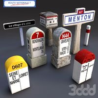
Route nationale 7
...route nationale 7
3ddd
дорожный знак
inspiration fro road signs of the nationale 7
3d_export
$6

MDF Routed Beds 3D Model
...mdf routed beds 3d model
3dexport
bed
mdf routed beds 3d model ashvathnarayana 62550 3dexport
turbosquid
$5

Route to be used by pedal cycles only
... available on turbo squid, the world's leading provider of digital 3d models for visualization, films, television, and games.
Royal
3d_export
$100

Royal
...royal
3dexport
royal 3d model
3ddd
$1
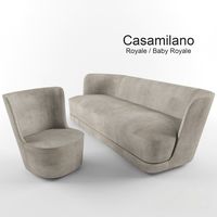
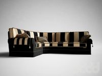
Casamilano-Royale / Baby Royale
...lano
royale / baby royale
размеры дивана:
длина 2500
глубина 1020
высота 820
размеры кресла:
длина 1000
глубина 920
высота 820
3ddd
$1
Royal
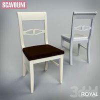
...avolini , royal
стул фабрики "skavolini"http://www.scavolini.com.ru/
3ddd
$1

Royal
...royal
3ddd
рояль
royal sdelan v 2011x maxe takje prilogsetsya 3ds i fbx.
3ddd
$1
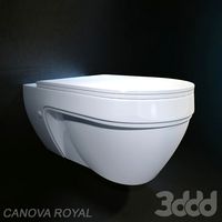
СANOVA ROYAL
...ano , сanova royal , унитаз
унитаз сanova royal
3ddd
$1
Keoma Royal
...keoma royal
3ddd
keoma , royal
диван фабрики keoma модель royal.
3ddd
$1
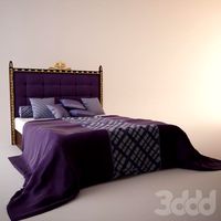
Royal Bed
...royal bed
3ddd
постельное белье , royal
royal bed king size
3d_export
$15
armchair royal
...armchair royal
3dexport
armchair royal
3d_export
$5
royal bolt
...royal bolt
3dexport
royal bolt
3ddd
$1

royall mirror
...royall mirror
3ddd
royall mirror
Arch
3d_export
free

arch
...arch
3dexport
arch
design_connected
$11
Arch
...arch
designconnected
bonaldo arch computer generated 3d model.
turbosquid
$3

arch
...ch
turbosquid
royalty free 3d model arch for download as obj on turbosquid: 3d models for games, architecture, videos. (1551270)
3d_export
$5

ruined arch
...ruined arch
3dexport
ruined arch
turbosquid
$18
Arch
...
royalty free 3d model arch for download as obj, fbx, and stl on turbosquid: 3d models for games, architecture, videos. (1338636)
turbosquid
$25

Arch
... available on turbo squid, the world's leading provider of digital 3d models for visualization, films, television, and games.
turbosquid
$16

Arch
... available on turbo squid, the world's leading provider of digital 3d models for visualization, films, television, and games.
turbosquid
free

Arch
... available on turbo squid, the world's leading provider of digital 3d models for visualization, films, television, and games.
turbosquid
free

arches
... available on turbo squid, the world's leading provider of digital 3d models for visualization, films, television, and games.
3ddd
$1

Portal/ Arch
...ортал , арка , проем
portal/ arch classic style