CG Trader

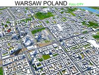
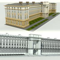
Warsaw 30x30km City Map
by CG Trader
Last crawled date: 1 year, 8 months ago
A DETAILED 3D MODEL CITY MAP OF WARSAW, POLAND: :: Scene Information :: 3dsmax 2015 V-Ray 3.60.03 LWF maps: no texture maps used shader: VRrayMtl the area is 30 x 30 km this model uses OSM data :: Geometry :: metric system [cm] layers are used (buildings, hightway, railroad, water) not all houses are included due to import restrictions or missing OSM data see preview images for covered area :: Materials :: V-Ray materials no texture maps used for this asset :: Lightsetup :: daylight system (included) :: Formats :: 3dsmax 2015 OBJ FBX city cityscape topography geography map atlas location exterior poland polen warschau warsaw warszawa landmark
Similar models
cg_trader
$149

Krakow Poland 30x30km 3D City Map
...land euro europe eu country city cityscape map topography geography cartography lost location atlas road exterior crakow landmark
cg_trader
$199

Verona Italy 30x30km 3D City Map
...tem (included) :: formats :: 3dsmax 2015
obj
fbx italy verona venice europe eu euro map city cityscape exterior landmark 3d model
cg_trader
$149
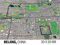
Beijing China 30x30km 3D City Map
...peking city cityscape topography geography atlas location exterior world map cartography country continent travel road china asia
cg_trader
$149

Chemnitz Germany 30x30km 3D City Map
...n germany eu euro merkel city cityscape topography geography atlas location exterior world map cartography country continent road
cg_trader
$149

Cologne Germany 30x30km 3D City Map
...tyscape topography geography map atlas location exterior landscape cologne germany german deutschland eu europe cartography koeln
cg_trader
$149

Birmingham England UK 30x30km 3D City Map
... 2015
obj
fbx birmingham uk england british britain eu pound ireland scotland queen map city cityscape europe irish exterior euro
cg_trader
$149

Bonn Germany 30x30km 3D City Map
...ax 2015
obj
fbx bonn berlin germany german city cityscape topography geography atlas location exterior eu europe euro map
cg_trader
$149

Bremen Germany 30x30km 3D City Map
...en city cityscape topography geography map atlas location exterior deutschland germany german eu euro europe merkel berlin travel
cg_trader
$149

Cottbus Germany 30x30km 3D City Map
...n germany eu euro merkel city cityscape topography geography atlas location exterior world map cartography country continent road
cg_trader
$149

Dortmund Germany 30x30km 3D City Map
...ortmund city cityscape germany german deutsch merkel berlin street highway railway travel map topography geography atlas exterior
30X30Km
cg_trader
$149

Rome 30x30km City Map
...pe vatican europe eu city cityscape topography geography country road world map location atlas ball shaped soil exterior landmark
cg_trader
$149

Toulouse 30x30km City Map
... obj fbx toulouse france french euro eu europe city cityscape topography geography map atlas location exterior landscape landmark
cg_trader
$149

Quebec 30x30km City Map
...ovince quebec cityscape topography geography atlas location exterior world map cartography country continent travel road landmark
cg_trader
$149

Pittsburgh 30x30km City Map
...ghway river landscape guidance road blueprint nature architecture sea direction cartography navigation business exterior landmark
cg_trader
$149

Strasbourg 30x30km City Map
...strasbourg strassburg france french city cityscape eu europe politics alsace euro cash coin paris madrid breton exterior landmark
cg_trader
$149

Toronto 30x30km City Map
...tario lake city cityscape map montreal usa road architecture urban business travel aerial modern water guidance exterior landmark
cg_trader
$149

Salzburg 30x30km City Map
...ia mozart europe euro eu city cityscape topography geography getreidegasse hofburg exterior sporer world map cartography landmark
cg_trader
$149
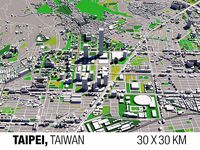
Taipei 30x30km City Map
...sa 101 cityscape republic of china geography atlas location exterior world map cartography country continent travel road landmark
cg_trader
$149

Oslo Norway 30x30km City Map
... europe eu map city cityscape norwegian ocean sea travel skyscraper house exterior euro holmenkollen oslofjord geography landmark
Warsaw
3d_export
$199
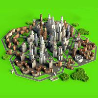
warsaw city poland 50km
...der ready. 1. suitable for games, games, education, architecture etc. 2. mainly used for town and urban planning, real estate etc
3d_export
$5

USSR Finka Knife
...army of the soviet union and a number of warsaw pact countries from 1940 to...
3d_export
$49
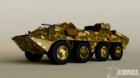
Brt70 3D Model
...armored personnel carrier military russian army russia red ukraine warsaw pact vehicle 8x8 wheeled amphibious brt70 3d model 3dsmodels...
3d_ocean
$29
Neoclassical Building
...city kprm low neoclassical poly town ujazdowskie urban urm warsaw low poly building in neoclassical style, diffuse and bump...
cg_studio
$29

Monumental Skyscraper3d model
...skyscraper3d model cgstudio castle monumental building city skyscraper communism warsaw poland russia stone high rise roman column prl culture...
cg_studio
$139

Sherman MK VC Firefly - Tryniec3d model
...firefly tryniec british 17 pounder anti-tank gun 2‘th polish warsaw armoured division italy 1945 .c4d .obj .lwo .fbx .3ds...
cg_studio
$139
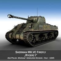
Sherman MK VC Firefly - Rycerz I3d model
...firefly rycerz british 17 pounder anti-tank gun 2‘th polish warsaw armoured division italy 1945 .c4d .obj .lwo .fbx .3ds...
3d_export
$99

uaz 469
...army, as well as in the countries of the warsaw pact, since the mid 1970s. length - 4025 mm....
3d_export
$15
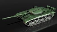
The T-72 Ural
...in service with the cis countries, exported to the warsaw pact states, finland, india, iran, iraq, syria. modifications of...
3d_export
$15
t-72 ural
...in service with the cis countries, exported to the warsaw pact states, finland, india, iran, iraq, syria. modifications of...
City
3d_export
$18
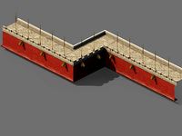
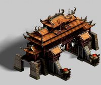
imperial city-city gate-city wall 782
...imperial city-city gate-city wall 782
3dexport
imperial city-city gate-city wall 782<br>3ds max 2015
3d_export
$18
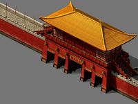
imperial city-city gate-city wall 785
...imperial city-city gate-city wall 785
3dexport
imperial city-city gate-city wall 785<br>3ds max 2015
3d_export
$40
city
...city
3dexport
a city with non-standard architecture.
design_connected
$9

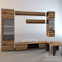
City
...city
designconnected
emmemobili city dining tables computer generated 3d model. designed by ferruccio laviani.
3ddd
$1

Диван City
...диван city
3ddd
city , softline
диван city (фирма softline)
3ddd
$1
Гостиная CITY
...гостиная city
3ddd
city , дятьково
гостиная city производства дятьково
3d_export
$18
imperial city-shabak-city wall
...imperial city-shabak-city wall
3dexport
imperial city-shabak-city wall<br>3ds max 2015
3d_export
$18
imperial city-shabak-city gate
...imperial city-shabak-city gate
3dexport
imperial city-shabak-city gate<br>3ds max 2015
turbosquid
$300

City
...ty
turbosquid
royalty free 3d model city for download as 3ds on turbosquid: 3d models for games, architecture, videos. (1235306)
turbosquid
$249

city
...ity
turbosquid
royalty free 3d model city for download as ma on turbosquid: 3d models for games, architecture, videos. (1340610)
Map
3d_ocean
$5

Map
...map
3docean
geography map ocean travel world world map
a world map
3d_ocean
$5

Old Map
...old map
3docean
dirty map ocean old map paper pirates rotten travel world map
an old map
turbosquid
$3

Map
... available on turbo squid, the world's leading provider of digital 3d models for visualization, films, television, and games.
3d_ocean
$3

Map of Iran
...map of iran
3docean
flag iran map outline
an outline map of iran
3d_ocean
$2

Map of the USA
...map of the usa
3docean
america flag globe map united states usa
an outline map of the usa
3ddd
$1

Abstract Maps
... город , picture
abstract maps by artist jazzberry blue
3d_ocean
$5

Honduras Map
...honduras map
3docean
3d cinema4d honduras map mapa
honduras map designed in cinema 4d r17
3d_ocean
$2

Map of Germany
...map of germany
3docean
black country europe germany gold map outline red yellow
a simple outline map of germany
3d_ocean
$2

Map of Australia
...map of australia
3docean
australia banner country down under earth flag globe map ocean south
an outline map of australia
3d_ocean
$2

Map of Russia
...of russia
3docean
asia banner earth europe flag globe map russia russian federation siberia sovjet union
an outline map of russia