Thingiverse

Walton-on-the-Naze by Field_Studies_Council
by Thingiverse
Last crawled date: 3 years, 1 month ago
Created from Environment Agency LIDAR Data (50cm DSM).
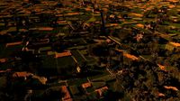
Scaled model of Walton-on-the-Naze coastline.
Created for use in Geography classroom and fieldwork with the Field Studies Council.
Designed to cover a single 1km grid square TM 2623.
Shows clearly the difference between cliff profile for the defended (southern) and undefended (northern) sections of coastline.
Similar models
3dwarehouse
free

Naze tower
...naze tower
3dwarehouse
naze tower in erbil, under construction.
cults
free

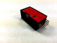
Naze 32 case
...naze 32 case
cults
drone uav
naze 32 case
thingiverse
free

boitier pour naze 32 / case for naze32 by gouweb
...oitier pour naze 32 / case for naze32 by gouweb
thingiverse
boitier de protection pour carte naze 32
protection case for naze 32
thingiverse
free

plaquette pour naze 32 by louff
...plaquette pour naze 32 by louff
thingiverse
plaquette porte naze 32
thingiverse
free

NAZE 32 10DEG CASE by tank21236
...naze 32 10deg case by tank21236
thingiverse
naze 32 10deg case
grabcad
free

Naze 32 Acro - Flight controller
...naze 32 acro - flight controller
grabcad
naze 32 acro - flight controller
thingiverse
free

adapter KK-Naze multicopter controller by gredeby
...adapter kk-naze multicopter controller by gredeby
thingiverse
adapter kk-naze multicopter controller
thingiverse
free
Mini Naze 32 case by idnarbjm
...case, 1 with 30.5mm spacing to fit standard naze or cc3d board holes.
i added a top that says mini naze.
i added a blank top.
3dwarehouse
free

Toyota walton
...toyota walton
3dwarehouse
toyota walton motors building #earabi #shariq #tariq #toyota #walton
3dwarehouse
free

GS Walton Auditorium
...gs walton auditorium
3dwarehouse
#walton
Naze
thingiverse
free

soporte naze by mariors50
...soporte naze by mariors50
thingiverse
soporte naze 32 distancia agujeros 31mm. las tuercas entran con facilidad
thingiverse
free
plaquette pour naze 32 by louff
...plaquette pour naze 32 by louff
thingiverse
plaquette porte naze 32
thingiverse
free
NAZE 32 10DEG CASE by tank21236
...naze 32 10deg case by tank21236
thingiverse
naze 32 10deg case
thingiverse
free
Mini Naze 32 case by idnarbjm
...case, 1 with 30.5mm spacing to fit standard naze or cc3d board holes.
i added a top that says mini naze.
i added a blank top.
thingiverse
free

Naze 32 Rev 6 by andarlo
...naze 32 rev 6 by andarlo
thingiverse
voici un boitier pour carte naze 32 rev 6
thingiverse
free
adapter KK-Naze multicopter controller by gredeby
...adapter kk-naze multicopter controller by gredeby
thingiverse
adapter kk-naze multicopter controller
thingiverse
free
boitier pour naze 32 / case for naze32 by gouweb
...oitier pour naze 32 / case for naze32 by gouweb
thingiverse
boitier de protection pour carte naze 32
protection case for naze 32
thingiverse
free

Strengthened Naze LED Holder by Dubid
...ginal naze led holder from unstabl3 (thing 1275361) was a little weak and broke too many times so this is a strengthened version.
thingiverse
free
Naze 32 case by questpact
...taping.
the concept is to use double sided tape to secure the mount to your frame eliminating vibration to the flight controller.
Walton
turbosquid
$4

Walton Korok
...y free 3d model walton korok for download as ma, fbx, and obj on turbosquid: 3d models for games, architecture, videos. (1623692)
3ddd
$1

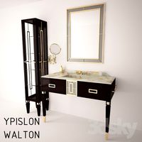
Мебель в санузел YPSILON WALTON
...ypsilon walton
3ddd
ypsilon , walton
мебель в санузел ypsilon walton
мойка 120см и 180см
turbosquid
$20
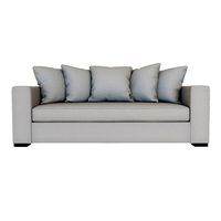
West Elm Walton Sofa
... available on turbo squid, the world's leading provider of digital 3d models for visualization, films, television, and games.
cg_studio
$24

West Elm Walton Sofa3d model
...fabric realistic
.max .obj .fbx - west elm walton sofa 3d model, royalty free license available, instant download after purchase.
turbosquid
$34
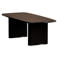
Walton Ribbed Leg Dining Table
... leg dining table for download as max, max, obj, max, and fbx on turbosquid: 3d models for games, architecture, videos. (1614586)
3ddd
$1

West Elm Walton Sofa
...rmats fbx,obj. overall product dimensions: 84"w x 36.5"d x 37"h. (213x92xh93 cm). polygons: 73840 vertices: 73888.
turbosquid
$9

Walton Hall - Antique White Vanity Mirror
... available on turbo squid, the world's leading provider of digital 3d models for visualization, films, television, and games.
3d_export
$20

M41 Walker Bulldog
...bulldog and subsequently, walker bulldog after the late general walton walker, who was killed in a jeep accident in...
3d_sky
$8
The furniture in the bathroom YPSILON WALTON
...e furniture in the bathroom ypsilon walton
3dsky
ypsilon walton
the furniture in the bathroom sink ypsilon walton 120cm and 180cm
Council
3ddd
$1
council
...council
3ddd
council
outside:w29,d26,h25
inside:w22,d19
turbosquid
$15

ROMAN COUNCIL
... available on turbo squid, the world's leading provider of digital 3d models for visualization, films, television, and games.
3ddd
free

Council Lounge Chair by Onecollection
... onecollection
http://www.onecollection.com/products/salto-sigsgaard/council-chair/
turbosquid
$29

The Council of Ministers building
... of ministers building for download as 3ds, max, obj, and fbx on turbosquid: 3d models for games, architecture, videos. (1144655)
3ddd
$1

One Collection Council Chair
...e collection , council
скандинавский дизайн образца 2011 года. уже практически классика.
turbosquid
$29
Council of Ministers Sofia Bulgaria
...nisters sofia bulgaria for download as 3ds, max, obj, and fbx on turbosquid: 3d models for games, architecture, videos. (1306972)
3ddd
$1

Councill LOGAN SIDEBOARD
...ddd
сouncill , комод
http://www.councill.com/product.asp?pid=5046&cid;=108
3d_export
$5

council armchairs
...eloped by pierre guarish for meurop in the 1960s.<br>there are 2 materials in the kit.<br>size - 63*55*73 centimeter.
turbosquid
$39

Councill Living Room Blaise Executive Chair 6901
... available on turbo squid, the world's leading provider of digital 3d models for visualization, films, television, and games.
3d_export
$13

VR Conference Hall - Council - Parliament - Control Room
...high quality (2k or 4k) and categorized.<br>you can send a message for any problem, any other project, question or request.
Studies
3d_export
$10

modern study
...modern study
3dexport
modern study
3d_export
$7

american study
...american study
3dexport
american study
3d_export
$7

modern study
...modern study
3dexport
modern study
3d_export
$10

modern study
...modern study
3dexport
modern study vr4.1
3d_export
$10

modern study
...modern study
3dexport
modern study vr4.1
3d_export
$10

modern study
...modern study
3dexport
modern study vr4.1
3d_export
$10
modern study
...modern study
3dexport
modern study vr4.1
3d_export
$10

modern study
...modern study
3dexport
modern study vr4.1
3d_export
$10

modern study
...modern study
3dexport
modern study vr4.1
turbosquid
$25

Study
... available on turbo squid, the world's leading provider of digital 3d models for visualization, films, television, and games.
Field
design_connected
$27

Field
...field
designconnected
decameron field computer generated 3d model. designed by ferreira, marcus.
turbosquid
$4

field
... available on turbo squid, the world's leading provider of digital 3d models for visualization, films, television, and games.
3d_export
$65
field
...field
3dexport
simple rendering of the scene file
3d_export
$65
field
...field
3dexport
simple rendering of the scene file
3d_export
$65
field
...field
3dexport
simple rendering of the scene file
3d_export
$65

field
...field
3dexport
simple rendering of the scene file
3d_export
$65

field
...field
3dexport
simple rendering of the scene file
3d_export
$65
field
...field
3dexport
simple rendering of the scene file
3d_export
$20

sunflower field
...sunflower field
3dexport
field with sunflowers. helianthus - sunflowers sunflower
3ddd
$1
Foscarini Fields
...lds
3ddd
foscarini , fields
http://www.foscarini.com/en/lamps/wall/fields.html