CG Trader

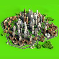
Oakland - city and surroundings
by CG Trader
Last crawled date: 1 year, 9 months ago
This is exact and accurate to scale 3D city model of Oakland, California and its surrounding area based on GIS data (May 2020) File units: Meters Scale: 1:1 NO MISSING BUILDINGS! This is the only product on the market with 100% buildings coverage from 125,192,184 buildings footprint polygon geometries in all 50 U.S. States PACKAGE CONTENTS This collection may include scenes of different size Complete scene (city and surrounding area) 25x25km - Full city extents (incl. airport) 10x10km - Oakland International Airport - OAK Please request any area crop you need FORMATS INCLUDED MAX - Autodesk 3dsMax FBX, OBJ, DAE - Exchange Format UNITYPACKAGE - Unity 3D 3DM - Rhino 3D SKP - SketchUp BLEND - Blender C4D - Cinema4D MA, MB - Autodesk Maya DWG - Autodesk AutoCAD RVT - Autodesk Revit / request PRODUCT INFO KEY BENEFITS Live 24/7 support (format conversion, software adjustment, area cropping, etc.) This 3D city model is georeferenced, exact and accurate to real-world scale Buildings, landuse areas, roads and railways split by type (see scene structure) The surface is flat, easy to add details and edit geometry (terrain on request) Realistic low-poly trees and forests EXTRAS (on request) Administrative boundaries of all levels (named polygons or outlines) Road and railway splines for traffic animation Public transport stops with names PRESENTATION IMAGES Product is ready to render out-of-the-box (3dsmax + corona renderer) 4K high-resolution realistic renderings (refer to images for level of detail) MATERIALS Buildings are UVW mapped, split by material IDs, no textures assigned Trees, vegetation, landuse and airport surface with the textures assigned SCENE STRUCTURE - model is organized by layers, all objects split by type and named properly BUILDINGS residential commercial industrial public sports parkings transport ROADS highways primary secondary tertiary residential service RAILWAYS train city tram subway monorail PAVEMENT sidewalk footway cycleway LANDUSE residential public industrial construction agriculture VEGETATION forest grass scrub park garden cemetery recreation NATURAL land sea lake river AIRPORT building (terminal, gates) apron taxiway runway SUPPORT - please send us a message 24/7 FREE - Product update with the latest GIS data $299+ - Request any other city or area (same day delivery) $199+ - Add terrain based on SRTM or LIDAR elevation data (3-5 LODs optimized) berkeley oakland san francisco california model city urban area bay map downtown building airport scene skyline topography suburb neighborhood sketchup exterior cityscape city building city map city scene city skyline san francisco
Similar models
cg_trader
$299

Omsk - city and surroundings
...t exterior city street city building city landscape city map city scene city skyline city street industrial building street scene
cg_trader
$299

Novosibirsk - city and surroundings
...rior cityscape street exterior city street city building city landscape city map city scene city skyline city street street scene
cg_trader
$299

Wuhan - city and surroundings
...cape street exterior city street china map city building city landscape city map city scene city skyline city street street scene
cg_trader
$299

Tallinn - city and surroundings
...rior cityscape street exterior city street city building city landscape city map city scene city skyline city street street scene
cg_trader
$299

Sochi - city and surroundings
...rior cityscape street exterior city street city building city landscape city map city scene city skyline city street street scene
cg_trader
$299
Pattaya - city and surroundings
...e city model center skyline topography suburb neighborhood sketchup city building city landscape city map city scene city skyline
cg_trader
$299

Tianjin - city and surroundings
...raper skyline park topography sketchup exterior cityscape china map city building city landscape city map city scene city skyline
cg_trader
$299
Chengdu - city and surroundings
...china airport exterior cityscape sketchup rhino street exterior city street city building city skyline city street rhino building
cg_trader
$299

Suzhou - city and surroundings
...ior cityscape street exterior city street china map city building city landscape city map city skyline city street rhino building
cg_trader
$299

Surabaya - city and surroundings
...ighborhood sketchup exterior cityscape street exterior city street city building city landscape city map city skyline city street
Oakland
3d_export
$49
Oakland International Airport 10km
...oakland international airport 10km
3dexport
3d_export
$5

Oakland Iron Street Light pole v3
...ght pole v3
3dexport
this one is good for you can 3d print or create games or animation, making decoration at home is also good.
3d_export
$199

oakland city california usa 50km
...der ready. 1. suitable for games, games, education, architecture etc. 2. mainly used for town and urban planning, real estate etc
thingiverse
free

Oakland Pride by imjohsep
...oakland pride by imjohsep
thingiverse
simple oakland tree magnet model with cavity for inserting earth magnet.
thingiverse
free

Oakland Raiders - Logo by CSD_Salzburg
...oakland raiders - logo by csd_salzburg
thingiverse
oakland raiders - logo
sketchfab
$9

Oakland Cemetery - Powers
...kland cemetery - powers
sketchfab
reality capture 637 images. - oakland cemetery - powers - buy royalty free 3d model by airacon
sketchfab
$18

Oakland Cemetery - Fountain
...in
sketchfab
fountain “out in the rain” - oakland cemetery - fountain - buy royalty free 3d model by airacon
thingiverse
free

Oakland Warriors Logo by BH4BH4
...oakland warriors logo by bh4bh4
thingiverse
my son wanted a golden state warriors "oakland" logo.
thingiverse
free

Oakland Raiders Coaster REMIX by danube97
...oakland raiders coaster remix by danube97
thingiverse
drink coaster with the oakland raiders logo etched in
thingiverse
free
Oakland Raiders Coaster by spondoro
...pondoro
thingiverse
simple coaster with oakland raiders logo etched in. the official logo was too detailed so i made it simpler.
Surroundings
3ddd
$1
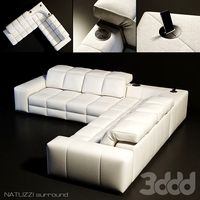
Natuzzi / Surround
...natuzzi / surround
3ddd
natuzzi , угловой
диван natuzzi surround
3d_export
$5
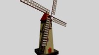
mill with surrounding objects
...mill with surrounding objects
3dexport
a low poly mill with surrounding objects
turbosquid
$20
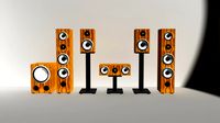
surround system
... available on turbo squid, the world's leading provider of digital 3d models for visualization, films, television, and games.
turbosquid
$20

surround.3DS
... available on turbo squid, the world's leading provider of digital 3d models for visualization, films, television, and games.
3d_ocean
$15
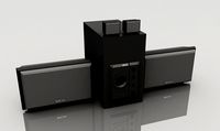
Music Surround System
...obj obj.obj blender.obj xsi.obj //////////////////////////////////////////////////////////////// collection of all diamond rings
3d_export
$50
Fireplace Surround 3D Model
...c fireplace mantel surround modern contemporary textures materials firebox
fireplace surround 3d model 3dfurniture 35358 3dexport
turbosquid
$60

surround speaker set.max
... available on turbo squid, the world's leading provider of digital 3d models for visualization, films, television, and games.
turbosquid
$1

Surround Sound Speakers
... available on turbo squid, the world's leading provider of digital 3d models for visualization, films, television, and games.
3d_export
$20
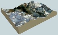
Zermatt and surroundings 3D Model
...t and surroundings 3d model
3dexport
zermatt matterhorn berge alm gebirge
zermatt and surroundings 3d model bu1266 83894 3dexport
turbosquid
$10
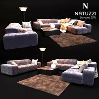
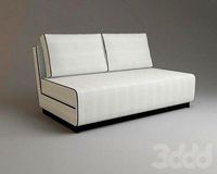
Sofa NATUZZI Surround 2571
... free 3d model sofa natuzzi surround 2571 for download as max on turbosquid: 3d models for games, architecture, videos. (1206944)
City
3d_export
$18
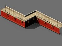
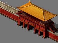
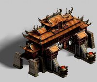
imperial city-city gate-city wall 782
...imperial city-city gate-city wall 782
3dexport
imperial city-city gate-city wall 782<br>3ds max 2015
3d_export
$18
imperial city-city gate-city wall 785
...imperial city-city gate-city wall 785
3dexport
imperial city-city gate-city wall 785<br>3ds max 2015
3d_export
$40
city
...city
3dexport
a city with non-standard architecture.
design_connected
$9
City
...city
designconnected
emmemobili city dining tables computer generated 3d model. designed by ferruccio laviani.
3d_export
$18
imperial city-shabak-city wall
...imperial city-shabak-city wall
3dexport
imperial city-shabak-city wall<br>3ds max 2015
3d_export
$18
imperial city-shabak-city gate
...imperial city-shabak-city gate
3dexport
imperial city-shabak-city gate<br>3ds max 2015
3ddd
$1
Диван City
...диван city
3ddd
city , softline
диван city (фирма softline)
3ddd
$1
Гостиная CITY
...гостиная city
3ddd
city , дятьково
гостиная city производства дятьково
turbosquid
$249

city
...ity
turbosquid
royalty free 3d model city for download as ma on turbosquid: 3d models for games, architecture, videos. (1340610)
turbosquid
$9

City
...ty
turbosquid
royalty free 3d model city for download as obj on turbosquid: 3d models for games, architecture, videos. (1311002)