3DWarehouse
Neighborhood map for Endominium City
by 3DWarehouse
Last crawled date: 1 year ago
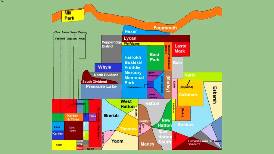
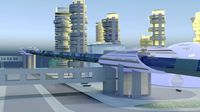
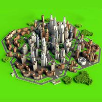
This is the neighborhood map for Endominium City. There are between 57 and 65 neighborhoods (I counted 62, but considering I didn't double- or triple-check it, I was probably off the mark). Most Populous Neighborhood: Pepperridge District Bad side/Ghetto side: Southwest (limited to east of City of the Next-Step Saints and Quinn) Equivalent to Central Park: Farrokh Buslara/Freddie Mercury Memorial Park (Farrokh Buslara was Freddie Mercury's birth name) Neighborhood with the Highest Cost of Living: Mill Park (similar to Beachgate or Middle Park West in Liberty City in Grand Theft Auto IV, EFLC, and Chinatown Wars) Administrative Center (like where City Hall and everything is): Endominium (duh!) The neighborhood identifier that goes off the map is it's own seperate group, so you may delete it if you please. I recommend you hide it instead of delete it, because if you delete it, you won't know the names of seven of the Southwest neighborhoods. (Faramouth is named after the strait it's on, the Strait of Faramouth. The Strait of Faramouth is north of Faramouth.) If you don't know where the Strait of Faramouth is, download my model of Cyberia (the planet), find Endominium City (center-ish of Zazo/the Western Hemisphere), and look directly north.
Similar models
3dwarehouse
free
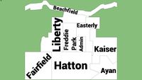
Endominium City Buroughs Map
...n are in more than one burough. if i forgot a neighborhood that's in more than one burough, tell me via reviewing this model.
thingiverse
free

Freddy Mercury anatomically correct Pants
...39;t know who the original statue creator is; as this project is relinked all over thingiverse; but whoever you are -- thank you.
3dwarehouse
free

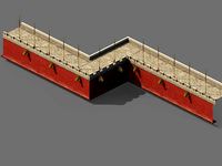
Half Pipe
...t know why, there's a little plaque on the side of it where you can put your name or whatever... #skate_bmx_scooter_half_pipe
3dwarehouse
free

Jurassic Park Visitors Center WIP
...now. but hopefully i'll be able to fix it up. #dinosaur #jurassic #jurassic_park #nitronic #nitronic12 #park #visitors_center
3dwarehouse
free
1997 Endominium Hackale
... 2006, the endominium hackale changed it's name to the endominium emidea. endominium's 1997 version of the ford explorer.
sketchfab
$27
Freddie Mercury 3D printable portrait model
... influencing the artistic direction of queen. - freddie mercury 3d printable portrait model - buy royalty free 3d model by selfix
3dwarehouse
free

Freddy Mercury
...freddy mercury
3dwarehouse
monument of freddy mercury (queen) #freddy #mercury #queen
3dwarehouse
free

Five Post Oak Park Building
...erb character of the immediate neighborhood makes five post oak park one of houston's premier office towers. #houston #uptown
3dwarehouse
free

2012 endominiumcab Gondel
... land than earth has surface area, water and land), zazo is my fictional country. link to the updated zazo map is included below.
cg_trader
$3

Freddie Mercury keychain | 3D
...freddie mercury keychain | 3d
cg trader
freddie mercury keychain. you can modify the dimensions when you go to print.
Endominium
3dwarehouse
free

Endominium Maylo
...
endominium's version of the ford and rouge falcon v6, the maylo. original by rogue. my first endominium. #endominium #maylo
3dwarehouse
free

Endominium Yade
...nium yade
3dwarehouse
endominium's version of the ford expedition. origanal photo-textured model by rouge. #endominium #yade
3dwarehouse
free

Endominium Logo
...endominium logo
3dwarehouse
endominium's new logo!
3dwarehouse
free

Endominium wX
...endominium wx
3dwarehouse
this is a new wheel from endominium. this is also unlocked. #brake_disc_by #dpw
3dwarehouse
free

Endominium W-09
...endominium w-09
3dwarehouse
endominium's 9th wheel. it will be used on the 2011 endominium raptor.
3dwarehouse
free

Endominium One
...ics! the endominium one is endominium's first phone! powered by an endomized version of the android os. verizon logo by kyle.
3dwarehouse
free

Endominium Maverk
...ustang. original by either dmk or blank. #cobra #endominium #ford #known_really_unknown #maverick #maverk #mustang #rouge #trojan
3dwarehouse
free

New Endominium Logo
...new endominium logo
3dwarehouse
new endominium logo
3dwarehouse
free

Endominium One
...endominium one
3dwarehouse
endominium's first computer. windows 7 equiped. it has a webcam by default. it is a tablet.
3dwarehouse
free

2009 Endominium Mai
...2009 endominium mai
3dwarehouse
endominium's version of the ford escape. original by rogue. #endominium #escape #ford #mai
Neighborhood
turbosquid
$1

Neighborhood
... available on turbo squid, the world's leading provider of digital 3d models for visualization, films, television, and games.
turbosquid
$1

Neighborhood
... available on turbo squid, the world's leading provider of digital 3d models for visualization, films, television, and games.
turbosquid
$15

Modular neighborhood
...
royalty free 3d model modular neighborhood for download as on turbosquid: 3d models for games, architecture, videos. (1502930)
turbosquid
$48

Neighborhood Wall
...e 3d model neighborhood wall for download as ma, obj, and fbx on turbosquid: 3d models for games, architecture, videos. (1253455)
turbosquid
$45
Futuristic neighborhood
...uturistic neighborhood for download as max, fbx, 3ds, and dwg on turbosquid: 3d models for games, architecture, videos. (1681656)
turbosquid
$50

neighborhood+ park
... available on turbo squid, the world's leading provider of digital 3d models for visualization, films, television, and games.
3d_export
$25
City Neighborhood 3D Model
...city neighborhood 3d model
3dexport
city neighborhood urban town roads
city neighborhood 3d model rohitmy 54266 3dexport
turbosquid
$49

Neighborhood Houses 03
... available on turbo squid, the world's leading provider of digital 3d models for visualization, films, television, and games.
turbosquid
$25

Neighborhood Music Pub
... available on turbo squid, the world's leading provider of digital 3d models for visualization, films, television, and games.
turbosquid
$19

Neighborhood House P37
...orhood houses p37 for download as 3ds, max, obj, fbx, and dae on turbosquid: 3d models for games, architecture, videos. (1265106)
City
3d_export
$18
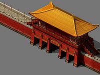
imperial city-city gate-city wall 782
...imperial city-city gate-city wall 782
3dexport
imperial city-city gate-city wall 782<br>3ds max 2015
3d_export
$18
imperial city-city gate-city wall 785
...imperial city-city gate-city wall 785
3dexport
imperial city-city gate-city wall 785<br>3ds max 2015
3d_export
$40
city
...city
3dexport
a city with non-standard architecture.
design_connected
$9

City
...city
designconnected
emmemobili city dining tables computer generated 3d model. designed by ferruccio laviani.
3ddd
$1

Диван City
...диван city
3ddd
city , softline
диван city (фирма softline)
3ddd
$1
Гостиная CITY
...гостиная city
3ddd
city , дятьково
гостиная city производства дятьково
3d_export
$18
imperial city-shabak-city wall
...imperial city-shabak-city wall
3dexport
imperial city-shabak-city wall<br>3ds max 2015
3d_export
$18
imperial city-shabak-city gate
...imperial city-shabak-city gate
3dexport
imperial city-shabak-city gate<br>3ds max 2015
turbosquid
$300

City
...ty
turbosquid
royalty free 3d model city for download as 3ds on turbosquid: 3d models for games, architecture, videos. (1235306)
turbosquid
$249

city
...ity
turbosquid
royalty free 3d model city for download as ma on turbosquid: 3d models for games, architecture, videos. (1340610)
Map
3d_ocean
$5

Map
...map
3docean
geography map ocean travel world world map
a world map
3d_ocean
$5

Old Map
...old map
3docean
dirty map ocean old map paper pirates rotten travel world map
an old map
turbosquid
$3

Map
... available on turbo squid, the world's leading provider of digital 3d models for visualization, films, television, and games.
3d_ocean
$3

Map of Iran
...map of iran
3docean
flag iran map outline
an outline map of iran
3d_ocean
$2

Map of the USA
...map of the usa
3docean
america flag globe map united states usa
an outline map of the usa
3ddd
$1

Abstract Maps
... город , picture
abstract maps by artist jazzberry blue
3d_ocean
$5

Honduras Map
...honduras map
3docean
3d cinema4d honduras map mapa
honduras map designed in cinema 4d r17
3d_ocean
$2

Map of Germany
...map of germany
3docean
black country europe germany gold map outline red yellow
a simple outline map of germany
3d_ocean
$2

Map of Australia
...map of australia
3docean
australia banner country down under earth flag globe map ocean south
an outline map of australia
3d_ocean
$2

Map of Russia
...of russia
3docean
asia banner earth europe flag globe map russia russian federation siberia sovjet union
an outline map of russia