Thingiverse
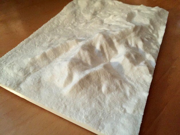
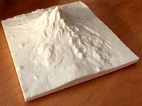
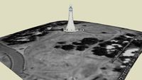
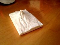
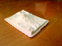
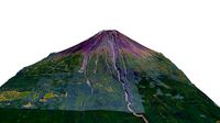
Mount Greylock (Western MA) by tpsully
by Thingiverse
Last crawled date: 2 years, 11 months ago
Mount Greylock (highest point in Massachusetts) - Constructed using 1 arcsecond resolution SRTM data from the Space Shuttle. This is using a new and, as yet, unreleased version of SRTM2STL. The source code for creating files at 3 arcsecond resolution is available up on github under the GNU license. Go to github and search for SRTM2STL. I hope to release the new software as soon as I get any kinks out.
Similar models
thingiverse
free

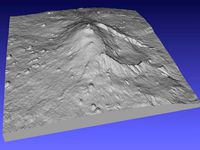
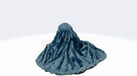
Mount Fuji (1 arcsecond) by tpsully
...r creating files at 3 arcsecond resolution is available up on github under the gnu license. go to github and search for srtm2stl.
thingiverse
free

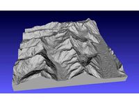
Mount Meru - Tanzania by tpsully
...b under the gnu license. go to github and search for srtm2stl. i hope to release the new software as soon as i get any kinks out.
thingiverse
free
Mount Shasta - California (1 arcsecond) by tpsully
...r creating files at 3 arcsecond resolution is available up on github under the gnu license. go to github and search for srtm2stl.
thingiverse
free

Mount Ontake - Japan by tpsully
...r creating files at 3 arcsecond resolution is available up on github under the gnu license. go to github and search for srtm2stl.
thingiverse
free

Mount Katahdin Region - Maine by tpsully
...r creating files at 3 arcsecond resolution is available up on github under the gnu license. go to github and search for srtm2stl.
thingiverse
free

Mount Hotham by tpsully
...r creating files at 3 arcsecond resolution is available up on github under the gnu license. go to github and search for srtm2stl.
thingiverse
free

Mount Whitney - California by tpsully
...r creating files at 3 arcsecond resolution is available up on github under the gnu license. go to github and search for srtm2stl.
thingiverse
free

Mount Everest by tpsully
...r creating files at 3 arcsecond resolution is available up on github under the gnu license. go to github and search for srtm2stl.
thingiverse
free
Mount Etna - Sicily by tpsully
...r creating files at 3 arcsecond resolution is available up on github under the gnu license. go to github and search for srtm2stl.
thingiverse
free
Mt. Cook New Zealand by tpsully
...r creating files at 3 arcsecond resolution is available up on github under the gnu license. go to github and search for srtm2stl.
Greylock

Tpsully
thingiverse
free

Honolulu Hawaii by tpsully
.... the source code for creating these files is available up on github under the gnu license. go to github and search for srtm2stl.
thingiverse
free

K2 by tpsully
...r creating files at 3 arcsecond resolution is available up on github under the gnu license. go to github and search for srtm2stl.
thingiverse
free
Krakatoa Islands by tpsully
.... the source code for creating these files is available up on github under the gnu license. go to github and search for srtm2stl.
thingiverse
free
Iztaccihuatl by tpsully
...r creating files at 3 arcsecond resolution is available up on github under the gnu license. go to github and search for srtm2stl.
thingiverse
free

Montserrat by tpsully
...r creating files at 3 arcsecond resolution is available up on github under the gnu license. go to github and search for srtm2stl.
thingiverse
free
The Eiger by tpsully
...r creating files at 3 arcsecond resolution is available up on github under the gnu license. go to github and search for srtm2stl.
thingiverse
free

Calbuco by tpsully
...r creating files at 3 arcsecond resolution is available up on github under the gnu license. go to github and search for srtm2stl.
thingiverse
free
Mount Adams - Washington by tpsully
.... the source code for creating these files is available up on github under the gnu license. go to github and search for srtm2stl.
thingiverse
free

Mount Hood - Oregon by tpsully
.... the source code for creating these files is available up on github under the gnu license. go to github and search for srtm2stl.
thingiverse
free
Mount Shasta - California by tpsully
.... the source code for creating these files is available up on github under the gnu license. go to github and search for srtm2stl.
Western
3d_export
$5
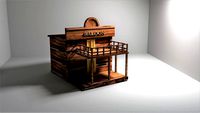
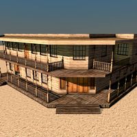
western house
...western house
3dexport
western house
3d_ocean
$15
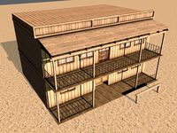
Western Building
...western building
3docean
3d building game house low low poly model poly western
western building -15 objects -11472 polygons
3d_ocean
$20
Western Building C
...western building c
3docean
3d old old model western western building
western building ( format: .c4d & .obj ) – 24 objects
3d_ocean
$19
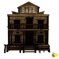
Western Bank
...e optimized western bank building. artistically designed low poly model of bank is an ideal for your aesthetically pleasing game.
3d_ocean
$25
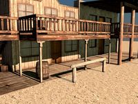
Western Building B
...western building b
3docean
building low poly western
western building (format: .c4d & .obj ) – 29 objects
3ddd
$1
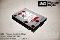
Western Digital
...l-147; h-26.1
western digital red nas hard drive wd30efrx 3tb intellipower 64mb cache sata 6.0gb/s 3.5" internal hard drive
turbosquid
$105

Western watertank
...
royalty free 3d model western watertank for download as max on turbosquid: 3d models for games, architecture, videos. (1378139)
turbosquid
$10

Western Wagon
...id
royalty free 3d model western wagon for download as blend on turbosquid: 3d models for games, architecture, videos. (1674606)
turbosquid
$2

Western Church
...d
royalty free 3d model western church for download as blend on turbosquid: 3d models for games, architecture, videos. (1231071)
3d_ocean
$19
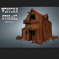
Western Storage
...m/market-item/western-storage/ very detailed western storage. works for many game genres like, fps, third person, top down, st...
Mount
3d_export
free
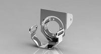
mounting bracket
...mounting plate is the portion of a hinge that attaches to the wood. mounting plates can be used indoors, cabinetry and furniture.
turbosquid
$2
MOUNTING
... available on turbo squid, the world's leading provider of digital 3d models for visualization, films, television, and games.
turbosquid
free
Mounts
... available on turbo squid, the world's leading provider of digital 3d models for visualization, films, television, and games.
turbosquid
free
Mount Fuji
...fuji
turbosquid
free 3d model mount fuji for download as obj on turbosquid: 3d models for games, architecture, videos. (1579977)
3d_export
$5
Headphone mount LR
...headphone mount lr
3dexport
headphone mount l+r
turbosquid
$39
Mount rainier
...quid
royalty free 3d model mount rainier for download as fbx on turbosquid: 3d models for games, architecture, videos. (1492586)
turbosquid
$5

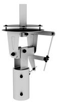
pipe mounting
...quid
royalty free 3d model pipe mounting for download as obj on turbosquid: 3d models for games, architecture, videos. (1293744)
3d_export
$5

Magnetic GoPro Mount
...pro mount
3dexport
cool magnetic mount for gopro. allows you to mount the camera on flat metal surfaces and get exclusive shots.
turbosquid
$5
Stone Mount
...ty free 3d model stone mount for download as ma, obj, and fbx on turbosquid: 3d models for games, architecture, videos. (1370306)
3ddd
$1
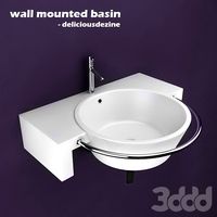
Wall Mounted Basin
...wall mounted basin
3ddd
high detailed wall mounted basin
material included