Thingiverse
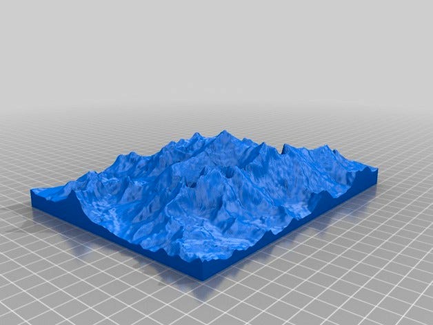
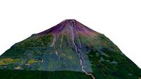
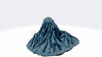
Mount Everest 1:100000 by jawensi
by Thingiverse
Last crawled date: 3 years ago
Modelo topográfico del monte Everest en Nepal. Creado a partir de datos GMRT descargados desde el servicio web:http://www.marine-geo.org/tools/maps_grids.php
Para la obtención del modelo STL, se ha usado DEMto3d, una herramienta útil y fácil de usar para covertir MDE (modelos digitales de elevaciones) en modelos STL, listos para imprimir en 3D. DEMto3D está disponible en la siguiente dirección: http://www.demto3d.com/
DEMto3D funciona como una extensión disponibles para los softwares SIG gratuitos Kosmo (http://www.opengis.es/) y QGIS (http://www.qgis.org/en/site/)
Topography model of the Mount Everest in Nepal. Created from GMRT data downloaded from http://www.marine-geo.org/tools/maps_grids.php
To obtain the STL model, I used DEMto3d, an easy and useful tool to convert DEM data to STL models ready to print. This tool is available in the next link http://www.demto3d.com/
DEMto3D is a plugin available for free GIS software Kosmo (http://www.opengis.es/) and QGIS (http://www.qgis.org/en/site/)
Similar models
thingiverse
free

Matterhorn 1:30000 by jawensi
...d.com/
demto3d is a plugin available for free gis software kosmo (http://www.opengis.es/) and qgis (http://www.qgis.org/en/site/)
thingiverse
free

Yosemite Valley 1:75000 by jawensi
...d.com/
demto3d is a plugin available for free gis software kosmo (http://www.opengis.es/) and qgis (http://www.qgis.org/en/site/)
thingiverse
free

Naranjo de Bulnes 1:5000 by jawensi
...d.com/
demto3d is a plugin available for free gis software kosmo (http://www.opengis.es/) and qgis (http://www.qgis.org/en/site/)
thingiverse
free

Sierra Nevada 1:40000 by jawensi
...d.com/
demto3d is a plugin available for free gis software kosmo (http://www.opengis.es/) and qgis (http://www.qgis.org/en/site/)
thingiverse
free

Teruel Topographic Map by Victoresge
...raphic map of teruel in spain, was made using kosmo software (http://www.opengis.es/) and demto3d extension (http://demto3d.com/)
thingiverse
free

Alcañiz Topographic Map by Victoresge
...e village of alcañiz in spain, was made using kosmo software (http://www.opengis.es/) and demto3d extension (http://demto3d.com/)
thingiverse
free

Mount St. Helens by sitts314
...panoramas_org3.htm
software used:
qgis http://qgis.org/en/site/
heightmap2stl.jar http://www.thingiverse.com/thing:15276/#files
thingiverse
free

Mount Feathertop by lockylast
...nt hotham.
dem data sourced from data.vic.gov.au, and converted to stl using the qgis demto3d plugin. label added with fusion360.
thingiverse
free
Mount Everest by gluetolf
...odel of mount everest built out of data provided by viewfinderpanoramas.org. using qgis, 3dem and accutrans 3d. reduced polygons.
cg_trader
$11

ALIEN FACEHUGGER STL - ABRAZACARAS ALIEN | 3D
...a base en una sola pieza, incluye una base dividida en 4 partes para una impresion más cómoda según las preferencias del maker3d.
Jawensi
thingiverse
free
Matterhorn 1:30000 by jawensi
...d.com/
demto3d is a plugin available for free gis software kosmo (http://www.opengis.es/) and qgis (http://www.qgis.org/en/site/)
thingiverse
free
Yosemite Valley 1:75000 by jawensi
...d.com/
demto3d is a plugin available for free gis software kosmo (http://www.opengis.es/) and qgis (http://www.qgis.org/en/site/)
thingiverse
free
Sierra Nevada 1:40000 by jawensi
...d.com/
demto3d is a plugin available for free gis software kosmo (http://www.opengis.es/) and qgis (http://www.qgis.org/en/site/)
thingiverse
free
Naranjo de Bulnes 1:5000 by jawensi
...d.com/
demto3d is a plugin available for free gis software kosmo (http://www.opengis.es/) and qgis (http://www.qgis.org/en/site/)
thingiverse
free

3DBL1 Landform parts 2 by 3DBear_Official
...lesson plan, based on design of javier vencesla. reference: https://www.thingiverse.com/jawensidesigns ...
thingiverse
free

3DBL1 Landform parts 3 by 3DBear_Official
...lesson plan, based on design of javier vencesla. reference: https://www.thingiverse.com/jawensidesigns ...
thingiverse
free

3DBL1 Landform parts 4 by 3DBear_Official
...lesson plan, based on design of javier vencesla. reference: https://www.thingiverse.com/jawensidesigns ...
thingiverse
free

3DBL1 Landform parts 1 by 3DBear_Official
...lesson plan, based on design of javier vencesla. reference: https://www.thingiverse.com/jawensidesigns ...
Everest
turbosquid
$10

JBL Everest 310
...id
free 3d model jbl everest 310 for download as 3ds and obj on turbosquid: 3d models for games, architecture, videos. (1447843)
turbosquid
$5
ski doo everest
... available on turbo squid, the world's leading provider of digital 3d models for visualization, films, television, and games.
3d_ocean
$89
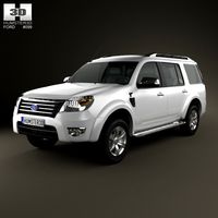
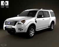
Ford Everest 2012
...y, in real units of measurement, qualitatively and maximally close to the original. model formats: - *.max (3ds max 2008 scanl...
turbosquid
$10

Mount Everest Realistic terrain
...l mount everest realistic terrain for download as fbx and obj on turbosquid: 3d models for games, architecture, videos. (1633014)
cg_studio
$99
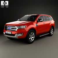
Ford Everest 20123d model
...
.3ds .c4d .fbx .lwo .max .mb .obj - ford everest 2012 3d model, royalty free license available, instant download after purchase.
turbosquid
$29

Mount Everest large landscape
...verest large landscape for download as max, obj, c4d, and fbx on turbosquid: 3d models for games, architecture, videos. (1250928)
turbosquid
$39

Mountain landscape Chomolungma Everest
...olungma everest for download as blend, fbx, obj, 3ds, and dae on turbosquid: 3d models for games, architecture, videos. (1673835)
humster3d
$75

3D model of Ford Everest 2012
...a detailed 3d model of ford everest 2012 in various file formats. all our 3d models were created maximally close to the original.
humster3d
$75
3D model of Ford Everest 2014
...a detailed 3d model of ford everest 2014 in various file formats. all our 3d models were created maximally close to the original.
turbosquid
$19

Mountain landscape Chomolungma Mount Everest
...nt everest for download as max, blend, fbx, 3ds, obj, and dae on turbosquid: 3d models for games, architecture, videos. (1699956)
100000
3ddd
$1

Дверная ручка
...дверная ручка 3ddd дверная ручка 100000 ...
3ddd
$1

Декор Каркас на подставке
...на подставке 3ddd подставка декор "каркас на подставке" полигонов 100000 текстура...
3ddd
free
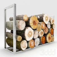
Дрова на подставке
...на подставке 3ddd дрова , пень сложенные дрова полигонов 100000 точек 53000 карта diffuze 4096x4096 карта bump...
3d_export
$7

among us
...us 3dexport among us this file consists polymesh of 100000 polygons some files like zip file , rar file...
3ddd
$1

Развалины дома
..., здание модель "развалины дома" полигонов - треугольников) - 100000 вершин - 50000 текстура 5000x5000 3d max 2014 +...
3ddd
$1

Камни в цилиндрах
..., галька , гравий модель камней в цилиндрах полигонов 100000 текстура цвета 1024x1024 очень красиво смотрятся в...
3ddd
$1

Развалины крепости
...кирпич , форт модель "развалины крепости" полигоны (треугольники - 100000 вершины - 50000 текстура 6000x6000 3d max 2014 +...
3d_ocean
$20
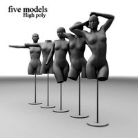
Five different Mannequins dolls base mesh
...models with their bases. each of them has approximate 100000 poly count you can use them for presentation clothes,...
3ddd
$1

Tonin Arc En Ciel Art. 1497 LYRA
...1497 lyra коллекции arc en ciel. размеры 85*130*50 см. 100000 polys. в архиве присутствуют .max 2010, fbx и...
3ddd
$1
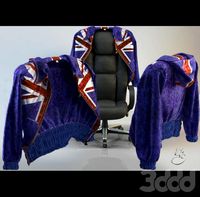
Куртка
...обж 11мб. остальное текстуры. файл материала в наличии. полигонов 100000 точек 70000 к куртке есть брюки. комплект 44 размера...
Mount
3d_export
free

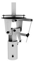
mounting bracket
...mounting plate is the portion of a hinge that attaches to the wood. mounting plates can be used indoors, cabinetry and furniture.
turbosquid
$2
MOUNTING
... available on turbo squid, the world's leading provider of digital 3d models for visualization, films, television, and games.
turbosquid
free
Mounts
... available on turbo squid, the world's leading provider of digital 3d models for visualization, films, television, and games.
turbosquid
free
Mount Fuji
...fuji
turbosquid
free 3d model mount fuji for download as obj on turbosquid: 3d models for games, architecture, videos. (1579977)
3d_export
$5
Headphone mount LR
...headphone mount lr
3dexport
headphone mount l+r
turbosquid
$39
Mount rainier
...quid
royalty free 3d model mount rainier for download as fbx on turbosquid: 3d models for games, architecture, videos. (1492586)
turbosquid
$5

pipe mounting
...quid
royalty free 3d model pipe mounting for download as obj on turbosquid: 3d models for games, architecture, videos. (1293744)
turbosquid
$3
Mounting Tires
...uid
royalty free 3d model mounting tires for download as fbx on turbosquid: 3d models for games, architecture, videos. (1708511)
3d_export
$5

Magnetic GoPro Mount
...pro mount
3dexport
cool magnetic mount for gopro. allows you to mount the camera on flat metal surfaces and get exclusive shots.
turbosquid
$5
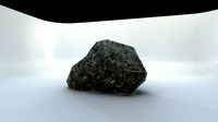
Stone Mount
...ty free 3d model stone mount for download as ma, obj, and fbx on turbosquid: 3d models for games, architecture, videos. (1370306)
1
turbosquid
$69
armchairs(1)(1)
... available on turbo squid, the world's leading provider of digital 3d models for visualization, films, television, and games.
turbosquid
$15
ring 1+1
... available on turbo squid, the world's leading provider of digital 3d models for visualization, films, television, and games.
turbosquid
$10
chair(1)(1)
... available on turbo squid, the world's leading provider of digital 3d models for visualization, films, television, and games.
turbosquid
$8

Chair(1)(1)
... available on turbo squid, the world's leading provider of digital 3d models for visualization, films, television, and games.
turbosquid
$2

RING 1(1)
... available on turbo squid, the world's leading provider of digital 3d models for visualization, films, television, and games.
turbosquid
$1
house 1(1)
... available on turbo squid, the world's leading provider of digital 3d models for visualization, films, television, and games.
turbosquid
$1

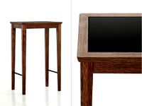
Table 1(1)
... available on turbo squid, the world's leading provider of digital 3d models for visualization, films, television, and games.
turbosquid
$59
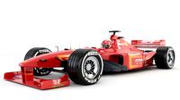
Formula 1(1)
...lty free 3d model formula 1 for download as max, fbx, and obj on turbosquid: 3d models for games, architecture, videos. (1567088)
design_connected
$11
No 1
...no 1
designconnected
sibast no 1 computer generated 3d model. designed by sibast, helge.
turbosquid
$2
desert house(1)(1)
...3d model desert house(1)(1) for download as 3ds, max, and obj on turbosquid: 3d models for games, architecture, videos. (1055095)