Thingiverse
Minnesota Lakes Map by jthorson2
by Thingiverse
Last crawled date: 3 years ago
Notes:
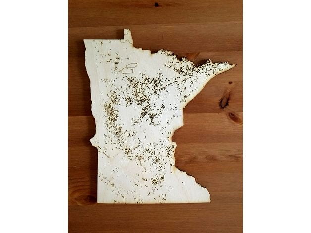
Cut on a 75W Epilog 36EXT from 1/8" Baltic Birch. Etched lakes at 100s/20p/500f and cut at 30s/100p/500f.
Created from the data available at the Minnesota Geospatial Commons.
File is entirely vectors simply because I prefer the look of vector cuts. For my printer at least, you can bump the line width to switch to raster printing if you prefer.
Ovals at the top are there to test out speed/power settings before beginning the cut.
State border is saved as yellow with lakes in red to allow easy selection of one or the other. I plan to cut the outline and etch the details, but you could change either of those.
Similar models
thingiverse
free

Laser Material Test Cut and Etch Template by SomeDork
...ncluded within the file itself. they are outside of the page boundary but are also on their own layer if you prefer to hide them.
thingiverse
free
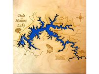
Dale Hollow Lake Map Laser Cut by Sprung
...did not draw the map originally, it is freely found on google, but will be more than happy to credit the creator if anyone knows.
thingiverse
free

Whitefish Lake (MN) Bathymetry Map by drewsloan
..., which, as you can see, is a little underwhelming relative to length, so i'd suggest exaggerating the z-scale in your print.
thingiverse
free
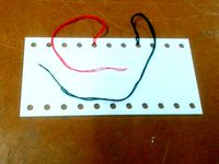
Embroidery Thread Saver by Jenniferaviva
... a glass marker to write the thread numbers on, or i've included the sketchup file if you prefer to etch the numbers into it.
thingiverse
free

Tiny Epic Galaxies Player Mat
... you enjoy them ! please attribute me if you make them, and i would love to see anything that you hoopy froods make.
cheers
andy
3dwarehouse
free

Cessna C182 Floats Takeoff from Minnetonka Lake, Minnesota, USA.
...cessna c182 floats takeoff from minnetonka lake, minnesota, usa.
3dwarehouse
takeoff
thingiverse
free

Shagawa Lake Depth Map by ajlemma
...shagawa lake depth map by ajlemma
thingiverse
scaled depth map of shagawa lake in minnesota. map is from the mn dnr website.
thingiverse
free
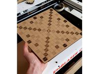
Scrabble Board Laser Cut by BSDCreates
...(blue) fill + line etch (extra dark)
layer 00 (black) line cut
layer 07 (pink) fill + line etch (medium)
layer 08 (grey) line cut
thingiverse
free
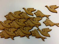
Fish or Fowl? Based on M C Escher's work by Yngel
...ocuse the laser by 5-10 mm and etch the "etch" layer as vectors to get nice, thick lines before refocusing and cutting.
thingiverse
free
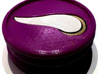
Minnesota Vikings Coaster by spondoro
...oaster by spondoro
thingiverse
simple coaster with minnesota vikings logo etched in. added a second coaster to have just 1 horn.
Minnesota
turbosquid
$49

Minnesota
... available on turbo squid, the world's leading provider of digital 3d models for visualization, films, television, and games.
turbosquid
$15

Minnesota
... available on turbo squid, the world's leading provider of digital 3d models for visualization, films, television, and games.
turbosquid
$56

Minnesota counties
... available on turbo squid, the world's leading provider of digital 3d models for visualization, films, television, and games.
turbosquid
$19

County Map - Minnesota
... available on turbo squid, the world's leading provider of digital 3d models for visualization, films, television, and games.
cg_studio
$35

Minnesota Political Map3d model
...gion province
.obj .3ds .max - minnesota political map 3d model, royalty free license available, instant download after purchase.
3d_export
$15

Flag of minnesota
...rmats<br>3ds max 2017<br>3ds max 2020<br>3ds max 2023<br>obj (multi format)<br>fbx ( multi format )
3d_export
$15

Flag of minnesota 02
...rmats<br>3ds max 2017<br>3ds max 2020<br>3ds max 2023<br>obj (multi format)<br>fbx ( multi format )
3d_export
$39

minnesota flag pack
...r the sake of convenience.<br>for any problems please feel free to contact me.<br>don't forget to rate and enjoy!
3d_export
$199

minneapolis minnesota city usa 40km
...der ready. 1. suitable for games, games, education, architecture etc. 2. mainly used for town and urban planning, real estate etc
3d_export
$199
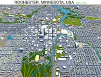
rochester city minnesota usa 50km
...der ready. 1. suitable for games, games, education, architecture etc. 2. mainly used for town and urban planning, real estate etc
Lakes
archibase_planet
free

Lake
...lake
archibase planet
lake landscape scenery
lake n190608 - 3d model (*.gsm+*.3ds) for interior 3d visualization.
3ddd
$1

Lake Dinnerware
... артишоки
набор посуды от crate and barrel
lake bowl
lake mug. 14 oz.
lake salad plate.
lake dinner plate.
camden vase
turbosquid
$2

Lake
...lake
turbosquid
royalty free 3d model lake for download as on turbosquid: 3d models for games, architecture, videos. (1261237)
turbosquid
$5

lake
... available on turbo squid, the world's leading provider of digital 3d models for visualization, films, television, and games.
3d_export
$65

three lakes reflect the west lake
...three lakes reflect the west lake
3dexport
simple rendering of the scene file
3d_export
$65

lake
...lake
3dexport
simple rendering of the scene file
3d_export
$65

The lake
...the lake
3dexport
simple rendering of the scene file
3d_export
$65
The lake
...the lake
3dexport
simple rendering of the scene file
3d_export
$65
lake
...lake
3dexport
simple rendering of the scene file
3d_export
$65

lake
...lake
3dexport
simple rendering of the scene file
Map
3d_ocean
$5

Map
...map
3docean
geography map ocean travel world world map
a world map
3d_ocean
$5

Old Map
...old map
3docean
dirty map ocean old map paper pirates rotten travel world map
an old map
turbosquid
$3

Map
... available on turbo squid, the world's leading provider of digital 3d models for visualization, films, television, and games.
3d_ocean
$3

Map of Iran
...map of iran
3docean
flag iran map outline
an outline map of iran
3d_ocean
$2

Map of the USA
...map of the usa
3docean
america flag globe map united states usa
an outline map of the usa
3ddd
$1

Abstract Maps
... город , picture
abstract maps by artist jazzberry blue
3d_ocean
$5

Honduras Map
...honduras map
3docean
3d cinema4d honduras map mapa
honduras map designed in cinema 4d r17
3d_ocean
$2

Map of Germany
...map of germany
3docean
black country europe germany gold map outline red yellow
a simple outline map of germany
3d_ocean
$2

Map of Australia
...map of australia
3docean
australia banner country down under earth flag globe map ocean south
an outline map of australia
3d_ocean
$2

Map of Russia
...of russia
3docean
asia banner earth europe flag globe map russia russian federation siberia sovjet union
an outline map of russia