Thingiverse
Mars Perseverance Rover Landing Site Jezero Crater: Mars Lesson built with the "NASA Mars Trek" & QGIS by GrowFlavor
by Thingiverse
Last crawled date: 3 years ago
"How Many Oceans & How Many Atmospheres has Mars lost to Rust celebrating the 2021 February 18 Arrival at Mars of Perseverance Rover"
NASA "Where is Perseverance Rover" Map
including various size & scale terrain models of the landing region, class discussion topic ideas, and fun web links with remarkable insights & detail relevant to Mars.
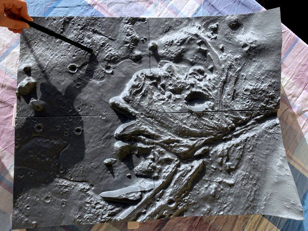
This is also an example of a high detail terrain model making process (more details in the "Print" section below). This work expands upon the easier 'point, click, drag' "Generate 3D Print file" tool which is built into the NASA Mars, Moon, Mercury, Vesta & Ceres Treks. Students may enjoy using the Trek tool to make their own mid-detail 3D printable models of their favorite craters, etc. I describe that built-in web tool in more detail in a separate Moon Trek 'thingi' https://www.thingiverse.com/thing:4732510.
I have included a variety of model sizes & scales from relatively small & easier to print up to a large quad that is more difficult to print.
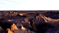
'smallest' model: ~1cm = 1km (1:100k) .STL model with 5x height exaggeration of the Jezero Crater Perseverance Rover Landing Ellipse region.
'larger' model (included in a .ZIP file): ~1cm = 200m (1:20k) .STL model with 5x height exaggeration to show the detail of the dunes in features like Belva crater
'larger' area model (included in a .ZIP file): ~1cm = 2.5km (1:250k) .STL model with 10x height exaggeration showing western Jezero Crater area. Made from a preliminary DEM that still shows stitching in areas.
Quad of adjacent models (included in a .ZIP file) for the landed rover's planned science & exploration region: ~1cm = 200m (1:20k) .STL model with 5x height exaggeration
JEZ_hirise_SE.stl (rover's actual landing area)
JEZ_hirise_SW.stl (Belva crater & potential rover path area)
JEZ_hirise_SE.stl.stl (eroded alluvial fan)
JEZ_hirise_NW.stl (Neretva Vallis entrance) (I had several challenges printing this one.)
Why Send a unique Rover to a very special place on Mars? A few example gains from such an endeavor:
Attempt a significant engineering unknown: Fly an extremely special helicopter (images & description) in air so thin, on another planet, after the 'shake, rattle & roll' of launch, plus about 8 months of space travel !
Help us understand important long-term planet dynamics affecting our ability to grow food & live in cities near flooding shorelines as climate changes on our own planet Earth.
Look for signs of life on Mars from the distant past to further appreciate & understand life on Earth.
Inspire students & governments by demonstrating the "power to accomplish" when skilled people harness their differences, in a collaborative yet challenging process of working together to identify, emphasize, & solve beforehand key factors that can go wrong rather than to downplay serious flaws, in order to innovate new tools & techniques that actually perform well in new & difficult environments.
So, what engineering unknown makes the Mars Helicopter special? Exploring a few similarities & differences between current Mars & Earth will help reveal the difficult & remarkable challenge of flying a Mars Helicopter...
Mars & Earth today are quite different, but both have day times & night times & a Mars 'day' which is called a sol, is only about 40 minutes longer than the current 24 hour Earth 'day' (Earth had much shorter days in the past & will have much longer days in the future as the Moon continues to move farther away...).
Mars today has a dry surface. No rain puddles to trap the Mars Helicopter....but, sand dust in the air, & sand pits & sand dunes (Perseverance's 1st Mars panorama) & cold nights freezing the electronics & batteries will be a challenge. Where on the Mars terrain model(s) do you see or would expect sand dunes? Where on Earth could you find a dry dune surface similar to places on Mars?
Mars in the distant past may have been more similar to Earth today & more parts of Earth could continue to become more like Mars (description). Mars is a bit further from the Sun than Earth, but both Earth & Mars are at 'friendly' distances from the Sun...not too close & not too far. However, Mars has a very different size than Earth & that changes many important things.
Is Mars bigger or smaller than Earth?
Mars is about half the diameter of Earth (NASA Mars facts) & you would weight less than half of what you weigh on Earth. This also makes it easier for some 'air' molecules to escape to space & is partly why Mars likely lost a lot of atmosphere. Less 'air' makes it much more difficult for 'air'planes or helicopters to glide or fly. But, how much less air is there compared with Earth?
To find air this 'thin' on Earth you would need to chase this garlic bread to its highest point where the weather balloon burst (video)! Look at the altitude in the video screenshot: 35.8 km ! This is far above the 10 to 13 km altitude where commercial jet airplanes often fly here on Earth.
What color is the sky above the garlic bread?
What color do you think the sky might mostly be on Mars even in the day?
What color might the Mars sky & sun look if you were standing under all the dust (images & description) the Mars helicopter might kick up? Sometimes Mars gets dust storms so big that the entire planet gets obscured in dust (animated images & description).
What color are sunsets (& often also the clouds) on Mars (images & description)?
Could you glide a plane even at the surface of Mars in such thin air?
Not any normal Earth plane...not even the very high flying Lockheed Martin U2 spy plane would glide (video) because the current air pressure near the surface of Mars is only around 6 millibars...that's very thin compared with Earth's current surface pressure that is around 1000 millibars (1 bar)...Students as well as NASA Ames/NRL projects AME & MAGE as well as the team that designed, tested & built the current Mars helicopter (video) did a fair bit of work to identify some of the real unknowns with 'flying' on Mars.
To use this thin air to move around the small Mars Helicopter uses very large rotor blades that spin extremely fast. Maybe the rover will take a video of the test flight(s) so we can see if those fast blades kick up a lot of dust & sand. If this helicopter works in the very thin air on Mars, then this will become a new way to explore Mars with 'drones'. (& maybe someone also wants to use such a mini helicopter here on Earth, perhaps launched from a 'Rockoon', to chase something like that garlic bread, or a science lab project, in the thin air at the edge of space).
Could you hear sounds on Mars?
Even though the Mars air is currently very thin, sound can still travel through it. If you wanted to go for a walk on Mars today, you would need a pressure suit (space suit) to prevent your body water from boiling. On Earth, that is called being above the Armstrong line (images & description) So while your ears would not directly hear sounds; you could have microphones on your suit to detect the real Mars sounds around you & play them on speakers inside your helmet. NASA JPL is posting sounds recorded by Perseverance Rover's microphones at soundcloud.
Could you survive breathing the atmosphere on Mars compressed into your space suit?
Not today without a tool like MOXIE, but maybe around 3.7 billion years ago. Mars has 'lost' a lot of parts of its atmosphere since that time...some escaped to space, some bonded with surface rocks, some froze as ices ( for those with terraforming interests: atmospheres can collapse & be remade...for example, see Io's current frequent naturally collapsing atmosphere ).
Today, the little amount of Mars' atmosphere 'air' that is left is mostly in the form of carbon dioxide (NASA Mars www page).
While the thin air on Mars today makes it very hard for even a small 'drone' helicopter to fly and liquid water & Earth type life like you to stay at the surface of Mars today, NASA JPL chose to send Perseverance Rover to Jezero Crater, because Mars in the distant past likely once had a much thicker atmosphere with rain storms. Mars probably had:
even more 'air' than Earth's atmosphere today, possibly at times with between 1 to 4 bar surface pressure!
plenty of surface water &
'slow falling' rain with the lower gravitational acceleration & denser atmosphere of past Mars than present day Earth.
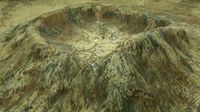
Compare the model with the NASA 'artists' drawing of the probable ancient lake in Jezero crater...
Match the river in the NASA drawing to similar looking features on the model(s). What features might have been under water in the past? Where might there have been ancient shore lines?
What signs of that ancient water can you see in this model? For example, large alluvial fan (maybe students have seen such a pattern in a nearby creek, pond, or rain puddle), Neretva Vallis water cut through the crater's rim,...
Which meteor craters likely formed from impacts that occurred after this Mars lake became dry...for example, craters that show well defined rims with minimal erosion?
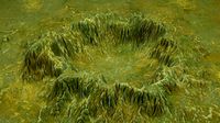
Identify on your model(s) the regions shown in different colors in the USGS coloring activity or USGS geologic map. What differences in texture, flat/steepness/slope, height/elevation, & number of meteor craters do you observe on the models between the different colored regions shown in the geologic map?
The USGS colors represent different types of rock formations...some formed by erupting volcanoes, some by sands blown by the wind, and others made by 'dirt' sediments carried by flowing water.
However, Mars's actual surface color is generally 'rusty'. This color might be because Mars may have lost about one Earth ocean's amount of water (specifically the hydrogen(H) part of water high in the upper atmosphere) to space...possibly leaving the oxygen part of water behind to leave both the Mars ancient ocean & atmosphere to become rock 'rust' on the surface rocks. Rocks with iron will rust with oxygen to make the 'rusty' colored dusts that help make Mars appear to have a reddish/orangish/pinkish colors from a distance..
Now the remaining 'water' is in a few, sometimes very pretty, clouds as shown in these images, but appears to be mostly in salt brines (pdf) or frozen as ices in polar caps & under the dust 'soil':
An amazing high resolution mosaic of images taken by Curiosity rover with Mars clouds, as well as dust & desert rocks
NASA Phoenix Mars Lander Confirms Frozen Water (images & description)
Steep Slopes on Mars Reveal Structure of Buried Ice (images & description)
"Seasonal Streaks Point to Recent Flowing Water on Mars" (images & description)
& some still in under-'dirt' glacier like forms (closeup visual example)
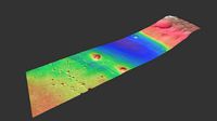
marked as green dots shown in this wide area via the NASA Mars Trek.
With the 'smaller' model = 1:100,000 = 1cm:1km:
Use a string and small ruler to measure & record an estimate of the diameter of Belva crater
locate the center of the landing target ellipse on the model, then measure & record an estimate of its diameter
Why is the target landing area such a 'big' ellipse? Compare the approximate diameter of the ellipse that you just measured and compare it to the 470 million kilometers Perseverance has traveled to get to that landing site...that is even farther than the distance light travels from the Sun to Earth. "By time of landing, Perseverance will have covered 292.5 million miles (470.8 million kilometers), and Mars will be about 130 million miles (209 million kilometers) away from Earth; at that point, a transmission will take about 11.5 minutes to reach the spacecraft." Remarkable since the flight was a direct shot from Earth with no stops along the way.
If you also printed one of the 1:20k models such as the 'larger' model or the "quad", find its area & features in the 'smaller' 1:100k model or 'larger area' 1:250k model & compare the difference in detail. Also, compare details within 1cm = 200m (1:20K) model itself such as the locations & orientations of the sand dunes in various features.
Choose a 'favorite feature of interest' on the model & discuss why.
For example, my 3rd grade child suggested the peaks near the center of the landing ellipse as 'ancient islands in the crater when it was a lake' & we discussed the impact of a change in water depth over time.
There is also the option to follow the rover: mark its path on the model(s) over the next few years & put colored dots at places of key discoveries (and possibly print a matching handout with details of the discovery index keyed with the same color dot) as the science team explores.
NASA "Where is Perseverance Rover" Map
including various size & scale terrain models of the landing region, class discussion topic ideas, and fun web links with remarkable insights & detail relevant to Mars.
This is also an example of a high detail terrain model making process (more details in the "Print" section below). This work expands upon the easier 'point, click, drag' "Generate 3D Print file" tool which is built into the NASA Mars, Moon, Mercury, Vesta & Ceres Treks. Students may enjoy using the Trek tool to make their own mid-detail 3D printable models of their favorite craters, etc. I describe that built-in web tool in more detail in a separate Moon Trek 'thingi' https://www.thingiverse.com/thing:4732510.
I have included a variety of model sizes & scales from relatively small & easier to print up to a large quad that is more difficult to print.
'smallest' model: ~1cm = 1km (1:100k) .STL model with 5x height exaggeration of the Jezero Crater Perseverance Rover Landing Ellipse region.
'larger' model (included in a .ZIP file): ~1cm = 200m (1:20k) .STL model with 5x height exaggeration to show the detail of the dunes in features like Belva crater
'larger' area model (included in a .ZIP file): ~1cm = 2.5km (1:250k) .STL model with 10x height exaggeration showing western Jezero Crater area. Made from a preliminary DEM that still shows stitching in areas.
Quad of adjacent models (included in a .ZIP file) for the landed rover's planned science & exploration region: ~1cm = 200m (1:20k) .STL model with 5x height exaggeration
JEZ_hirise_SE.stl (rover's actual landing area)
JEZ_hirise_SW.stl (Belva crater & potential rover path area)
JEZ_hirise_SE.stl.stl (eroded alluvial fan)
JEZ_hirise_NW.stl (Neretva Vallis entrance) (I had several challenges printing this one.)
Why Send a unique Rover to a very special place on Mars? A few example gains from such an endeavor:
Attempt a significant engineering unknown: Fly an extremely special helicopter (images & description) in air so thin, on another planet, after the 'shake, rattle & roll' of launch, plus about 8 months of space travel !
Help us understand important long-term planet dynamics affecting our ability to grow food & live in cities near flooding shorelines as climate changes on our own planet Earth.
Look for signs of life on Mars from the distant past to further appreciate & understand life on Earth.
Inspire students & governments by demonstrating the "power to accomplish" when skilled people harness their differences, in a collaborative yet challenging process of working together to identify, emphasize, & solve beforehand key factors that can go wrong rather than to downplay serious flaws, in order to innovate new tools & techniques that actually perform well in new & difficult environments.
So, what engineering unknown makes the Mars Helicopter special? Exploring a few similarities & differences between current Mars & Earth will help reveal the difficult & remarkable challenge of flying a Mars Helicopter...
Mars & Earth today are quite different, but both have day times & night times & a Mars 'day' which is called a sol, is only about 40 minutes longer than the current 24 hour Earth 'day' (Earth had much shorter days in the past & will have much longer days in the future as the Moon continues to move farther away...).
Mars today has a dry surface. No rain puddles to trap the Mars Helicopter....but, sand dust in the air, & sand pits & sand dunes (Perseverance's 1st Mars panorama) & cold nights freezing the electronics & batteries will be a challenge. Where on the Mars terrain model(s) do you see or would expect sand dunes? Where on Earth could you find a dry dune surface similar to places on Mars?
Mars in the distant past may have been more similar to Earth today & more parts of Earth could continue to become more like Mars (description). Mars is a bit further from the Sun than Earth, but both Earth & Mars are at 'friendly' distances from the Sun...not too close & not too far. However, Mars has a very different size than Earth & that changes many important things.
Is Mars bigger or smaller than Earth?
Mars is about half the diameter of Earth (NASA Mars facts) & you would weight less than half of what you weigh on Earth. This also makes it easier for some 'air' molecules to escape to space & is partly why Mars likely lost a lot of atmosphere. Less 'air' makes it much more difficult for 'air'planes or helicopters to glide or fly. But, how much less air is there compared with Earth?
To find air this 'thin' on Earth you would need to chase this garlic bread to its highest point where the weather balloon burst (video)! Look at the altitude in the video screenshot: 35.8 km ! This is far above the 10 to 13 km altitude where commercial jet airplanes often fly here on Earth.
What color is the sky above the garlic bread?
What color do you think the sky might mostly be on Mars even in the day?
What color might the Mars sky & sun look if you were standing under all the dust (images & description) the Mars helicopter might kick up? Sometimes Mars gets dust storms so big that the entire planet gets obscured in dust (animated images & description).
What color are sunsets (& often also the clouds) on Mars (images & description)?
Could you glide a plane even at the surface of Mars in such thin air?
Not any normal Earth plane...not even the very high flying Lockheed Martin U2 spy plane would glide (video) because the current air pressure near the surface of Mars is only around 6 millibars...that's very thin compared with Earth's current surface pressure that is around 1000 millibars (1 bar)...Students as well as NASA Ames/NRL projects AME & MAGE as well as the team that designed, tested & built the current Mars helicopter (video) did a fair bit of work to identify some of the real unknowns with 'flying' on Mars.
To use this thin air to move around the small Mars Helicopter uses very large rotor blades that spin extremely fast. Maybe the rover will take a video of the test flight(s) so we can see if those fast blades kick up a lot of dust & sand. If this helicopter works in the very thin air on Mars, then this will become a new way to explore Mars with 'drones'. (& maybe someone also wants to use such a mini helicopter here on Earth, perhaps launched from a 'Rockoon', to chase something like that garlic bread, or a science lab project, in the thin air at the edge of space).
Could you hear sounds on Mars?
Even though the Mars air is currently very thin, sound can still travel through it. If you wanted to go for a walk on Mars today, you would need a pressure suit (space suit) to prevent your body water from boiling. On Earth, that is called being above the Armstrong line (images & description) So while your ears would not directly hear sounds; you could have microphones on your suit to detect the real Mars sounds around you & play them on speakers inside your helmet. NASA JPL is posting sounds recorded by Perseverance Rover's microphones at soundcloud.
Could you survive breathing the atmosphere on Mars compressed into your space suit?
Not today without a tool like MOXIE, but maybe around 3.7 billion years ago. Mars has 'lost' a lot of parts of its atmosphere since that time...some escaped to space, some bonded with surface rocks, some froze as ices ( for those with terraforming interests: atmospheres can collapse & be remade...for example, see Io's current frequent naturally collapsing atmosphere ).
Today, the little amount of Mars' atmosphere 'air' that is left is mostly in the form of carbon dioxide (NASA Mars www page).
While the thin air on Mars today makes it very hard for even a small 'drone' helicopter to fly and liquid water & Earth type life like you to stay at the surface of Mars today, NASA JPL chose to send Perseverance Rover to Jezero Crater, because Mars in the distant past likely once had a much thicker atmosphere with rain storms. Mars probably had:
even more 'air' than Earth's atmosphere today, possibly at times with between 1 to 4 bar surface pressure!
plenty of surface water &
'slow falling' rain with the lower gravitational acceleration & denser atmosphere of past Mars than present day Earth.
Compare the model with the NASA 'artists' drawing of the probable ancient lake in Jezero crater...
Match the river in the NASA drawing to similar looking features on the model(s). What features might have been under water in the past? Where might there have been ancient shore lines?
What signs of that ancient water can you see in this model? For example, large alluvial fan (maybe students have seen such a pattern in a nearby creek, pond, or rain puddle), Neretva Vallis water cut through the crater's rim,...
Which meteor craters likely formed from impacts that occurred after this Mars lake became dry...for example, craters that show well defined rims with minimal erosion?
Identify on your model(s) the regions shown in different colors in the USGS coloring activity or USGS geologic map. What differences in texture, flat/steepness/slope, height/elevation, & number of meteor craters do you observe on the models between the different colored regions shown in the geologic map?
The USGS colors represent different types of rock formations...some formed by erupting volcanoes, some by sands blown by the wind, and others made by 'dirt' sediments carried by flowing water.
However, Mars's actual surface color is generally 'rusty'. This color might be because Mars may have lost about one Earth ocean's amount of water (specifically the hydrogen(H) part of water high in the upper atmosphere) to space...possibly leaving the oxygen part of water behind to leave both the Mars ancient ocean & atmosphere to become rock 'rust' on the surface rocks. Rocks with iron will rust with oxygen to make the 'rusty' colored dusts that help make Mars appear to have a reddish/orangish/pinkish colors from a distance..
Now the remaining 'water' is in a few, sometimes very pretty, clouds as shown in these images, but appears to be mostly in salt brines (pdf) or frozen as ices in polar caps & under the dust 'soil':
An amazing high resolution mosaic of images taken by Curiosity rover with Mars clouds, as well as dust & desert rocks
NASA Phoenix Mars Lander Confirms Frozen Water (images & description)
Steep Slopes on Mars Reveal Structure of Buried Ice (images & description)
"Seasonal Streaks Point to Recent Flowing Water on Mars" (images & description)
& some still in under-'dirt' glacier like forms (closeup visual example)
marked as green dots shown in this wide area via the NASA Mars Trek.
With the 'smaller' model = 1:100,000 = 1cm:1km:
Use a string and small ruler to measure & record an estimate of the diameter of Belva crater
locate the center of the landing target ellipse on the model, then measure & record an estimate of its diameter
Why is the target landing area such a 'big' ellipse? Compare the approximate diameter of the ellipse that you just measured and compare it to the 470 million kilometers Perseverance has traveled to get to that landing site...that is even farther than the distance light travels from the Sun to Earth. "By time of landing, Perseverance will have covered 292.5 million miles (470.8 million kilometers), and Mars will be about 130 million miles (209 million kilometers) away from Earth; at that point, a transmission will take about 11.5 minutes to reach the spacecraft." Remarkable since the flight was a direct shot from Earth with no stops along the way.
If you also printed one of the 1:20k models such as the 'larger' model or the "quad", find its area & features in the 'smaller' 1:100k model or 'larger area' 1:250k model & compare the difference in detail. Also, compare details within 1cm = 200m (1:20K) model itself such as the locations & orientations of the sand dunes in various features.
Choose a 'favorite feature of interest' on the model & discuss why.
For example, my 3rd grade child suggested the peaks near the center of the landing ellipse as 'ancient islands in the crater when it was a lake' & we discussed the impact of a change in water depth over time.
There is also the option to follow the rover: mark its path on the model(s) over the next few years & put colored dots at places of key discoveries (and possibly print a matching handout with details of the discovery index keyed with the same color dot) as the science team explores.
Similar models
cg_trader
$99

Perseverance Mars Rover
...s rover
cg trader
high quality and very detailed 3d model of nasa perseverance rover.
scene includes martian surface and crater.
cg_trader
$69

Ingenuity Mars Helicopter
...s exploration space atmosphere aircraft science rotorcraft technology curiosity curiosity rover mars rover nasa rover space rover
grabcad
free

Perseverance Rover Vehicle of NASA for Mars Missions which landed on February 2021
...mproved?)
https://youtu.be/ueo77uefgt4
how i built a mars perseverance rover replica
https://www.youtube.com/watch?v=nozzmsmagh0
3dwarehouse
free

NASA - Mars Perseverance Rover
...asa's repository of 3d models. materials are named properly and enscape ready. enjoy! #nasa #mars #rover #perseverance #space
thingiverse
free

NASA Perseverance Rover Coaster by AndysTechGarage
...ster for the drinks...
this size fits smaller size glasses but you can enlarge it slightly for your beer mug or coffee cup.
enjoy
grabcad
free

Perseverance Rover Vehicle of NASA
...cad
nasa’s perseverance mars rover vs curiosity
what's new? what's improved?
https://www.youtube.com/watch?v=th2tkigopbu
cg_trader
$40

MARS VR - Candidate Landing Site in Jezero Crater
...xperiment
https://www.uahirise.org/esp_045994_1985 mars martian planet space vr terrain jezero crater mars terrain mars landscape
cg_trader
$15
Mars Surface
...ter grayscale planetoid craters planet outerspace space mars landscape mars planet mars rover mars surface nasa rover space rover
thingiverse
free

Perseverance Rover Mission Patch by PuetzPrints
...severance rover mission patch by puetzprints
thingiverse
celebrating the mars 2020 rover perseverance's successful landing!
cg_trader
$99

Perseverance Mars Rover
...ology perseverance mercury apollo spacecraft lunar launch robot moonwalk cosmonaut spaceship vehicle sci fi sci fi sci fi vehicle
Growflavor
thingiverse
free

Lunar Crater Chain Mendeleev: NASA Moon Trek Chang'e 2 DEM 20m by GrowFlavor
...
nasa mars trek: jezero crater perseverance rover landing area terrain model: https://www.thingiverse.com/thing:4747950
enjoy!
thingiverse
free

Perseverance Rover Landing Site by Pjotrke
...i made the stl myself i want to give growflavor credits for pointing me in the right direction on...
Jezero
thingiverse
free
Lunar Crater Chain Mendeleev: NASA Moon Trek Chang'e 2 DEM 20m by GrowFlavor
...tutorial: hesiodus crater terrain model: https://www.thingiverse.com/thing:4732510 nasa mars trek: jezero crater perseverance rover landing area terrain model: https://www.thingiverse.com/thing:4747950...
cg_trader
$40
MARS VR - Candidate Landing Site in Jezero Crater
...xperiment
https://www.uahirise.org/esp_045994_1985 mars martian planet space vr terrain jezero crater mars terrain mars landscape
cg_trader
$40

MARS VR - Landing Site near Jezero Crater
...ging science experiment
https://www.uahirise.org/esp_022680_1985 mars vr terrain martian mars terrain mars landscape space planet
cg_trader
$40

MARS VR - Delta Structure in Eberswalde Crater
...fan with a distributary network can be found in jezero crater, which may represent a more degraded version of...
cg_trader
$59

Perseverance Mars Rover
...launch on 17 july 2020, and touch down in jezero crater on mars on 18 february 2021. it will...
cg_trader
$99
Perseverance Mars Rover
...a car-sized mars rover designed to explore the crater jezero on mars as part of nasa's mars 2020 mission....
3dwarehouse
free

jezero
...jezero
3dwarehouse
jezero
3dwarehouse
free
Jezero Vlačine
...jezero vlačine
3dwarehouse
3dwarehouse
free
Jezero Sabljaci
...jezero sabljaci
3dwarehouse
Qgis
thingiverse
free

QGis rod for ZED-F9P by Eisinator
...qgis rod for zed-f9p by eisinator
thingiverse
my design for an qgis rod.
thingiverse
free
Mount Everest by gluetolf
...everest built out of data provided by viewfinderpanoramas.org. using qgis 3dem and accutrans 3d. reduced...
thingiverse
free

Mount St. Helens by sitts314
...thingiverse made with data from: http://www.viewfinderpanoramas.org/coverage%20map%20viewfinderpanoramas_org3.htm software used: qgis http://qgisorg/en/site/ heightmap2stl.jar...
thingiverse
free

Mount Feathertop by lockylast
...sourced from data.vic.gov.au, and converted to stl using the qgis demto3d plugin. label added with...
thingiverse
free

Yangpyung Map Puzzle (Korean lable)
...puzzle data source: administrative boundary file from www.juso.go.kr tools: qgis for visual inspection adobe illustrator for svg exporting www.tinkercad.com...
thingiverse
free

Teton Mountains by da429boss
...teton national park(imagery from the usgs 3dep program). used qgis demto3d tool to create the 3d model and sliced...
thingiverse
free

Pinnacle Mountain, Arkansas by stewardj
...is from elevation orthodata from the ned database. used qgis meshlab, and meshmixer to pull it...
thingiverse
free
Calatayud (Spain) - Jalon River Valley by talud08
...by talud08 thingiverse the stl file was created with qgis software from a mdt file, downloaded from the ign...
thingiverse
free

Ben Nevis 3D Terrain Model by gluetolf
...10″ w. created using opendata from https://www.ordnancesurvey.co.uk/opendatadownload/products.html and software: qgis and accutrans...
thingiverse
free

Gifford Marine Park by lockylast
...ausseabed marine portal, and converted to stl using the qgis demto3d plugin. label added with...
Perseverance
3d_export
$28
spacecraft mars perseverance
...helicopter is equipped with a camera system, which can take pictures of mars surface structure with important research value [5].
3d_export
$20

stylish black metal x chair
... the perfect convenient seating solution and have a padded seat and back cushion for added comfort. great finish, amazing design.
thingiverse
free

Perseverance Mars by ThunderClan
...perseverance mars by thunderclan
thingiverse
this is the perseverance rover that is on its way to mars.
thingiverse
free
Perseverance Rover Mission Patch by PuetzPrints
...severance rover mission patch by puetzprints
thingiverse
celebrating the mars 2020 rover perseverance's successful landing!
thingiverse
free
NASA Perseverance Aeroshell by WRRL
...tech jpl perseverance rover, based on sketches.
not an official oml release. geometry is scaled by the aeroshell's diameter.
thingiverse
free

nasa mars perseverance by dvoelkel
...nasa mars perseverance by dvoelkel
thingiverse
m600-filamentchanges at ~ 4.40mm, 5.40mm, 6.40mm
thingiverse
free

Perseverance Mars Rover Keychain by youssefgamal
...ns, to explore the universe around us and expand our horizons.
after all, it's curiosity and perseverance that sent us there.
thingiverse
free

Perseverance sample tubes by tw2002
... the originals but it has no real funktion other than being hollow. i designed it to be made out of metal but it is 3d printable.
thingiverse
free

M2020 Model Rover Perseverance by bilimokulu
...mars in february, 2021 this rover will seek signs of ancient life and collect rock and soil samples for possible return to earth.
thingiverse
free

Perseverance Base Modified by CC3DPRINTING
...erance base modified by cc3dprinting
thingiverse
i modified the base slightly so less chance of failure due to the thin support.
Crater
3d_export
$10
crater
...crater
3dexport
crater<br>textures: col, ao, angle, height, normal map. circular road around the crater.
turbosquid
$39

Crater
... available on turbo squid, the world's leading provider of digital 3d models for visualization, films, television, and games.
3d_ocean
$6
Crater
...eshes max. fbx. obj. formats for other applications. model has 3494406 polygons. also you can watch animation with this model:...
turbosquid
$39
Crater 6
...3d model crater 6 for download as max, obj, c4d, fbx, and stl on turbosquid: 3d models for games, architecture, videos. (1410403)
turbosquid
$39

Crater 4
...3d model crater 4 for download as max, obj, c4d, fbx, and stl on turbosquid: 3d models for games, architecture, videos. (1410204)
turbosquid
$39
Crater 3
...3d model crater 3 for download as max, obj, c4d, fbx, and stl on turbosquid: 3d models for games, architecture, videos. (1410165)
turbosquid
$39

Crater 1
...3d model crater 1 for download as max, obj, c4d, fbx, and stl on turbosquid: 3d models for games, architecture, videos. (1410111)
turbosquid
$29

Kodyor Massive Crater
...model kodyor massive crater for download as max, fbx, and obj on turbosquid: 3d models for games, architecture, videos. (1608520)
turbosquid
$34

CRATER END TABLE
...model crater end table for download as max, max, fbx, and obj on turbosquid: 3d models for games, architecture, videos. (1563272)
turbosquid
$40

Space City in a Crater
... available on turbo squid, the world's leading provider of digital 3d models for visualization, films, television, and games.
Lesson
evermotion
$60

SKETCHUP Video Tutorial part 1
...modeling video tutorial modelling part sketchup modelling tutorial includes: lesson 1 - introduction (software interface, plugins, etc.) lesson 2...
3ddd
$1

Фэнтезийный двуручный меч
...моделировался в процессе написания урока "фентезийный меч" для сайта 3dmax.ruhttp://www.3dmax.ru/modeling/lesson/270.html http://www.3dmax.ru/modeling/lessons/271.html http://www.3dmax.ru/modeling/lessons/272.html http://www.3dmax.ru/modeling/lessons/273.html http://www.3dmax.ru/modeling/lessons/274.html ...
evermotion
$60

SKETCHUP Video Tutorial part 2
...and rendering (with vray for sketchup 1.48.89) tutorial includes: lesson 1 - illumination setting lesson 2 - kitchen zone...
3d_export
free

Beach home
...beach home 3dexport simple home on the beach from lesson on...
3d_export
$30

Sexy Anime Girl in Underwear
...would like to have a private 1 on 1 lesson with miss xiao…then go check out the link...
3d_ocean
$15
Highpoly 3d Model of Electrostatic Machine
...current device discharge education electricity electrostatic experiments highpoly laboratory lesson machine mechanism mesh model physics polygons school science scientific...
3d_export
$79

titanfall pilot
...final portion is set up as more of a lesson than a requirement, since typically one ***an faced against...
3d_export
$7
wire and wire copper axis fpc adhesive tape laser cutting peeling cutting machine - final assembly
...and learn the drawings. it's very good to draw lesson from the contents of the drawings. after downloading, you...
thingiverse
free

Landmark Skyline Lesson by ckondreck
...landmark skyline lesson by ckondreck
thingiverse
landmark skyline lesson
thingiverse
free

Camel Habitat Lesson by Carlos122684
...camel habitat lesson by carlos122684
thingiverse
this 3d model can be used as a lesson on the desert biome
Trek
turbosquid
$47

Trekking bike
... available on turbo squid, the world's leading provider of digital 3d models for visualization, films, television, and games.
3ddd
free

Ceccotti Star Trek
...
описание: кресло "star trek"
сайт: www.ceccotticollezioni.it
все subdivision.
внутри архива текстура, 3ds и max файлы.
3ddd
$1

Star Trek - Ceccotti Collezioni
...r_trek/
количество полигонов - 29 000, но стек открыт, так что turbosmooth по желанию
v-ray, corona
max 2011,2014
turbosquid
$25

Star trek The Mandalorian Knife
...e cosplay prop replica for download as max, dwg, fbx, and obj on turbosquid: 3d models for games, architecture, videos. (1607086)
3d_export
$99

Fiat 500l Trekking 2014 3D Model
...ssover allterrain offroad italian 500 italy fiat 2017 500l trekking treking
fiat 500l trekking 2014 3d model squir 71255 3dexport
cg_studio
$99

Fiat 500L Trekking 20143d model
...3ds .c4d .fbx .lwo .max .obj - fiat 500l trekking 2014 3d model, royalty free license available, instant download after purchase.
turbosquid
$25

Star Trek Planter Replica prop
...k planter replica prop for download as max, dwg, fbx, and obj on turbosquid: 3d models for games, architecture, videos. (1598563)
turbosquid
$18
Star Trek Voyager Neural Stimulator
...neural stimulator for download as max, dwg, fbx, obj, and stl on turbosquid: 3d models for games, architecture, videos. (1590142)
turbosquid
$10
Star Trek Exoscalpel Prop Replica
...lpel prop replica for download as max, dwg, fbx, obj, and stl on turbosquid: 3d models for games, architecture, videos. (1596923)
humster3d
$75

3D model of Fiat 500L Trekking 2013
...iled 3d model of fiat 500l trekking 2013 in various file formats. all our 3d models were created maximally close to the original.
Nasa
turbosquid
$49
Nasa Marscopter
...id
royalty free 3d model nasa marscopter for download as max on turbosquid: 3d models for games, architecture, videos. (1323349)
turbosquid
$500
NASA Crawler
... available on turbo squid, the world's leading provider of digital 3d models for visualization, films, television, and games.
turbosquid
$5
Nasa Rocket
... available on turbo squid, the world's leading provider of digital 3d models for visualization, films, television, and games.
turbosquid
$1
NASA Spool.max
... available on turbo squid, the world's leading provider of digital 3d models for visualization, films, television, and games.
3d_export
$15
US NASA 3D Model
...us nasa 3d model
3dexport
spaceship ship nasa battle blender
us nasa 3d model antonielfelain 96625 3dexport
turbosquid
$99
NASA MIT Wing
...oyalty free 3d model nasa mit wing for download as ma and max on turbosquid: 3d models for games, architecture, videos. (1510099)
turbosquid
$29
NASA Electronic Telescope
... available on turbo squid, the world's leading provider of digital 3d models for visualization, films, television, and games.
turbosquid
$6

Real flag NASA
... available on turbo squid, the world's leading provider of digital 3d models for visualization, films, television, and games.
3d_export
$41
NASA FAST Satellite 3D Model
...odel
3dexport
nasa space satellite earth aurora sensor panel solar orbit
nasa fast satellite 3d model visualmotion 20244 3dexport
3d_export
$20

22k photorealistic earth - nasa
...tures directly from nasa.<br>nasa solar system bundle coming soon!<br>contact info@teichmanmedia.eu for all iquiries.
Rover
3d_ocean
$89

Land-Rover Range Rover 2011
...andling have been transformed with the introduction of new engines, transmission and chassis systems. combine these enhancemen...
3d_export
$20

land rover
...land rover
3dexport
land rover
3d_export
$14

Land Rover Range Rover 2022
...land rover range rover 2022
3dexport
3d_export
$39

land rover range rover iii
... rover iii
3dexport
land rover range rover iii, year 2002.<br>model with high quality finishing on the outside and inside.
3d_export
$7

the rover
...the rover
3dexport
turbosquid
$5
Rover
...royalty free 3d model rover for download as max, obj, and fbx on turbosquid: 3d models for games, architecture, videos. (1673120)
3d_ocean
$89
Land Rover Range Rover 1986
...y, in real units of measurement, qualitatively and maximally close to the original. model formats: - *.max (3ds max 2008 scanl...
3d_export
$29

Land Rover Range Rover 1993 3D Model
... rover range rover 1993 3d model
3dexport
land rover range 1993
land rover range rover 1993 3d model 3dlogicline 39509 3dexport
3d_export
$69

Land Rover Range Rover Velar 2023
...land rover range rover velar 2023
3dexport
3d_export
$20

land rover range rover
...e apps.<br>car textures:png - 2k resolution other available formats: obj, 3ds, fbx, max. polycount: 35742 poly / 37163 tris
Mars
3d_ocean
$10

Mars
...tar stars system universal way world
this is the mars with atmosphere. the textures file including 4 maps. thank you for looking.
turbosquid
$2

MARS
...
turbosquid
royalty free 3d model mars for download as blend on turbosquid: 3d models for games, architecture, videos. (1170651)
3ddd
free

ClassiCon Mars
...classicon mars
3ddd
classicon , mars
стул mars от classicon.
3ds max 2011 + fbx. vray.
turbosquid
$1

the mars
...oyalty free 3d model the mars for download as blend and blend on turbosquid: 3d models for games, architecture, videos. (1704346)
turbosquid
free
mars
...squid
royalty free 3d model mars for download as max and obj on turbosquid: 3d models for games, architecture, videos. (1355198)
3d_export
free

mars landscape
...mars landscape
3dexport
mars landscape made with word machine.
turbosquid
$40

Mars
... available on turbo squid, the world's leading provider of digital 3d models for visualization, films, television, and games.
turbosquid
$39

Mars
... available on turbo squid, the world's leading provider of digital 3d models for visualization, films, television, and games.
turbosquid
$25

Mars
... available on turbo squid, the world's leading provider of digital 3d models for visualization, films, television, and games.
turbosquid
$20

Mars
... available on turbo squid, the world's leading provider of digital 3d models for visualization, films, television, and games.
Landing
3d_export
free

land
...land
3dexport
3d_export
$20
land rover
...land rover
3dexport
land rover
3d_export
$65
landing
...landing
3dexport
simple rendering of the scene file
3ddd
free
Land Bond
... тумба
land bond-авторская коллекция мебели жана франсуа роле.сделана из натуральной древесины.
3ddd
$1
Land Bond
...land bond
3ddd
land bond-авторская коллекция мебели жана франсуа роле.
3ddd
$1

Land Bond
...land bond
3ddd
land bond-авторская коллекция мебели жана франсуа роле
3ddd
free

dream land / sicilia
...dream land / sicilia
3ddd
dream land
dream land sicilia
3ddd
$1

Dream Land / Монтсеррат
...dream land / монтсеррат
3ddd
dream land , капитоне
производитель: dream land
design_connected
$29

Land Sofa
...land sofa
designconnected
alivar land sofa computer generated 3d model. designed by bavuso, giuseppe.
design_connected
$27

Land Meridiana
...land meridiana
designconnected
bonaldo land meridiana computer generated 3d model. designed by crs bonaldo.
Site
turbosquid
$40

Destroyed site
...uid
royalty free 3d model destroyed site for download as fbx on turbosquid: 3d models for games, architecture, videos. (1396353)
turbosquid
$2

Dust2 A site
...uid
royalty free 3d model dust2 a site for download as blend on turbosquid: 3d models for games, architecture, videos. (1536820)
turbosquid
$25

Construction Site
...e 3d model construction site for download as ma, fbx, and obj on turbosquid: 3d models for games, architecture, videos. (1695385)
3d_export
$49
construction site campus
...construction site campus
3dexport
construction site campus 3d model
turbosquid
$52

Construction Site
... available on turbo squid, the world's leading provider of digital 3d models for visualization, films, television, and games.
turbosquid
$25

BBQ Site
... available on turbo squid, the world's leading provider of digital 3d models for visualization, films, television, and games.
turbosquid
free

SAM Site
... available on turbo squid, the world's leading provider of digital 3d models for visualization, films, television, and games.
3ddd
$1

Furniture Toledo Site
...furniture toledo site
3ddd
toledo , шкаф
wooden door with glass site
3d_export
$65
construction site
...construction site
3dexport
simple rendering of the scene file
3d_export
$65

construction site
...construction site
3dexport
simple rendering of the scene file
Built
3d_export
$8

Built-in Oven
...built-in oven
3dexport
built-in oven 3d model for interior design
3ddd
free
built in bench
...built in bench
3ddd
built in
very useful bench for sitting next to dining table
turbosquid
$3

Built in desk
...3d model built in desk for download as 3dm, fbx, obj, and stl on turbosquid: 3d models for games, architecture, videos. (1663340)
turbosquid
$40
built-in_oven
... available on turbo squid, the world's leading provider of digital 3d models for visualization, films, television, and games.
turbosquid
$2

cooker built-in
... available on turbo squid, the world's leading provider of digital 3d models for visualization, films, television, and games.
turbosquid
$1

built-in lights
... available on turbo squid, the world's leading provider of digital 3d models for visualization, films, television, and games.
turbosquid
$20

Oven / Teka / Built In
...alty free 3d model oven / teka / built in for download as max on turbosquid: 3d models for games, architecture, videos. (1438404)
turbosquid
$6

SIDE TABLE Built-in
... side table---built-in for download as max, 3ds, fbx, and obj on turbosquid: 3d models for games, architecture, videos. (1552513)
turbosquid
$19

Built-in Oven (Arcelik)
... available on turbo squid, the world's leading provider of digital 3d models for visualization, films, television, and games.
turbosquid
$3

Custom Built-in 01
... available on turbo squid, the world's leading provider of digital 3d models for visualization, films, television, and games.