CG Trader

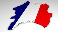
Map of France
by CG Trader
Last crawled date: 1 year, 11 months ago
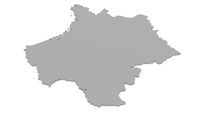
This is a detailed map of France.
Each state is a separate object and they fit seamlessly together.
The states are colored in with 4 different colors (materials).
The model was made in blender v2.79. All state objects are named as follows:
nouvelle-aquitaine
occitanie
provence-alpes-cote-dazur
auvergne-rhone-alpes
pays-de-la-loire
centre-val-de-loire
bourgoone-franche-compt
brittany
normandy
ile-de-france
hauts-de-france
grand-est
french-guinea
corsica The blender file includes two models: Model 1(France as one object)
Vertices: 5408
Polygons: 2726
Tris: 10772 Model 2(France as individual states)
Vertices: 10224
Polygons: 5156
Tris: 20360 The scene has a camera and light and is set up the way you can see in the first render (first image). map of france country world map state various models exterior other fr political province region nation global europe eu french flag
Similar models
cg_trader
$9

Map of Germany
...world map cartography country state bundesland various models exterior other de political province region europe eu nation global
cg_trader
$19
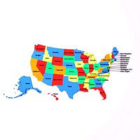
Map of the United States of America USA
...ld map coninent state various models exterior other political province region nation global world united states usa map world map
3dwarehouse
free

Place Jean Jaurès, 42000 Saint-Étienne, Loire, Rhône-Alpes, France
..., 42000 saint-étienne, loire, rhône-alpes, france
3dwarehouse
place jean jaurès, 42000 saint-étienne, loire, rhône-alpes, france
cg_trader
$9

Map of Switzerland
...ntry world map world state canton cartography exterior other swiss ch political province region europe eu nation global world map
3dwarehouse
free

LOIRE 210 - FRENCH NAVY COLORS
... colors (1935) #aeronavale #aircraft #avion #avions #fench #france #marine #navale #navy #plane #planes #seaplane #warbirds #wwii
3dwarehouse
free

Forum, 42000 Saint-Étienne, Loire, Rhône-Alpes, France
...hône-alpes, france
3dwarehouse
place du forum, 42000 saint-étienne, france #42000_saintétienne #forum #france #loire #rhônealpes
cg_trader
$9

Map of Poland
...try world map state cartography various models various models exterior other pl political province region nation global europe eu
3dwarehouse
free

Gare de Chateaucreux, 42000 Saint-Étienne, Loire, Rhône-Alpes
...house
gare de chateaucreux, 42000 saint-étienne, loire, rhône-alpes #42000_saintétienne #gare_de_chateaucreux #loire #rhônealpes
3dwarehouse
free

License Plate France
...license plate france
3dwarehouse
french license plate, pays de la loire #france #license_plate #number_plate #pays_de_la_loire
3dwarehouse
free

LOIRE 210 Seaplane
...rvice only for a short time #air_force #aircraft #avion #france #french #hydravion #marine #navy #plane #seaplane #warbirds #wwii
France
3ddd
free
France flag
...france flag
3ddd
флаг
france flag
3ddd
$1
Gautier France
...france , круглый
столик из коллекции alisa фабрики gautier france. размеры 500х500х390мм
turbosquid
$9

France
... available on turbo squid, the world's leading provider of digital 3d models for visualization, films, television, and games.
turbosquid
$2
France
... available on turbo squid, the world's leading provider of digital 3d models for visualization, films, television, and games.
turbosquid
$2
France
... 3d map of france for download as max, 3ds, dxf, fbx, and obj on turbosquid: 3d models for games, architecture, videos. (1630661)
3d_export
$11
FRENCHIE BULDOG FRANCES
...frenchie buldog frances
3dexport
anillo buldog frances
turbosquid
$5

France flag
...osquid
royalty free 3d model france flag for download as max on turbosquid: 3d models for games, architecture, videos. (1332264)
turbosquid
$70

Map of France
...free 3d model map of france for download as 3ds, max, and obj on turbosquid: 3d models for games, architecture, videos. (1299211)
turbosquid
$25
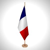
France Flag
...ty free 3d model france flag for download as ma, obj, and fbx on turbosquid: 3d models for games, architecture, videos. (1412764)
3d_ocean
$4
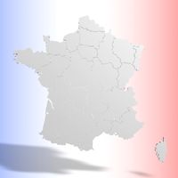
FRANCE 3D MAP
...ap
3docean
3d country france french geography land map object world
3d map of my country, france, with each departments can move.
Map
3d_ocean
$5

Map
...map
3docean
geography map ocean travel world world map
a world map
3d_ocean
$5

Old Map
...old map
3docean
dirty map ocean old map paper pirates rotten travel world map
an old map
turbosquid
$3

Map
... available on turbo squid, the world's leading provider of digital 3d models for visualization, films, television, and games.
3d_ocean
$3

Map of Iran
...map of iran
3docean
flag iran map outline
an outline map of iran
3d_ocean
$2

Map of the USA
...map of the usa
3docean
america flag globe map united states usa
an outline map of the usa
3ddd
$1

Abstract Maps
... город , picture
abstract maps by artist jazzberry blue
3d_ocean
$5

Honduras Map
...honduras map
3docean
3d cinema4d honduras map mapa
honduras map designed in cinema 4d r17
3d_ocean
$2

Map of Germany
...map of germany
3docean
black country europe germany gold map outline red yellow
a simple outline map of germany
3d_ocean
$2

Map of Australia
...map of australia
3docean
australia banner country down under earth flag globe map ocean south
an outline map of australia
3d_ocean
$2

Map of Russia
...of russia
3docean
asia banner earth europe flag globe map russia russian federation siberia sovjet union
an outline map of russia