CG Trader

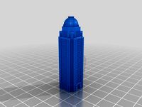
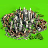
Louisville Kentucky USA 30x30km 3D City Map
by CG Trader
Last crawled date: 1 year, 6 months ago
A DETAILED 3D MODEL CITY MAP OF LOUISVILLE, KENTUCKY, USA: :: Scene Information :: 3dsmax 2015 V-Ray 3.60.03 LWF maps: no texture maps used shader: VRrayMtl the area is 30 x 30 km this model uses OSM data :: Geometry :: metric system [cm] layers are used (buildings, hightway, railroad, water) see preview images for layer structure not all houses are included due to import restrictions or missing OSM data see preview images for covered area :: Materials :: V-Ray materials no texture maps used for this asset :: Lightsetup :: daylight system (included) :: Formats :: 3dsmax 2015 OBJ FBX louisville city cityscape highway state usa topography geography cartography atlas location road travel world map snow kentucky derby exterior landmark
Similar models
cg_trader
$149

Cincinnati Ohio USA 30x30km City Map
... 3dsmax 2015
obj
fbx cincinnati city ohio usa state world map cityscape highway exterior cartography mapping model 3d us landmark
cg_trader
$199

Verona Italy 30x30km 3D City Map
...tem (included) :: formats :: 3dsmax 2015
obj
fbx italy verona venice europe eu euro map city cityscape exterior landmark 3d model
cg_trader
$149

Toronto 30x30km City Map
...tario lake city cityscape map montreal usa road architecture urban business travel aerial modern water guidance exterior landmark
cg_trader
$149
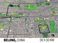
Beijing China 30x30km 3D City Map
...peking city cityscape topography geography atlas location exterior world map cartography country continent travel road china asia
cg_trader
$149

Chemnitz Germany 30x30km 3D City Map
...n germany eu euro merkel city cityscape topography geography atlas location exterior world map cartography country continent road
cg_trader
$149

Cologne Germany 30x30km 3D City Map
...tyscape topography geography map atlas location exterior landscape cologne germany german deutschland eu europe cartography koeln
cg_trader
$149

Birmingham England UK 30x30km 3D City Map
... 2015
obj
fbx birmingham uk england british britain eu pound ireland scotland queen map city cityscape europe irish exterior euro
cg_trader
$149

Bonn Germany 30x30km 3D City Map
...ax 2015
obj
fbx bonn berlin germany german city cityscape topography geography atlas location exterior eu europe euro map
cg_trader
$149

Bremen Germany 30x30km 3D City Map
...en city cityscape topography geography map atlas location exterior deutschland germany german eu euro europe merkel berlin travel
cg_trader
$149

Cottbus Germany 30x30km 3D City Map
...n germany eu euro merkel city cityscape topography geography atlas location exterior world map cartography country continent road
30X30Km
cg_trader
$149

Rome 30x30km City Map
...pe vatican europe eu city cityscape topography geography country road world map location atlas ball shaped soil exterior landmark
cg_trader
$149
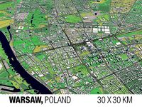
Warsaw 30x30km City Map
...dsmax 2015 obj fbx city cityscape topography geography map atlas location exterior poland polen warschau warsaw warszawa landmark
cg_trader
$149

Toulouse 30x30km City Map
... obj fbx toulouse france french euro eu europe city cityscape topography geography map atlas location exterior landscape landmark
cg_trader
$149

Quebec 30x30km City Map
...ovince quebec cityscape topography geography atlas location exterior world map cartography country continent travel road landmark
cg_trader
$149

Pittsburgh 30x30km City Map
...ghway river landscape guidance road blueprint nature architecture sea direction cartography navigation business exterior landmark
cg_trader
$149

Strasbourg 30x30km City Map
...strasbourg strassburg france french city cityscape eu europe politics alsace euro cash coin paris madrid breton exterior landmark
cg_trader
$149
Toronto 30x30km City Map
...tario lake city cityscape map montreal usa road architecture urban business travel aerial modern water guidance exterior landmark
cg_trader
$149

Salzburg 30x30km City Map
...ia mozart europe euro eu city cityscape topography geography getreidegasse hofburg exterior sporer world map cartography landmark
cg_trader
$149
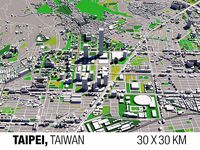
Taipei 30x30km City Map
...sa 101 cityscape republic of china geography atlas location exterior world map cartography country continent travel road landmark
cg_trader
$149

Oslo Norway 30x30km City Map
... europe eu map city cityscape norwegian ocean sea travel skyscraper house exterior euro holmenkollen oslofjord geography landmark
Louisville
3d_export
$49

Louisville Airport 15km
...louisville airport 15km
3dexport
turbosquid
$3

Glass Table 048 - Louisville
... available on turbo squid, the world's leading provider of digital 3d models for visualization, films, television, and games.
3d_export
$199

Louisville kentucky city usa 80km
...t;1. suitable for games, games, education, architecture etc.<br>2. mainly used for town and urban planning, real estate etc
3d_export
$80
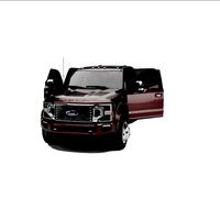
F-450 PLATINUM SUPER DUTY 2021
...trucks are assembled at the kentucky truck plant in louisville kentucky, while medium-duty f-650 and f-750s are assembled at...
thingiverse
free

University of Louisville Logo by AwesomeA
...university of louisville logo by awesomea
thingiverse
university of louisville logo
thingiverse
free

Louisville Cardinal Head by beagle117
...louisville cardinal head by beagle117
thingiverse
a fully colored version of the louisville cardinal head.
go cards!
thingiverse
free

Louisville Logo by eyatsy
...louisville logo by eyatsy
thingiverse
its amazing!
thingiverse
free

Louisville Cardinals Cookie Cutter by the3dprintorium
...he3dprintorium
thingiverse
louisville cardinals sports cookie cutter, also good for sandwiches, pancakes, play-doh, crafts, etc.
thingiverse
free

Louisville Library Downspout by Jpac
...rary downspout. the color version of the model can be viewed here: https://sketchfab.com/models/2b74617ac22649119cdd275243c3b951
thingiverse
free
Aegon Center/Mercer BUilding Louisville, KY by 3DPrintLouisville
...cer building louisville, ky by 3dprintlouisville
thingiverse
model of the aegone center (mercer building) in downtown louisville
Kentucky
turbosquid
$49
Kentucky
... available on turbo squid, the world's leading provider of digital 3d models for visualization, films, television, and games.
turbosquid
$56

Kentucky counties
... available on turbo squid, the world's leading provider of digital 3d models for visualization, films, television, and games.
turbosquid
$15

Kentucky Quarter
... available on turbo squid, the world's leading provider of digital 3d models for visualization, films, television, and games.
3d_export
$15

Kentucky State Quarter 3D Model
...te quarter 3d model
3dexport
kentucky state quarter coin us currency
kentucky state quarter 3d model maideninblack 21456 3dexport
cg_studio
$35

Kentucky Political Map3d model
...egion province
.obj .3ds .max - kentucky political map 3d model, royalty free license available, instant download after purchase.
cg_studio
$40
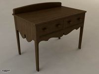
Kentucky Sideboard Table3d model
...studio
.3ds .max .obj .wrl - kentucky sideboard table 3d model, royalty free license available, instant download after purchase.
3d_export
$49

Cincinnati Northern Kentucky Airport 10km
...cincinnati northern kentucky airport 10km
3dexport
3d_export
$15
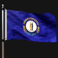
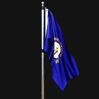
Flag of kentucky
...rmats<br>3ds max 2017<br>3ds max 2020<br>3ds max 2023<br>obj (multi format)<br>fbx ( multi format )
3d_export
$15
Flag of kentucky 02
...rmats<br>3ds max 2017<br>3ds max 2020<br>3ds max 2023<br>obj (multi format)<br>fbx ( multi format )
3d_export
$39

kentucky flag pack
...r the sake of convenience.<br>for any problems please feel free to contact me.<br>don't forget to rate and enjoy!
City
3d_export
$18
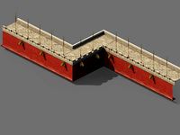
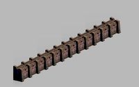
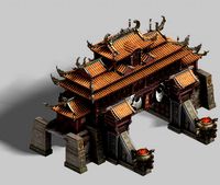
imperial city-city gate-city wall 782
...imperial city-city gate-city wall 782
3dexport
imperial city-city gate-city wall 782<br>3ds max 2015
3d_export
$18
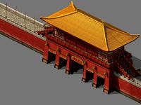
imperial city-city gate-city wall 785
...imperial city-city gate-city wall 785
3dexport
imperial city-city gate-city wall 785<br>3ds max 2015
3d_export
$40
city
...city
3dexport
a city with non-standard architecture.
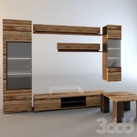
design_connected
$9

City
...city
designconnected
emmemobili city dining tables computer generated 3d model. designed by ferruccio laviani.
3d_export
$18
imperial city-shabak-city wall
...imperial city-shabak-city wall
3dexport
imperial city-shabak-city wall<br>3ds max 2015
3d_export
$18
imperial city-shabak-city gate
...imperial city-shabak-city gate
3dexport
imperial city-shabak-city gate<br>3ds max 2015
3ddd
$1

Диван City
...диван city
3ddd
city , softline
диван city (фирма softline)
3ddd
$1
Гостиная CITY
...гостиная city
3ddd
city , дятьково
гостиная city производства дятьково
turbosquid
$300

City
...ty
turbosquid
royalty free 3d model city for download as 3ds on turbosquid: 3d models for games, architecture, videos. (1235306)
turbosquid
$249

city
...ity
turbosquid
royalty free 3d model city for download as ma on turbosquid: 3d models for games, architecture, videos. (1340610)
Map
3d_ocean
$5

Map
...map
3docean
geography map ocean travel world world map
a world map
3d_ocean
$5

Old Map
...old map
3docean
dirty map ocean old map paper pirates rotten travel world map
an old map
turbosquid
$3

Map
... available on turbo squid, the world's leading provider of digital 3d models for visualization, films, television, and games.
3d_ocean
$3

Map of Iran
...map of iran
3docean
flag iran map outline
an outline map of iran
3d_ocean
$2

Map of the USA
...map of the usa
3docean
america flag globe map united states usa
an outline map of the usa
3ddd
$1

Abstract Maps
... город , picture
abstract maps by artist jazzberry blue
3d_ocean
$5

Honduras Map
...honduras map
3docean
3d cinema4d honduras map mapa
honduras map designed in cinema 4d r17
3d_ocean
$2

Map of Germany
...map of germany
3docean
black country europe germany gold map outline red yellow
a simple outline map of germany
3d_ocean
$2

Map of Australia
...map of australia
3docean
australia banner country down under earth flag globe map ocean south
an outline map of australia
3d_ocean
$2

Map of Russia
...of russia
3docean
asia banner earth europe flag globe map russia russian federation siberia sovjet union
an outline map of russia
Usa
3d_ocean
$2
Map of the USA
...map of the usa
3docean
america flag globe map united states usa
an outline map of the usa
3ddd
free
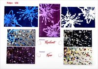
ковры USA
...ковры usa
3ddd
ковер
ковры usa
коллекция:radiante, keno
turbosquid
$100

USA
... available on turbo squid, the world's leading provider of digital 3d models for visualization, films, television, and games.
turbosquid
$50

USA parliament
...quid
royalty free 3d model usa parliament for download as ma on turbosquid: 3d models for games, architecture, videos. (1661719)
3ddd
free

Uttermost USA
... часы
uttermost usa, тип механизма кварцевый, батарейка аа, габаритные размеры 76см х 76см
3d_export
$50
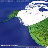
USA 3D Model
...export
united states usa map terrain elevation satellite landscape mountain land topographic dem
usa 3d model braz 21517 3dexport
3d_export
$350

USA states 3D Model
...usa states 3d model
3dexport
usa states
usa states 3d model wickiupinfo 62636 3dexport
turbosquid
$480

USA counties
... available on turbo squid, the world's leading provider of digital 3d models for visualization, films, television, and games.
turbosquid
$150

USA States
... available on turbo squid, the world's leading provider of digital 3d models for visualization, films, television, and games.
turbosquid
$55
Dotted USA
... available on turbo squid, the world's leading provider of digital 3d models for visualization, films, television, and games.