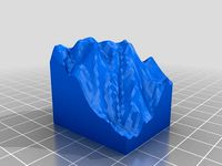
Thingiverse
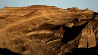
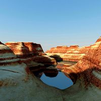
Grand Canyon South Corridor 3d topo by Shapespeare
by Thingiverse
Last crawled date: 3 years ago
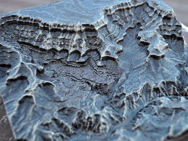
This is a 3d topo map of the south corridor area of the Grand Canyon of the Colorado River. This map covers the area of the Village, Phantom Ranch, and the South Kaibab and Bright Angel trails.
The sample was printed using Prototype Supply PLA on a Printerbot Metal Simple. The print was finished with oil-rubbed bronze color Rustoleum spray paint and dry-brush highlighted with silver Guilder's Paste.
We talked about this finishing technique and a whole lot more about 3d printing on the 3D Printing Today podcast available on iTunes, Stitcher radio or direct from the source at http://threedprintingtoday.libsyn.com/
You can watch a video tutorial about how to make your own miniature mountains at https://www.youtube.com/watch?v=bzwybr65I9o
Complete instructions on how to make models from digital elevation data can be found on my blog at http://www.the3dprintedfuture.com/shapespeare/?p=1
Similar models
thingiverse
free

Monument Valley 3d map by Shapespeare
...s on how to make models from digital elevation data can be found on my blog at http://www.the3dprintedfuture.com/shapespeare/?p=1
thingiverse
free

Crater Lake 3dtopo by Shapespeare
...on how to make models from digital elevation data can be found on my blog at
http://www.the3dprintedfuture.com/shapespeare/?p=1
thingiverse
free

Angel's Landing Zion Canyon National Park by Shapespeare
...s on how to make models from digital elevation data can be found on my blog at http://www.the3dprintedfuture.com/shapespeare/?p=1
thingiverse
free

Cathedral range topo by Shapespeare
...on how to make models from digital elevation data can be found on my blog at
http://www.the3dprintedfuture.com/shapespeare/?p=1
thingiverse
free
The Eastern Sierra Minarets by Shapespeare
...1
the sample print shows the lakes colored in with a blue sharpie (much easier than a dual extruder print plus it looks better)
thingiverse
free
Yosemite Half Dome Trail Map by Shapespeare
...on how to make models from digital elevation data can be found on my blog at
http://www.the3dprintedfuture.com/shapespeare/?p=1
thingiverse
free

Mt Conness (Yosemite) 3d model by Shapespeare
...oday.libsyn.com/
the technique for making this model is detailed in my youtube video https://www.youtube.com/watch?v=t4-ickvyjv0.
thingiverse
free

Hearst Castle from Lidar data by Shapespeare
...nyon nuclear power plant and made available on http://opentopo.sdsc.edu/. the lidar point cloud was gridded to a 0.5m resolution.
thingiverse
free

Kirkwood lift map by Shapespeare
...wood ski area showing all the lifts in contrasting color. there is a single color version for you single extruder folks as well.
thingiverse
free

Grand Canyon Section by thesecapsi
...rth rim to the south rim through the rough middle of the national park
high elevation: 2560m
low elevation: 558m
area: 2500 km2
Shapespeare
thingiverse
free
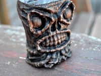
Tikithulu by Shapespeare
...sed coconut shrimp.
eldritch pu pu platters.
the mad strumming of infernal ukuleles.
dead cthulhulu orders another maitai.
thingiverse
free
Crater Lake 3dtopo by Shapespeare
...on how to make models from digital elevation data can be found on my blog at
http://www.the3dprintedfuture.com/shapespeare/?p=1
thingiverse
free

Kilimanjaro by Shapespeare
...he "collectible mountain" version which includes the bast down to sea level see http://www.thingiverse.com/thing:239792
thingiverse
free

Alexander the Printable by Shapespeare
...w.thingiverse.com/thing:239407 and added a base to make it printable with an extruder bot. pretty amazing for a cell phone scan!
thingiverse
free

Pig Skull Sense3d scan by Shapespeare
...by shapespeare
thingiverse
this is what was inside http://www.thingiverse.com/thing:224314 . the rest is headcheese yummmm. . .
thingiverse
free

Tuolumne Meadows to Mt Lyell 3d Topo by Shapespeare
...tuolumne meadows to mt lyell 3d topo by shapespeare
thingiverse
3d topo for zachary
thingiverse
free
Kirkwood lift map by Shapespeare
...wood ski area showing all the lifts in contrasting color. there is a single color version for you single extruder folks as well.
thingiverse
free
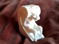
Biltmore Gargoyle by Shapespeare
...florida. he kind of reminds me of harry potter's house elf dobby.
it isn't often you can get that close to a gargoyle.
thingiverse
free
Monument Valley 3d map by Shapespeare
...s on how to make models from digital elevation data can be found on my blog at http://www.the3dprintedfuture.com/shapespeare/?p=1
thingiverse
free
Cathedral range topo by Shapespeare
...on how to make models from digital elevation data can be found on my blog at
http://www.the3dprintedfuture.com/shapespeare/?p=1
Topo
turbosquid
free

Tech Lighting Topo
...ree 3d model tech lighting topo for download as max and blend on turbosquid: 3d models for games, architecture, videos. (1433178)
3d_ocean
$8
Spring Faucet
...accurate, based on real product, detailed and with nice topo.. ...
cg_studio
$79

The Grand Canyon in Arizona United States High Poly3d model
...polygon uv mapped detailed precise exact photo realistic topo toporaphical landscape desert elevation model rocks canyon elevation map .vue...
3d_export
$45

Azteca Mexico Yellow Black FIFA World Cup 1986 Match Ball
...native 3dsmax 2014 - obj - fbx - dae topo - increased polycount around holding edges and uv seams...
3d_export
$45

Tango Espana White Black FIFA World Cup 1982 Match Ball
...native 3dsmax 2014 - obj - fbx - dae topo - increased polycount around holding edges and uv seams...
3d_export
$45
Tango Espana Orange Black FIFA World Cup 1982 Match Ball
...native 3dsmax 2014 - obj - fbx - dae topo - increased polycount around holding edges and uv seams...
3d_export
$45

Tango Italia UEFA European Football Championship 1980 Match Ball
...native 3dsmax 2014 - obj - fbx - dae topo - increased polycount around holding edges and uv seams...
3d_export
$45

Azteca Mexico White Black FIFA World Cup 1986 Match Ball
...native 3dsmax 2014 - obj - fbx - dae topo - increased polycount around holding edges and uv seams...
3d_export
$45

Tango Gol Blue FIFA 1988 Match Ball
...native 3dsmax 2014 - obj - fbx - dae topo - increased polycount around holding edges and uv seams...
thingiverse
free
topo by tabatha23
...topo by tabatha23
thingiverse
topo
Canyon
turbosquid
$19

Canyon
...
turbosquid
royalty free 3d model canyon for download as max on turbosquid: 3d models for games, architecture, videos. (1202190)
turbosquid
$12

Canyon
...
turbosquid
royalty free 3d model canyon for download as max on turbosquid: 3d models for games, architecture, videos. (1285744)
turbosquid
$60
Canyon
... available on turbo squid, the world's leading provider of digital 3d models for visualization, films, television, and games.
turbosquid
$19
Canyon
... available on turbo squid, the world's leading provider of digital 3d models for visualization, films, television, and games.
3d_export
$95

canyon
...canyon
3dexport
simple rendering of the scene file
3d_export
$65

canyon
...canyon
3dexport
simple rendering of the scene file
3d_export
$65
canyon
...canyon
3dexport
simple rendering of the scene file
3d_export
$65
canyon
...canyon
3dexport
simple rendering of the scene file
3d_export
$65

canyon
...canyon
3dexport
simple rendering of the scene file
3d_export
$65

canyon
...canyon
3dexport
simple rendering of the scene file
Corridor
turbosquid
$13

Corridor
...urbosquid
royalty free 3d model corridor for download as c4d on turbosquid: 3d models for games, architecture, videos. (1146452)
turbosquid
$80

corridor
...alty free 3d model corridor for download as max, obj, and fbx on turbosquid: 3d models for games, architecture, videos. (1369406)
turbosquid
$9
Corridor
... available on turbo squid, the world's leading provider of digital 3d models for visualization, films, television, and games.
3d_export
$5
Corridor
...rridor
3dexport
corridor suitable for designing restaurants or modern industrial spaces<br>rhino 5, fbx, dwg<br>12mb
3d_export
$65

corridor
...corridor
3dexport
simple rendering of the scene file
3d_export
$65

corridor
...corridor
3dexport
simple rendering of the scene file
3d_export
$5

sifi corridor
...sifi corridor
3dexport
sifi corridor made with blender personal lisence only
turbosquid
$12

Space Station corridors, spaceship landing sites, sci-fi scenes, space corridors, sci-fi corridors, corridors, labs
...ridors, sci-fi corridors, corridors, labs for download as max on turbosquid: 3d models for games, architecture, videos. (1552442)
3d_export
$5
sci fi corridor
...sci fi corridor
3dexport
sci fi corridor
3d_export
$10

Anime Corridor
...anime corridor
3dexport
South
3ddd
$1

South Beach Люстра
... beach , south beach
http://www.wired-designs.com/ceiling/south-beach-ceiling/
3ddd
free
South Africa 2010
...south africa 2010
3ddd
статуэтка
south africa 2010
3d_export
$5

table south beach
...table south beach
3dexport
table south beach kare design
3d_export
$5

console south beach
...console south beach
3dexport
console south beach kare design
turbosquid
$7

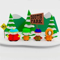
South Park
...ty free 3d model south park for download as max, obj, and fbx on turbosquid: 3d models for games, architecture, videos. (1230683)
turbosquid
$89
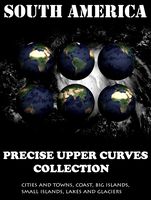
South America
... available on turbo squid, the world's leading provider of digital 3d models for visualization, films, television, and games.
3d_ocean
$19
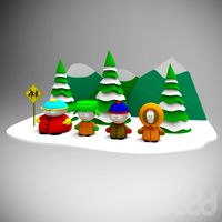
South Park Low Poly
...south park low poly
3docean
cartoons character low lowpoly poly south southpark
south park low poly
3ddd
$1

кукла Timmy South Park
... timmy , кукла
кукла funko
timmy burch из south park
3ddd
free
South Park фигурка
...south park фигурка
3ddd
south park
пластиковая фигурка героев мультсериала "южный парк".
52027 полигонов.
3ddd
free

Lexington 11 South
... profile lamp table
сайт производителяhttp://www.lexington.com/collections/11-south.cfm
Grand
3ddd
$1
GRAND (Grand)
...grand (grand)
3ddd
grand , угловой
мягкий уголок мебельной фабрики grand (модель grand)
3ddd
$1

Grand
...
grand , katrin , круглая
кровать фабрики grand
3ddd
$1
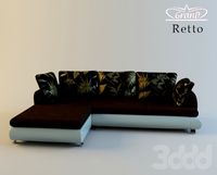
Grand / Retto
...grand / retto
3ddd
grand , угловой
диван от grand коллекция retto
3ddd
$1
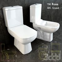
Grand toilet
...nd , rosa , унитаз
унитаз гранд / grand тм rosa
3ddd
$1

Умывальник Grand
...умывальник grand
3ddd
умывальник , grand
умывальник grand 755 х 465 мм со смесителем
3d_export
$80
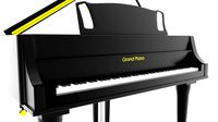
grand piano
...grand piano
3dexport
grand piano detailed
3ddd
$1
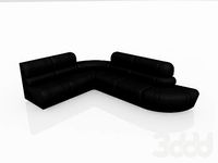
KREDO (Grand)
... kredo , угловой
диван в столовую фабрики мягкой мебели grand (модель kredo)
3ddd
$1
Insolito grande
...insolito grande
3ddd
insolito
insolito grande
240х85х73
3ddd
$1
Grand royal
...grand royal
3ddd
grand royal под tv
3ddd
free

Grande Forge
...grande forge
3ddd
grande forge
gf bed