3DWarehouse
gare Montparnasse, railway Station in 1852
by 3DWarehouse
Last crawled date: 1 year, 9 months ago
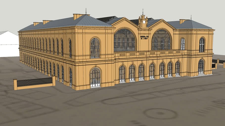
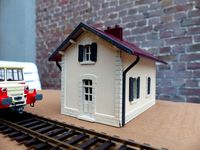
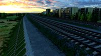
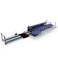
A bit of History This is the second Montparnasse railway station replacing the first one built in 1840 (then called embarcadère du Maine) just outside the Paris' walls. This station has been built between 1848-1852 and was known first as 'gare de l’Ouest rive Gauche' (St Lazare was the 'gare de l’ouest rive droite') before to be named gare Montparnasse.2] The station architects were Victor Lenoir and Alphonse Baude (chief Engineer at the Compagnie de l’ouest). the hall (and iron floors) is from Eugene Flachat, The ornamental statues on the clock are from Hubert Lavigne and are supposed to represent the 'industry' and the 'agriculture'. A viaduct was also built (By Baude) to connect the station with the existing railway outside the Paris wall. The station has gone thru 2 major expansions: In 1863, the hall was expanded (it lost its original masonry portal at this time) as well as the lateral pavilions. External staircases and access ramps from Place de Rennes to expanded upper yards were added at this time (Internal staircases then were removed).3] Rue du depart was also enlarged from 10m to 12m.2] Circa 1898 (in time for the 1900 Universal exhibition), yards and access ramps were reversed (access from Bd Edgar Quinet), and additional tracks and platforms were added.6]7] The station has been demolished circa ~1969, the existing one built in 1965 is the third one. The current site is occupied by the Maine-Montparnasse tower and commercial center built in 1969-1973. The model (1852 -1863) Station It is mainly designed from the Moniteur des architectes drawings.1] Some detais like the upper cornice or the support walls for the hall could not have been built as per drawing. Those are then inferred of postcards, lithographies,10]11] drawings,12] and photographies, including one of Marville circa 1871 (after la Commune), one of the Roger Viollet/Leon Levy collection circa 1860 ( Vue panoramique prise du chemin de fer de l'Ouest ) and others. Mashable provides good definition pictures of the 1895 accident. 1] has been cross checked with subsequent drawings like found in 6] (1898 alteration) or 15] (paper on the 1895 accident). Exact dimensions coming from 1] are reported in 'dimension' layer. Internal elements (such as the Polonceau trusses for the Hall, and inside partitions), and other complex elements, such as the statues (model based on another one from Friskie Dingo ) are also in separate layers. Shape and size of the lower and upper yards, as well as ancillaries buildings are inferred of the Paris cadastral map, a 1852 district map 16], a circa 1860 military map ('carte d'etat major' map available at IGN) and are cross checked with the roger viollet picture and 1]. Viaduct (before 1899) Foot print (arches…) from Paris cadastral maps, some dimensions from 17] and shape of the arches from 2]3]17] and postcard 468 . dimensions provided in 14] matches only for the central pedestrian arch width. Terrain The topography has been severely modified in the 1965s....so the original topography has been inferred of elevation as provided by IGN (for location known unmodified, such as Bld Montparnasse), and contour lines as provided by the 1860 military map (it provides the normal to the isophyses). street widths are provided by 5]. The building is mapped on the map provided by 15] (which presents the 1863 alteration) with some 1830-1860 cadastral information overlay. Rail level is at 57.32m, street level (Montparnasse boulevard) at 48.29m, as reported by 15], 50m70 on Bld Edgar Quinet as reported by 17]. Also, 14] reported that Avenue du Maine has been lowered by 1m to provide enough clearance below the viaduc. 1] Moniteur des architectes , 9ieme volume, 15 Janvier 1852 planches 97 a 108 2] Henri Gourdon de Genouillac, Paris à travers les siècles, tome 5, Paris, 1882, p 140 3] Journal des chemins de fer, des mines et des travaux publics, 1865, p208 5] Ville de Paris, Nomenclature des voies publiques et privées, avec la date des actes officiels les concernant. Chaix Paris, 1881 6] Le Magasin pittoresque, Les transformations de la gare Montparnasse, 1898, p396 7] Le Chemin de fer, 8ieme annee, numero 359, 19 Aout 1899, p 3 8] Auguste Charles Joseph Vitu, Paris: 450 dessins inédits d'après nature, Maison Quantin, 1889, p275 9] Léo Lespès,et Charles Bertrand, Paris-album: historique et monumental divisé en vingt arrondissements (mauvaise gravure de la gare en 1852) 10] Adolphe Joanne Paris illustré: nouveau guide de l'étranger et du parisien, Hachette, 1863, p CVI (gare avant 1863) 11] Adolphe Joanne, Environs de Paris illustrés, Hachette 1872, 106 (station after 1863, but portal before 1863 p107) 12] Léon Leymonnerye, Gare de l’ouest (depart et place du Maine), 1876, Musee carnavalet, Paris 13] Alfred Delveau , Histoire anecdotique des barrières de Paris, E. Entu Paris, 1865 p.265 14] Daly, Revue generale de l'architecture et des travaux publics, 8ieme volume, Paris 1849, p 45-46 15] Le Génie civil : revue générale des industries françaises et étrangères, tome 28, n1, n699, 2 Novembre 1895 p1-5 16] Apur, Montparnasse: Analayse et diagnostic du quartier Montparnasse, 2005 17] Jules Hervieux, Le chemin de fer métropolitain municipal de Paris. Ligne circulaire n° 2 (rive gauche), ligne n° 3, du Boulevard de Courcelles à Ménilmontant. Résultats de l'exploitation. Tome2 Atlas, 1908, planche 18 #chemin_de_fer #embarcadere #gare #histoire #Montparnasse #ouest #Paris
Similar models
3dwarehouse
free

Gare de l’avenue Foch Paris
... integrated into the chemin de fer de petite ceinture. in 1988, today's tunnel station with the rer c was put into operation.
3dwarehouse
free

Batiment de gare
...batiment de gare
3dwarehouse
batiment voyageur pour les chemins de fer #gare #halte #rail #railway #station #train #tren
3dwarehouse
free

Tour près du quartier Montparnasse, Paris (XVème arrondissement), FRANCE
...le xvème arrondissement. la tour et la gare montparnasse sont à une centaine de mètres. #15 #france #paris #skyscraper #tour #xiv
3dwarehouse
free
Ligne de chemin de fer et route
...
c'est un dessin en 3d qui représente : une ligne de chemin fer, une route et 2 gares. #gares #ligne_de_chemin_de_fer #route
3dwarehouse
free

Parc Touristique des Combes - La Gare
...parc touristique des combes - la gare
3dwarehouse
gare du chemin de fer des crouillottes.
3dwarehouse
free

Ancienne Gare de Douvres-la-Délivrande
...té condamnées. #ancienne #basse #caen #calvados #chemin_de_fer #douvres #désaffectée #france #gare #mer #normandie #rail #railway
3dwarehouse
free

La Gare SNCF d'Avrechy
...édifice des chemins de fer du nord. halte sncf de la ligne paris-amiens. modèle 3d créé par florian robardet #avrechy #gare #sncf
3dwarehouse
free
Chemin de Fer Touristique des Combes Gare du Creusot
...chemin de fer touristique des combes gare du creusot
3dwarehouse
gare de départ circuit des deux vallées.
3dwarehouse
free
Gare SNCF d'Argentan
...tel et briouze). elle se situe ainsi sur les lignes 2, 6 et 7 du ter basse-normandie. #gare #gare_sncf #gare_sncf_dargentan #sncf
3dwarehouse
free

Ancienne gare de Cambes
...é d'antant. #ancienne #basse #caen #calvados #cambes #chemin_de_fer #désaffectée #france #gare #mer #normandie #rail #railway
Montparnasse
3ddd
free

EICHHOLTZ MONTPARNASSE
... кресло , montparnasse
модель кресла eichholtz montparnasse
turbosquid
$69

Astro Montparnasse Exterior Wall 0561
...del astro montparnasse exterior wall 0561 for download as max on turbosquid: 3d models for games, architecture, videos. (1294668)
3ddd
$1

VAUGHAN / montparnasse bouillotte
...vaughan / montparnasse bouillotte
3ddd
vaughan
настольная лампа с абажуром red, в каталоге есть green и black
3d_sky
free

EICHHOLTZ MONTPARNASSE
...eichholtz montparnasse
3dsky
eichholtz chair
model chairs eichholtz montparnasse
3d_sky
$8
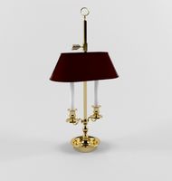
VAUGHAN / montparnasse bouillotte
...vaughan / montparnasse bouillotte
3dsky
table lamp with a shade of red, green and black are directory
3dbaza
$4
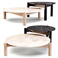
Cassina 535 Plateau Coffee Tables (321764)
...1937 for the parisian studio of charlotte perriand in montparnasse the base of the table a plateau is made...
cg_trader
$7

Eichholtz Chandelier Montparnasse
...ontparnasse
cg trader
eichholtz chandelier montparnasse 3d , available in max, obj, mtl, 3ds, fbx, ready for 3d animation and ot
cg_trader
$6

CHANDELIER MONTPARNASSE Eichholtz
...hholtz
cg trader
chandelier montparnasse eichholtz 3d chandelier, available formats max, obj, fbx, ready for 3d animation and ot
cg_trader
$10

Montparnasse the clock houses of the world
...ock houses of the world
cg trader
montparnasse the clock houses of the world 3d model, available formats max obj 3ds fbx stl dae
cg_trader
$20

Armchair Montparnasse Visionnaire
...armchair montparnasse visionnaire
cg trader
manufacturer website - https://www.visionnaire-home.com/
1852
turbosquid
$8

Human-1852
...turbosquid
royalty free 3d model human-1852 for download as on turbosquid: 3d models for games, architecture, videos. (1170142)
turbosquid
$40

1852 Win
... available on turbo squid, the world's leading provider of digital 3d models for visualization, films, television, and games.
3ddd
$1

Vittorio Grifoni 1852
...vittorio grifoni 1852
3ddd
vittorio grifoni
удачного рендера)
3d_export
$5

low-poly spinosaurus
...3d model of a spinosaurus. verts : 1920 faces: 1852 the 3d model have simple materials with principled bsd...
3d_export
$5

Sword
...of three meshes. triangulated mesh<br>*vertices - 691 *edges - 1852 *faces - 1164 *triangles - 1164<br>*modeling - blender *baking...
3d_export
$25
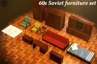
60s soviet furniture set
...of triangles is 12656.<br>sofa - 1264<br>bed - 1224<br>armchair01 - 1852lt;br>armchair 02 - 1784<br>table01 - 332<br>table02 - 336<br>table03 - 542<br>cupboard01...
3d_export
$199

mercedes-benz e-class estate 2021
...in real size length - 4923 mm width - 1852 mm height - 1469 mm wheelbase - 2939 mm...
3d_export
$37

dinosaurs pack
...: 1437 faces: 1408 spinosaurus verts : 1920 faces: 1852 stegosaurus verts : 1209 faces: 1188 triceratops verts :...
3d_export
$29

shield set
...polygon.<br>........................1092 vertices.<br>shield_2............1844 polygon.<br>.........................990 vertices.<br>shield_3............1864 polygon.<br>.........................1000 vertices.<br>shield_4............1736 polygon.<br>..........................936 vertices.<br>shield_5.............1672 polygon.<br>..........................904 vertices.<br>shield_6.............1852 polygon.<br>..........................994 vertices.<br>shield_7.............1820 polygon.<br>..........................1089 vertices.<br>shield_8.............1946 polygon.<br>..........................1171 vertices.<br>4096*4096 texture<br>obj,fbx,blend format model.<br>uv...
3d_export
$199

mercedes-benz e-class 2021
...is made in real size<br>length - 4923 mm<br>width - 1852 mm<br>height - 1469 mm<br>wheelbase - 2939 mm<br>no smooth: 234762...
Gare
thingiverse
free

Gare Brio - Thingiverse Station by 7h3ophile
...gare brio - thingiverse station by 7h3ophile
thingiverse
une gare adaptée pour jeu brio
thingiverse
free
Jouef Gare 1960 by Murphy25
...st la gare jouef de 1960 reproduite en 3d en ho. pour le n il suffit dans cura de mettre une échelle à 55% pour l'avoir en n.
thingiverse
free
18650 4s holder by gare
...e the cable ties in a cross pattern using them to also help the cables stay put. apply a dab of hot glue in the hole and voila :)
thingiverse
free

Whirlpool JQ280 Repair by gare
...le piece on ebay for about 25 euros not including shipping, i decided to give it a go with the printer, and guess what, it works!
thingiverse
free

Quai de gare - Station platform Marklin Z échelle scale: 1/220 by phildc
...ure model modelisme ferroviaire gare station scale 3d escalier stairs quai perron platform voie rail track mini club openscad stl
thingiverse
free

Luchrone Prototype Reims by KILLY
...killy thingiverse luchrone de reims fr place de la gare ...
thingiverse
free
Maison garde barriere
...company in ho scale. the plans are from the gare et batiments ferroviaires book. next to the the walls...
thingiverse
free

coquetier by boldorman
...œufs à la coque c'est moins risqué ^_^ mais gare à la crise de foie si vous en mangez...
sketchfab
$15

"Le jardin des imaginaires", Bordeaux (33)
...l’âme du quartier : par sa proximité avec la gare saint-jean et le fleuve, c’est un lieu d’échange et...
sketchfab
$13

Ujarma Fortress, Georgia
...gombori pass through tsiv-gombori range in the historical-geographical province gare kakheti. the fortress consisted of two parts: the upper...
Railway
archibase_planet
free
Railway
...tact wire railroad contact wire railway line
railway contact wire n210814 - 3d model (*.gsm+*.3ds) for exterior 3d visualization.
3d_export
$9

railway stations
...railway stations
3dexport
railway stations<br>сollection of four railway stations.
turbosquid
$10
Railway
...yalty free 3d model railway for download as max, obj, and fbx on turbosquid: 3d models for games, architecture, videos. (1283992)
turbosquid
$29

railway
... available on turbo squid, the world's leading provider of digital 3d models for visualization, films, television, and games.
3d_export
$5

railway tank
...railway tank
3dexport
low-poly railway tank model
3d_export
$65

railway
...railway
3dexport
simple rendering of the scene file
3d_export
$65

railway
...railway
3dexport
simple rendering of the scene file
3d_export
$65
railway
...railway
3dexport
simple rendering of the scene file
3d_export
$65
railway
...railway
3dexport
simple rendering of the scene file
3d_export
$65
railway
...railway
3dexport
simple rendering of the scene file
Station
3d_export
$5
station
...station
3dexport
station
archibase_planet
free
Station
...station
archibase planet
railroad station railway station bay
railway station n160707 - 3d model for interior 3d visualization.
archibase_planet
free
Station
...station
archibase planet
intercom station equipment
intercom station - 3d model for interior 3d visualization.
archibase_planet
free
Station
...station
archibase planet
station
station n260108 - 3d model (*.gsm+*.3ds) for interior 3d visualization.
3d_export
$5
Station
...station
3dexport
low poly bus station
archibase_planet
free
Station
...station
archibase planet
building station construction
station n170708 - 3d model(*.gsm+*.3ds) for interior 3d visualization.
archibase_planet
free

Station
...station
archibase planet
bus station bus stop
station 1 - 3d model (*.gsm+*.3ds) for interior 3d visualization.
archibase_planet
free
Station
...station
archibase planet
bus station bus stop
station 2 - 3d model (*.gsm+*.3ds) for interior 3d visualization.
archibase_planet
free
Station
...station
archibase planet
bus station bus stop
station 3 - 3d model (*.gsm+*.3ds) for interior 3d visualization.
3d_ocean
$19
Space station
...space station
3docean
space station
space station