Thingiverse
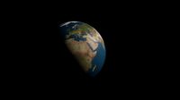
Earth topography with coastlines by jeffwinterbourne
by Thingiverse
Last crawled date: 4 years ago
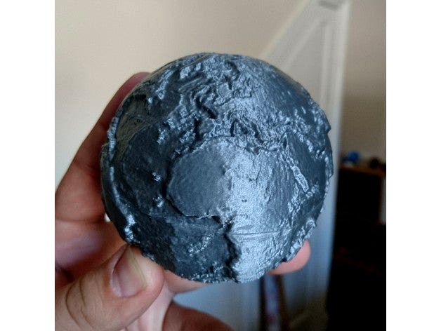
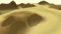
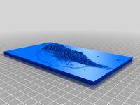
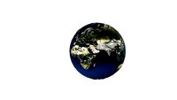
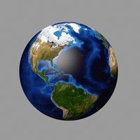
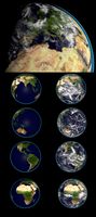
This is a high detail globe of Earth's topography (highly exaggerated), designed as an educational tool. Several others exist on Thingiverse already - the difference of this one is that the outline of the continent has been raised slightly so that familiar coastlines can be picked out, making it better for teaching.
Included are two hollow hemispheres which print with minimal plastic, without supports. Also included a complete sphere for anyone who wants to print using a more advanced method or to use this model for a different purpose.
Update: if you like a challenge, try the model which opens to reveal the core with embedded magnets (https://www.thingiverse.com/thing:3561651) or crustal thickness (https://www.thingiverse.com/thing:3899023)
Suggested things to study:
Hawaii, in the Pacific Ocean, is part of a long chain of submarine mountains. These are volcanoes, formed as the ocean plate passes over an unusually hot part of the Earth's interior (a "hot spot" or mantle plume). How many of these tracks can you find?
Mountain belts - these form at convergent plate boundaries, where one tectonic plate collides with another. The Himalayas are a great example of this; how many more can you find?
Ocean trenches exist where one plate subducts (descends beneath) another, giving a band of extremely deep ocean. The deepest of these is the Mariana trench, in the northwest of the Pacific ocean. Where else can you find subduction happening? Why are the trenches often next to a belt of mountains?
A ridge runs down the middle of the Atlantic Ocean - this is where oceanic crust is created. Where are the other mid-ocean ridges?
Similar models
3dwarehouse
free
Subducting Continent
...dwarehouse
3d model of an oceanic crust subducting under a continental crust - creating a mountain range, trench, and volcanoes.
thingiverse
free
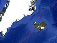
Mid-Atlantic Ridge with Iceland and Greenland by xun
... and form ocean mid-ridge. you also can see greenland is covered with ice sheet in this model.
exaggeration factor: 10x, 30x, 50x
thingiverse
free

Textured Earth by bld
...verse.com/thing:14070 and http://www.thingiverse.com/thing:11660
now available on github: https://github.com/bld/textured-earth
thingiverse
free
accessories deadpool by buho29
...u pass the belts) with hot glue
redrawing the magnificent design https://www.thingiverse.com/thing:1738270
source file disponible
thingiverse
free

Experimental mountain print by dazzadazzadazzadazza
...ingiverse
optimized for makerbot mini build plate.
mountain sample to see how well the printer performs with the complex ridges.
3dwarehouse
free
rendering terrain desert
...#hills #location #mountains #photo_texture #projected_texture #rendering #sandbox_tools #setting #terrain #topo #topography #zone
3dwarehouse
free

Mountain Ridge Junior High School
...mountain ridge junior high school
3dwarehouse
a 3d model for google earth of mountain ridge junior high school
thingiverse
free
Hot Wheels Track Quarter Loop by malamaker
... full loop depending on how big of a loop you are looking for.
if you need a loop base: https://www.thingiverse.com/thing:2781202
thingiverse
free

Iron Creed Trench (Trench Blocker) by Ravencos27
...ent: https://www.thingiverse.com/thing:4851319
design inspired by games workshop forgeworld trenchworks. designed purely for fun.
3dwarehouse
free
model of coastline view
...model of coastline view
3dwarehouse
a beautiful view from the coastline of the pacific. #beautiful #cool #nice #view
Coastlines
3d_export
$20

Lighthouse 3D Model
...l emit lamp architecture lantern
lighthouse 3d model download .c4d .max .obj .fbx .ma .lwo .3ds .3dm .stl firdz3d 110602 3dexport
3d_export
free
castle of good hope
...here from the air, is also the image proudly displayed the military, air force and navy and also on rank insignia of the military
3dfindit
free
COASTLINE
...coastline
3dfind.it
catalog: zero sweden
thingiverse
free
Coastline Arm Protectors
...coastline arm protectors
thingiverse
coastline frame arm protectors
will update with new files as i finish them
thingiverse
free
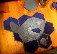
Planetary empires - coastlines ++ by Paaar
...d a coastline using planetary empires hexes. added some more terrain types.
picture showing some examples with the water painted.
unity_asset_store
$5
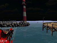
CoastLine Pier & Dock Set
...h the coastline pier & dock set asset from grim3d. find this & other landscapes options on the unity asset store.
thingiverse
free

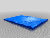
Texas (trimmed coastline) by 7777773
...e ocean water layer and then added a few mm to the z layer without changing x and y, which stretches out the visible peaks a bit.
thingiverse
free

Walton-on-the-Naze by Field_Studies_Council
....
shows clearly the difference between cliff profile for the defended (southern) and undefended (northern) sections of coastline.
thingiverse
free
Taiwan - my country by xun
...actor: 5x
i raised the height of the ground to let the coastline be printed easily.
the thinker base one is easier to be printed.
Topography
3d_export
$18
song dynasty-topography-pier
...song dynasty-topography-pier
3dexport
song dynasty-topography-pier<br>3ds max 2015
3d_export
$17
High quality earth animated 3D Model
...world globe relief space orbit continent ocean sea floor topography geography topographic geographic animation shaded spinning high quality earth...
3d_export
$17

Earth High Quality 3D Model
...world sphere relief space orbit continent ocean sea floor topography geography topographic geographic animation shaded spinning earth high quality...
3d_export
$9

Earth High Quality 3D Model 3D Model
...world sphere relief space orbit continent ocean sea floor topography geography topographic geographic animation shaded spinning earth high quality...
3d_export
$17
High Quality Earth Over The Night 3D Model
...world sphere relief space orbit continent ocean sea floor topography geography topographic geographic animation shaded spinning high quality earth...
cg_studio
$33
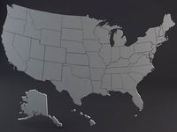
USA States3d model
...states country nation geography atlas chart usa us political topography election education map silhouette contour edge .wrl .stl .obj...
3d_export
$25

Earth and Moon 3D Model
...world sphere relief space orbit continent ocean sea floor topography geography topographic geographic animation shaded spinning terrain landscape surface...
cg_studio
$79

The Grand Canyon in Arizona United States High Poly3d model
...states high poly3d model cgstudio grand canyon arizona map topography terrain 3d model usa united states united states of...
thingiverse
free
Station Total Topography
...station total topography
thingiverse
topography station total
thingiverse
free
topography of Medford OR by Steamtowers
...topography of medford or by steamtowers
thingiverse
3d printable topography of medford or
Earth
3d_export
$5
earth
...earth
3dexport
earth with textures
3d_ocean
$5

Earth
...tic world science sphere world terra world illustrations world map
a beautiful model of earth complete with high resolution maps.
3d_export
$5
earth
...earth
3dexport
earth pbr texture
3d_ocean
$9
Earth
...osphere blue chikyuu clouds earth erde globe moon planet satellite solar space system terra tierra universe
realistik model earth
3d_export
free
earth
...earth
3dexport
3d_ocean
$4
Earth
... latest map most new planet plygon ready top world
earth 3d model is available in all major 3d formats like fbx, obj, mb and lxo.
3d_ocean
$9

Real Earth
...ce sphere world terra world illustrations world map
a beautiful model of earth complete with high resolution maps, and materials.
3d_ocean
$9

The Earth
...ay world world map
3d models for the earth globe you can use it with any project file included 3d max file format obj file format
3d_ocean
$9
Earth
...le formats: .c4d, .obj, .3ds - materials included - 4 textures (earth maps: 24000?×?12000px, clouds:8192?×?4096 px) - atmosphe...
3d_export
$65

earth
...earth
3dexport
simple rendering of the scene file