CG Trader

Charlotte
by CG Trader
Last crawled date: 1 year, 12 months ago
This is exact and accurate to scale 3D city model of Charlotte, North Carolina and its surrounding area based on GIS data (September 2021) PACKAGE CONTENTS Fully customizable - you can select only the options you need! This product includes scenes of various sizes and formats 80 x 80 km - Complete scene (city and surrounding area) 40 x 40 km - Full city extents (incl. airport) 15 x 15 km - Charlotte Douglas International Airport (CLT) Any custom area size (please request before buying) File formats (software supported) MAX - Autodesk 3dsMax FBX, OBJ, DAE - Exchange Formats GLTF, GLB - Games, Web, AR/VR (request) UNITYPACKAGE - Unity 3D 3DM - Rhino 3D SKP - SketchUp RVT - Autodesk Revit (request) STL - 3D Print (request) C4D - Cinema4D BLEND - Blender MA, MB - Autodesk Maya DWG, DXF - Autodesk AutoCAD BASIC OPTIONS (included with the purchase) KEY BENEFITS 24/7 customer support 40 detailed landmarks + regular updates and improvements 100% buildings coverage from buildings footprint polygon geometries in all 50 U.S. States Buildings, landuse areas, roads and railways split by type (layers / named objects) The surface is flat, easy to add details and edit geometry (terrain on request) Realistic low-poly trees and forests (max, fbx included, other formats on request) Product is ready to render out-of-the-box (3dsmax + corona renderer) PRESENTATION IMAGES 4K high-resolution realistic renderings (refer to images for level of detail or request close-ups) Rendered in 3dsMax (other softwares requires its own rendering settings) MATERIALS Trees, vegetation, landuse and airport surface with the textures assigned Buildings are UVW mapped, split by material IDs, no textures assigned CUSTOM OPTIONS (available at a special price - please request before buying) TOPOGRAPHY TERRAIN Up to 1 meter accuracy raw terrain object (USGS 3D Elevation Program) Multiple LODs optimized for the best polycount/details balance Countour lines (up to 1 meter interval) High-resolution (up to 20cm accuracy) sattelite or surface texture Buildings and roads placed on the optimized terrain OTHER EXTRAS On-demand custom update Crop to custom area size or slice to tiles Procedural textures assigned to all buildings Individual buildings and streets (with address and/or name) Administrative boundaries of all levels (named polygons or outlines) Road and railway splines for traffic animation Public transport stops with names CONTACT US Discounts 24/7 customer support Custom and on-demand options Adjustments and improvements city map model area building center skyline landscape topography suburb downtown skyscraper airport extents urban street sketchup charlotte north carolina city street city building city landscape city map city skyline city street
Similar models
cg_trader
$299

Bucharest
...skyscraper sketchup exterior cityscape street exterior city street city building city landscape city map city skyline city street
cg_trader
$399

Yekaterinburg
...rior cityscape street exterior city street city building city landscape city map city scene city skyline city street street scene
cg_trader
$399
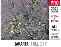
Jakarta
...port extents urban street park sketchup jakarta exterior cityscape city building city landscape city map city skyline city street
cg_trader
$299

Belgrade
...treet park sketchup exterior cityscape street exterior city street city building city landscape city map city skyline city street
cg_trader
$399

Guangzhou
...ino unity airport park exterior cityscape china map city building city landscape city map city skyline city street rhino building
cg_trader
$299

Launceston
...launceston tasmania exterior cityscape street exterior city street city building city landscape city map city skyline city street
cg_trader
$299
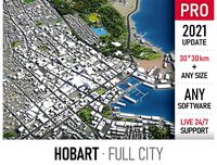
Hobart
... tasmania australia exterior cityscape street exterior city street city building city landscape city map city skyline city street
cg_trader
$399

Hamburg
...dscape topography exterior cityscape city building city landscape city map city skyline city street exterior house house exterior
cg_trader
$399

San Jose - Costa Rica
...extents street park sketchup exterior cityscape street exterior city street city building city landscape city skyline city street
cg_trader
$299

Victoria
...hup victoria canada exterior cityscape street exterior city street city building city landscape city map city skyline city street
Charlotte
design_connected
$16
Charlotte
...charlotte
designconnected
horm charlotte armchairs computer generated 3d model. designed by mario botta.
3ddd
free
Спальня Charlotte
...я charlotte
3ddd
asnaghi , charlotte
итальянская мебель charlotte, производитель asnaghi
turbosquid
$59

Charlotte
...osquid
royalty free 3d model charlotte for download as blend on turbosquid: 3d models for games, architecture, videos. (1303011)
3ddd
$1

bellavista - charlotte
...bellavista - charlotte
3ddd
bellavista , charlotte
80x95x97h
3ddd
free

Essepi Charlotte
...
essepi , charlotte
кровать essepi charlotte 03. высокая детализация, ~300 тыс. поликов.
3ddd
$1
Baxter / Charlotte
...baxter / charlotte
3ddd
baxter
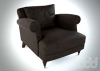
кресло baxter charlotte
3ddd
$1

Кресло Porada Charlotte
...кресло porada charlotte
3ddd
porada , charlotte
кресло porada charlotte
3ddd
$1
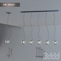
De majo Charlotte
...de majo charlotte
3ddd
charlotte , de majo
светильник charlotte by de majo.
3ddd
$1

Maries corner Charlotte
...er , charlotte , барный
maries corner charlotte
turbosquid
free

Charlotte valve
...id
free 3d model charlotte valve for download as stl and dwg on turbosquid: 3d models for games, architecture, videos. (1531456)