CG Trader
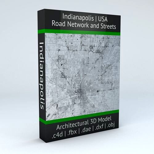
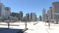
Indianapolis Road Network and Streets
by CG Trader
Last crawled date: 1 year, 9 months ago
this model is based on real data therefore this is a realistic road network and streets setup of Indianapolis, USA 2 objects included | 1. roads and streets 2. squares and plazas UV mapped with overlapping UVs the model is positioned on a flat surface (road network is on the “floor” - no elevation data included) geometry is polygonal quads and tris model is untextured and renders fast this 3D model is/can be licensed (commercial use is fine) under Creative Commons Attribution-ShareALike 2.0 (CC-BY-SA) license buildings and streets data from OpenStreetMap / www.openstreetmap.org Attribution : © OpenStreetMap contributors / http://www.openstreetmap.org/copyright POINTS/VERTS : 3160808
POLYGONS : 3207685 .c4d - native format .fbx - v7.1 .dae - v1.5 .dxf .obj indianapolis usa united america road network system streets infrastructure architectural map cartography city gps navigation roads squares realistic topology states street architectural street city street city map city street city streets united states usa map
POLYGONS : 3207685 .c4d - native format .fbx - v7.1 .dae - v1.5 .dxf .obj indianapolis usa united america road network system streets infrastructure architectural map cartography city gps navigation roads squares realistic topology states street architectural street city street city map city street city streets united states usa map
Similar models
cg_trader
$29

Baltimore Road Network and Streets
... realistic topology architectural street architectural street city street city map city street city streets united states usa map
cg_trader
$29

Orlando Road Network and Streets
... roads squares realistic topology street architectural street city street city map city street city streets united states usa map
cg_trader
$29
Philadelphia Road Network and Streets
... roads squares realistic topology street architectural street city street city map city street city streets united states usa map
cg_trader
$29

Detroit Road Network and Streets
... roads squares realistic topology street architectural street city street city map city street city streets united states usa map
cg_trader
$29

Miami Road Network and Streets
...alistic topological architectural street architectural street city street city map city street city streets united states usa map
cg_trader
$29

Dallas Road Network and Streets
... roads squares realistic topology street architectural street city street city map city street city streets united states usa map
cg_trader
$29

Houston Road Network and Streets
... roads squares realistic topology street architectural street city street city map city street city streets united states usa map
cg_trader
$29

Boston Road Network and Streets
...es realistic topological topology street architectural street city street city map city street city streets united states usa map
cg_trader
$29

Roswell Road Network and Streets
... roads squares realistic topology street architectural street city street city map city street city streets united states usa map
cg_trader
$29

Seattle Road Network and Streets
... roads squares realistic topology street architectural street city street city map city street city streets united states usa map
Indianapolis
3d_export
$79

Champ Car 3D Model
...champ car 3d model 3dexport digitallab3d lola indianapolis race gp2 f1 indy 500 champ car series us...
3d_ocean
$30

Formula F1
...formula f1 3docean car concept coupe exotic f1 formula indianapolis indy luxury muscle race racer sedan sports street transport...
3ddd
$1

Диван FORMITALIA Tonino Lamborghini Indianapolis
...диван formitalia tonino lamborghini indianapolis
3ddd
formitalia
цвет кожи легко меняется
cg_studio
$199

NFL Player Indianapolis Colts3d model
...lws .max .mb .obj .xsi - nfl player indianapolis colts 3d model, royalty free license available, instant download after purchase.
cg_studio
$249

NFL Player Indianapolis Colts Rigged3d model
...tudio
.max .mb - nfl player indianapolis colts rigged 3d model, royalty free license available, instant download after purchase.
3d_export
$79

2006 Champ Shell-Miller Team 3D Model
...2006 champ shell-miller team 3d model 3dexport digitallab3d lola indianapolis race gp2 f1 indy 500 champ car series us...
3d_export
$79

2006 Champ Car CDW-RuSport Team 3D Model
...champ car cdw-rusport team 3d model 3dexport digitallab3d lola indianapolis race gp2 f1 indy 500 champ car series us...
3d_export
$199
indianapolis indiana usa
...der ready. 1. suitable for games, games, education, architecture etc. 2. mainly used for town and urban planning, real estate etc
3d_export
$49

Indianapolis Airport 12km
...indianapolis airport 12km
3dexport
turbosquid
$3

Glass Table 051 - Indianapolis
... available on turbo squid, the world's leading provider of digital 3d models for visualization, films, television, and games.
Network
3d_export
$55
Internet bar 002 3D Model
...communication server data rack computer corporate intranet office internet network servers nodes 3d electronics internet bar 002 3d model...
3d_ocean
$3

Logo Instagram
...instagram 3docean 3d max 3d model instagram logo social network this time we present a simple logo of instagram....
3ddd
$1

Pioneer network audio player N-70A-K
... usb на передней панели, обработкой многобитного сигнала, usb цап и auto sound retriever (черный)
n-70a-k
пульт ду присутствует.
3d_ocean
$12

Iphone 5 cad model
...cell communication computers detailed digital gadget iphone mobile model networkng new phone screen touch detailed cad 3d model was...
3d_ocean
$14

Apple iphone 5c cad model
...3docean apple cad cell computers digital electronic iphone mobile networkng phone radio smartphone touch touchscreen model was ceated with...
3d_ocean
$10

Social and Media Icon Set
...tube 12 modeled icons of different social and media network. created in 3d max...
3d_ocean
$21

60 Web and Social Media 3D Icons
...evernote facebook flickr forrst google icon imdb media mega network pack paypal picasa pixel reddit round sixty skype social...
3d_ocean
$16
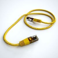
Ethernet Cable
...ethernet cable 3docean cable computer electronics ethernet internet network connected ethernet cable 3d...
3d_ocean
$4

Twitter Icon Logo
...bird computer electronics icon internet logo logos media network networkng news social socialmedia twiter twitter exact 3d model of...
3d_ocean
$12

HD WEBCAM
...cam camera com communication conference connection e-business equipment internet network rhino 3d skype streaming technology vision web web connection...
Road
3d_export
$300
City Plan 007 3D Model 3D Model
...3dexport traffic tree flat tile metro urban structure apartment road plaza office block modular detail high building skyscraper city...
3d_export
$300
City Plan 005 3D Model 3D Model
...3dexport traffic tree flat tile metro urban structure apartment road plaza office block modular detail high building skyscraper city...
3d_export
$150

Skyscraper business center 037 3D Model
...3dexport traffic tree flat tile metro urban structure apartment road plaza office block modular detail high building skyscraper city...
3d_export
$150
Skyscraper business center 045 3D Model
...3dexport traffic tree flat tile metro urban structure apartment road plaza office block modular detail high building skyscraper city...
3d_export
$99

Suzuki Jimny 2013 3D Model
...wide sierra 2013 2014 2015 2016 2-door suv crossover off-road 4x4 mini compact small japan japanese suzuki jimny 2013...
3d_export
$20

Realistic Road High Res 5980 x 4248 3D Model
...ine seamless tileable v-ray photorealistic detailed textures
realistic road high res 5980 x 4248 3d model vkmodels 47546 3dexport
3d_export
$99

Land Rover Defender 90 pickup 2011 3D Model
...90 british crossover defender england land rover landrover off road land rover defender 90 pickup 2011 3d model humster3d...
3d_export
$99

Hummer H1 wagon 2005 3D Model
...1998 1999 2000 2001 2002 2003 2004 2005 4x4 all-road hummer h1 wagon 2005 3d model humster3d 74301...
3d_export
$150
Cityscape pack vol 1 3D Model
...block new york office store shop plaza us ny road apartment structure urban metro tile flat tree traffic environment...
3d_export
$168
New Taipei City 3D Model
...model 3dexport city asia buildings building taiwan taipei street road house mall hall 3d key race bank hospital traffic...
Streets
3d_export
$15
Deutschland Architecture Window001 3D Model
...ieval mediaeval romanesque gothic doric tuscan ionic minoan
deutschland architecture window001 3d model lotusmodel 47433 3dexport
3d_export
$15

Holland Architecture Windows003 3D Model
...medieval mediaeval romanesque gothic doric tuscan ionic minoan
holland architecture windows003 3d model lotusmodel 47480 3dexport
3d_export
$60

Architecture 051 3D Model
...lege campus max street landscape commercial building medical hospital offices
architecture 051 3d model lotusmodel 47599 3dexport
3d_export
$20
Realistic Road High Res 5980 x 4248 3D Model
...ine seamless tileable v-ray photorealistic detailed textures
realistic road high res 5980 x 4248 3d model vkmodels 47546 3dexport
3d_export
$150

3d building 856 3D Model
...metropolis street block detailed definition realistic skyscraper huge collection
3d building 856 3d model kanhtart 46852 3dexport
3d_export
$15

Holland Architecture Windows001 3D Model
...medieval mediaeval romanesque gothic doric tuscan ionic minoan
holland architecture windows001 3d model lotusmodel 47478 3dexport
3d_export
$15

Holland Architecture Door003 3D Model
...re medieval mediaeval romanesque gothic doric tuscan ionic minoan
holland architecture door003 3d model lotusmodel 47475 3dexport
3d_export
$150
3d building 870 3D Model
...metropolis street block detailed definition realistic skyscraper huge collection
3d building 870 3d model kanhtart 46868 3dexport
3d_export
$150

3d building 845 3D Model
...metropolis street block detailed definition realistic skyscraper huge collection
3d building 845 3d model kanhtart 46836 3dexport
3d_export
$60
Architecture 032 3D Model
...lege campus max street landscape commercial building medical hospital offices
architecture 032 3d model lotusmodel 47578 3dexport