503 topographic 3d models found
Download or buy, then render or print from the shops or marketplaces.
3D Models below are suitable not only for printing but also for any
computer graphics like CG, VFX, Animation, or even CAD. You can print these 3d models on
your favorite 3d printer or render them with your preferred render engine.
Please note that the 3D model database is only a Search Engine. You should
visit the original websites. Most of the models can be easily imported and rendered
with Autodesk 3ds Max, Maya, Blender, C4D, and Sketchup. Check for online
3d model conversions tools for your file format.
Shown 1 of
5 pages
3d_export
$25

Topographic map
...topographic map
3dexport
simple rendering of the scene file
3ddd
free
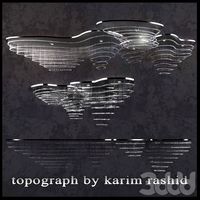
The topograph chandelier by Karim Rashid
... от карима рашида.
the topograph chandelier by karim rashid.http://www.karimrashid.com/projects#category_4/project_247
3d_export
$25
scale relief topographic world map
...ve also added the renderings both with and without texture, so that you will notice that it is done in detail.<br>enjoy it.
3d_export
$50
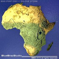
Africa 3D Model
...3dexport africa map terrain elevation satellite landscape mountain land topographic dem africa 3d model braz 21501...
3d_export
$50
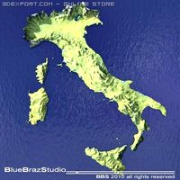
Italy 3D Model
...3dexport italy map terrain elevation satellite landscape mountain land topographic dem italy 3d model braz 21511...
3d_export
$50
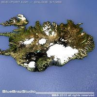
Iceland 3D Model
...3dexport iceland map terrain elevation satellite landscape mountain land topographic dem iceland 3d model braz 21509...
3d_export
$50
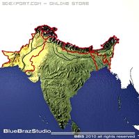
India 3D Model
...3dexport india map terrain elevation satellite landscape mountain land topographic dem india 3d model braz 21510...
3d_export
$50
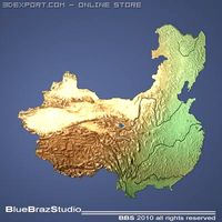
China 3D Model
...3dexport china imap terrain elevation satellite landscape mountain land topographic dem china 3d model braz 21505...
3d_export
$50
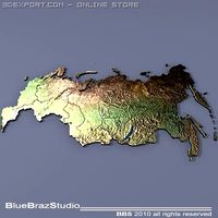
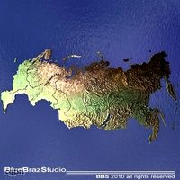
Russia 3D Model
...3dexport russia map terrain elevation satellite landscape mountain land topographic dem russia 3d model braz 21513...
3d_export
$50
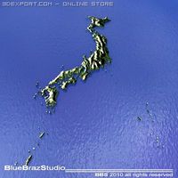
Japan 3D Model
...3dexport japan imap terrain elevation satellite landscape mountain land topographic dem japan 3d model braz 21508...
3d_export
$50
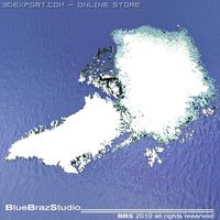
USA 3D Model
...states usa map terrain elevation satellite landscape mountain land topographic dem usa 3d model braz 21517...
3d_export
$50
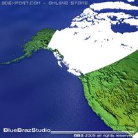
Arctic Greenland 3D Model
...arctic greenland map terrain elevation satellite landscape mountain land topographic dem arctic greenland 3d model braz 21502...
3d_export
$50

World 3D Model
...3dexport world map terrain elevation satellite landscape mountain land topographic continent globe planisphere earth world 3d model braz 21519...
3d_export
$50

Great Britain 3D Model
...great britain map terrain elevation satellite landscape mountain land topographic dem great britain 3d model braz 21130...
3d_export
$50
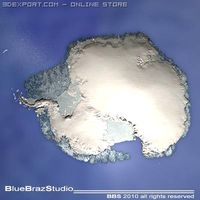
South pole 3D Model
...south pole imap terrain elevation satellite landscape mountain land topographic dem south pole 3d model braz 21514...
3d_ocean
$9
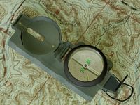
Lensatic Compass
...equipment lens magnet map military mountaineer navigation north south topographic travel voyage west 3d lensatic...
3d_export
$50
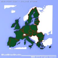
European Union 3D Model
...eu ue imap terrain elevation satellite landscape mountain land topographic dem european union 3d model braz 21506...
3d_export
$50

Sweden Norway Finland 3D Model
...norway finland map terrain elevation satellite landscape mountain land topographic dem sweden norway finland 3d model braz 21516...
3d_export
$50
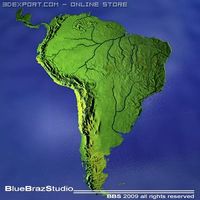
South America 3D Model
...south america map terrain elevation satellite landscape mountain land topographic dem south america 3d model braz 21515...
3d_export
$50
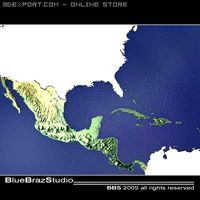
Central America 3D Model
...america south map terrain elevation satellite landscape mountain land topographic dem central america 3d model braz 21132...
3d_export
$10

Compass 3D Model
...model 3dexport compass stone magnetic earth north south magnet topographic map navigation old style antique expedition direction tools vintage...
cg_studio
$50
Russia3d model
...misc russia map terrain elevation satellite landscape mountain land topographic dem .3ds .c4d .dxf .obj - russia 3d model,...
3d_export
$50
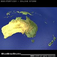
Australia and New Zealand 3D Model
...america south map terrain elevation satellite landscape mountain land topographic dem australia and new zealand 3d model braz 21503...
3d_export
$50

Middle East 3D Model
...america south map terrain elevation satellite landscape mountain land topographic dem middle east 3d model braz 21131...
cg_studio
$50

USA3d model
...states usa map terrain elevation satellite landscape mountain land topographic dem .3ds .c4d .dxf .obj - usa 3d model,...
3d_export
$17

Earth High Quality 3D Model
...relief space orbit continent ocean sea floor topography geography topographic geographic animation shaded spinning earth high quality 3d model...
3d_export
$17
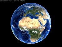
High quality earth animated 3D Model
...relief space orbit continent ocean sea floor topography geography topographic geographic animation shaded spinning high quality earth animated 3d...
evermotion
$130

SplineLand
...do it quickly, in just a few clicks your topographicl data in form of splines can become a terrain....
3d_export
$9

Earth High Quality 3D Model 3D Model
...relief space orbit continent ocean sea floor topography geography topographic geographic animation shaded spinning earth high quality 3d model...
3d_export
$17

High Quality Earth Over The Night 3D Model
...relief space orbit continent ocean sea floor topography geography topographic geographic animation shaded spinning high quality earth over the...
3d_export
$55

Compass in sand 3D Model
...compass orientation expedition north magnet scientist explorer navigation direction topographic map tool vintage old pirate maritim naval ship lost...
3d_ocean
$9

Ring Compass
...magnetic map navigation north old south stone style tools topographic vintage description: this is a stone styled compass. in...
3d_ocean
$5

Antique Compass
...magnet magnetic map navigation north old south style tools topographic vintage this is a highly detailed vintage styled compass...
cg_studio
$50

Middle East3d model
...america south map terrain elevation satellite landscape mountain land topographic dem .3ds .c4d .dxf .obj - middle east 3d...
3d_export
$25

Earth and Moon 3D Model
...relief space orbit continent ocean sea floor topography geography topographic geographic animation shaded spinning terrain landscape surface latitude longitude...
cg_studio
$79

The Grand Canyon in Arizona United States High Poly3d model
...polygon uv mapped detailed precise exact photo realistic topo topographicl landscape desert elevation model rocks canyon elevation map .vue...
3d_export
$36

Antique Compass 3D Model
...model 3dexport brass magnetic compass earth north south magnet topographic map navigation old style antique expedition explorer direction tools...
3d_export
$25

Europe Terrain C4D
...2.826 mm<br>projection: mercator<br>base: open<br>uv layer: yes (frontal)<br>textures<br>type: satellite and topographiclt;br>format: tif<br>file size: 103 mb<br>resolution: 6000*6000*24b<br>other models can be made...
thingiverse
free

Topographic Mozambique by Waynan
...topographic mozambique by waynan
thingiverse
topographic map of mozambique.
thingiverse
free

Topographic Botswana by Waynan
...topographic botswana by waynan
thingiverse
topographic map of botswana
thingiverse
free

Topographic Sudan
...o should nest together to form one large map. some trimming may be required due to the nature of the process used to create them.
thingiverse
free

Topographical pot by markfruhauf
...topographical pot by markfruhauf
thingiverse
my first topographical cactus pot planter
thingiverse
free

Topographic Namibia by Waynan
...topographic namibia by waynan
thingiverse
topographic map of namibia. see other countries under my designs.
thingiverse
free

Topographic Mauritania by Waynan
...o should nest together to form one large map. some trimming may be required due to the nature of the process used to create them.
thingiverse
free

Topographic Guinea by Waynan
...o should nest together to form one large map. some trimming may be required due to the nature of the process used to create them.
thingiverse
free

Topographic Morocco by Waynan
...o should nest together to form one large map. some trimming may be required due to the nature of the process used to create them.
thingiverse
free

Topographic Niger by Waynan
...o should nest together to form one large map. some trimming may be required due to the nature of the process used to create them.
thingiverse
free

Topographic Tunisia by Waynan
...o should nest together to form one large map. some trimming may be required due to the nature of the process used to create them.
thingiverse
free

Topographic Rwanda by Waynan
...o should nest together to form one large map. some trimming may be required due to the nature of the process used to create them.
thingiverse
free

Topographic Cameroon by Waynan
...o should nest together to form one large map. some trimming may be required due to the nature of the process used to create them.
thingiverse
free

Topographic Djibouti by Waynan
...o should nest together to form one large map. some trimming may be required due to the nature of the process used to create them.
thingiverse
free

Topographic Malawi by Waynan
...o should nest together to form one large map. some trimming may be required due to the nature of the process used to create them.
thingiverse
free

Topographic Zimbabwe by Waynan
...o should nest together to form one large map. some trimming may be required due to the nature of the process used to create them.
thingiverse
free

Topographic Angola by Waynan
...o should nest together to form one large map. some trimming may be required due to the nature of the process used to create them.
thingiverse
free

Topographic South Africa by Waynan
...topographic south africa by waynan
thingiverse
topographic map of south africa. more countries to come.
thingiverse
free

Yosemite Topographical Map by kevinbrice
...semite topographical map by kevinbrice
thingiverse
topographical map of the yosemite valley. very very high resolution. enjoy!
thingiverse
free

Topographical Moon by Ethan3D
...topographical moon by ethan3d
thingiverse
made in 3ds max
thingiverse
free

Canyon Topographical 3D Object by hpucismjrbb85
...canyon topographical 3d object by hpucismjrbb85
thingiverse
topographical region of grand canyon....
thingiverse
free

Topographic Gambia by Waynan
... used to create them.
this part is rather small, the photo attached is my first attempt at printing it which i am not happy with.
thingiverse
free

Teruel Topographic Map by Victoresge
...raphic map of teruel in spain, was made using kosmo software (http://www.opengis.es/) and demto3d extension (http://demto3d.com/)
thingiverse
free

Topographic South Sudan by Waynan
...o should nest together to form one large map. some trimming may be required due to the nature of the process used to create them.
thingiverse
free

Alcañiz Topographic Map by Victoresge
...e village of alcañiz in spain, was made using kosmo software (http://www.opengis.es/) and demto3d extension (http://demto3d.com/)
thingiverse
free
Topographic Map Generator by ATECH
...th the lines and numbers on them. the lines are called elevation lines, and the numbers correspond to the elevation of that line.
thingiverse
free

Topographical overlay by adamrw91
...em. the houses were modeled after the lidar scans and satalite images. the model was then painted to match the satalite pictures.
thingiverse
free

Topographic Map of Watkins Glen by EmilyStephenson
...ingiverse
topographic map of watkins glen, new york. designed using terrain2stl (http://jthatch.com/terrain2stl/) and tinkercad.
thingiverse
free

3D Print a Topographic Map by mfritz
...c maps in 3d. for example, pushing the contour edges together to make a steep slope, or moving them apart to make a gentle slope.
thingiverse
free

Red River NM Topographical terrain by j12sullivan
...r nm topographical terrain by j12sullivan
thingiverse
this is a topographical view of red river nm where i recently went skiing.
thingiverse
free

France topographic map by DanielChai
...lab from the following 2d map.https://en.wikipedia.org/wiki/geography_of_france#/media/file:600x600_gmt_france_topo-r1.jpg
enjoy!
thingiverse
free

China topographic map by DanielChai
...rt/tshirt/china_dem.jpg
original source: acasian, griffith university
please, no political sh*t stuff. this is purely a 3d model.
thingiverse
free

Tunisia topographic map by usinguser
... heights are exaggerated to make them stand out more. you can print with 0.2mm layer lines without bottom layers to save on time.
thingiverse
free

Luxembourg topographic map by usinguser
... heights are exaggerated to make them stand out more. you can print with 0.2mm layer lines without bottom layers to save on time.
thingiverse
free

Topographic map of Kansas with 10X vertical exaggeration
...verse
topographic map of kansas with 10x vertical exaggeration. made with touch terrain. https://touchterrain.geol.iastate.edu/
thingiverse
free

Crabtree Falls Hiking Trail Topographical Map by jayspeidell
...crabtree falls hiking trail topographical map by jayspeidell
thingiverse
crabtree falls hiking trail topographical map
thingiverse
free

Socotra Miniature Topographic Map (Correct Proportion) by AxelPilop
...a miniature topographic map (correct proportion) by axelpilop
thingiverse
socotra miniature topographic map (correct proportion)
thingiverse
free

Tasmania Miniature Topographic Map (Correct Proportion) by AxelPilop
... miniature topographic map (correct proportion) by axelpilop
thingiverse
tasmania miniature topographic map (correct proportion)
thingiverse
free

Karpathos Miniature Topographic Map (Correct Proportion) by AxelPilop
...miniature topographic map (correct proportion) by axelpilop
thingiverse
karpathos miniature topographic map (correct proportion)
thingiverse
free

Eivissa Miniature Topographic Map (Correct Proportion) by AxelPilop
...a miniature topographic map (correct proportion) by axelpilop
thingiverse
eivissa miniature topographic map (correct proportion)
thingiverse
free

Mallorca Miniature Topographic Map (Correct Proportion) by AxelPilop
... miniature topographic map (correct proportion) by axelpilop
thingiverse
mallorca miniature topographic map (correct proportion)
thingiverse
free

Lemnos Miniature Topographic Map (Correct Proportion) by AxelPilop
...os miniature topographic map (correct proportion) by axelpilop
thingiverse
lemnos miniature topographic map (correct proportion)
thingiverse
free

Samothráki Miniature Topographic Map (Correct Proportion) by AxelPilop
...iniature topographic map (correct proportion) by axelpilop
thingiverse
samothráki miniature topographic map (correct proportion)
thingiverse
free

Gökçeada Miniature Topographic Map (Correct Proportion) by AxelPilop
... miniature topographic map (correct proportion) by axelpilop
thingiverse
gökçeada miniature topographic map (correct proportion)
thingiverse
free

Corse Miniature Topographic Map (Exact Proportion) by AxelPilop
...corse miniature topographic map (exact proportion) by axelpilop
thingiverse
corse miniature topographic map (exact proportion)
sketchfab
$12

Medical Topographic System
...e to do 3d model please touch me at:cgivn.studio thanks you! - medical topographic system - buy royalty free 3d model by frezzy3d
thingiverse
free

Oahu Topographical Hawaii by kevinbrice
...n the queen's medical center for two years i was able to become very familiar with the island and wonder folk who live there.
thingiverse
free
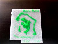
Bora Bora topographical with Braille by jaqtikkun
...bora bora topographical with braille by jaqtikkun
thingiverse
optimized for individuals with visual impairments!
thingiverse
free

Agios Efstrátios Miniature Topographic Map (Correct Proportion) by AxelPilop
...re topographic map (correct proportion) by axelpilop
thingiverse
agios efstrátios miniature topographic map (correct proportion)
thingiverse
free

Topographic Puzzle Map of the USA
...f the usa
thingiverse
a puzzle of the usa which showcases the topography as well. an interesting puzzle that will pass the time!
thingiverse
free

Michigan Topographic Maps (Au Sable River Coasters) by CraftyGirl21
...of michigan and the great lakes, and a set of 4 topographic map coasters of the au sable river (a blue ribbon fly fishing river).
thingiverse
free

Hawaii Island Topographical Map by asharkinwater
...ii island topographical map by asharkinwater
thingiverse
terrain2stl was used to create this map
http://jthatch.com/terrain2stl/
thingiverse
free

Hong Kong Topographic map by samuelnc
...hong kong topographic map by samuelnc
thingiverse
you can scale it according to your bed size
thingiverse
free

Yosemite Valley Topographic map
...he file i scaled down to fit my ender 3 as well as the original and a zaxis cut model (to not waste so much filament on the base)
thingiverse
free

Palos Verdes 3D Topographic Map by n8080
...ia. it was generated using digital elevation model (dem) data provided by the ciat-csi srtm website (http://srtm.csi.cgiar.org).
thingiverse
free

US Topographical Map by corkyzett
...
this is a remix of the original topog map. i just shaved off some of the lower parts.
https://www.thingiverse.com/thing:1524543
thingiverse
free

Upper Seattle Area Topographic Model by ckc28
...een anne and the lake union area. i used to live in magnolia and i made this map to remember places i used to visit in this area.
thingiverse
free

Ellis County Kansas Topographic map 5x vertical exaggeration
... map of ellis county kansas with 5x vertical exaggeration. made with touchterrain web app. https://touchterrain.geol.iastate.edu/
thingiverse
free

San Francisco Bay Area High Resolution Topographic Map by waleedk
...n topographic map by waleedk
thingiverse
topographic map of san francisco bay area -- high resolution -- the file is very large.
thingiverse
free

Belle-Île-en-Mer Miniature Topographic Map (Correct Proportion) by AxelPilop
...re topographic map (correct proportion) by axelpilop
thingiverse
belle-île-en-mer miniature topographic map (correct proportion)
thingiverse
free
Montana Box with Topographic Mountains by jolars
...joy :)
i printed the body without support and the top with simple supports. mine cleaned up really nice and fit together well.
thingiverse
free

Table Mountain Topographic Model/Map by TheOmelette
...table mountain topographic model/map by theomelette
thingiverse
this is a 3d model of table mountain in cape town, south africa
thingiverse
free

Topographical NES Hyrule map by videospacegames
...the colored image was taken from magicavoxel - i have not printed it and painted it yet because i am not good at painting. enjoy!
thingiverse
free

South America Topographic Map by JoshTech
...h
thingiverse
south america model for a school project. no need for supports or any special stuff. basic four level hight model.
thingiverse
free
Northfield Minnesota Topographic Map by Stefanpwinc
...ould be printed so that a narrow side is the base, this allows for low infill values and more surface detail, and less stringing.
thingiverse
free

United States Topographic Map by Stefanpwinc
...uld be printed so that the north side is the base, this allows for low infill values and more surface detail, and less stringing.
thingiverse
free

Arundel topographical model by thowe
...tom right.
it was created using terrain2stl; a web-based service that converts publicly available hgt files to useful stl files
thingiverse
free

Guildford topographical model by thowe
...the bottom
it was created using terrain2stl; a web-based service that converts publicly available hgt files to useful stl files
thingiverse
free

Planescape Outlands Topographical Map by Elfinn3
...vidual piece of that layer and i just ran out of want-to. i uploaded the obj file so you can mess with it if you are so inclined.
thingiverse
free

Grand Tetons Topographical Map by iqless
...e are two different maps of the grand tetons.
more details can be found out about how i made them at https://youtu.be/g4cx0hrejgw
thingiverse
free

Washington state topographic map by betamax
...s. stringing is a problem in the valleys, so think consider lower print temperatures or blast the finished print with a heat gun.
thingiverse
free

Denmark 3D topographic map (TEST) by Lawec
... by lawec
thingiverse
3d version of denmark's topography. made using the script here: http://www.thingiverse.com/thing:15276
thingiverse
free

Topographical Map of Ohio by jriley2
...
used illustrator to live trace each layer and save each layer as an svg
imported each layer into tinkercad and set layer heights
thingiverse
free

Mt Whitney Topographic Map by kevinbrice
...hitney
inspired from my trip, a group of six of us summited the peak from the whitney portal january 19th - january 21st of 2016.
thingiverse
free

Snowdonia topographic model by thowe
...tom right.
it was created using terrain2stl; a web-based service that converts publicly available hgt files to useful stl files
thingiverse
free

Topographical Push Pin Map
...ive (or other program that can turn topographical data into maps, like qgis)
-inkscape (or other vector program like illustrator)
thingiverse
free

Bournemouth topographical model by thowe
...s moordown
it was created using terrain2stl; a web-based service that converts publicly available hgt files to useful stl files
thingiverse
free

Kauai Topographical Map by Sleepingmarmot
... striation.
this is also printed about as small as i'd go 115mm on the longest side, it would probably do great much larger.
thingiverse
free

Topographic World Map
...then started with a version which was scaled to 40% in x and y. the whole map is split in 32 tiles, labeld as shown in the image.
thingiverse
free

Vermont Cubified Topographical Model (Generated) by Exolun
...ture is coming along, feel free to follow along on github or pull it down and give it a try.
https://github.com/exolun/oscadsharp
thingiverse
free

Topographic Montana Poker Card Capper by UWcharlie1983
...rior to assembly.
2) super glue the base to the top to trap the ballast inside.
enjoy and if you print one please post a picture!
thingiverse
free

Topographical Map of Nahalem Bay by Towellml
...only 5 min to create a ready-to-print .stl file of nehalem bay. http://jthatch.com/terrain2stl/ <------- website that i used
thingiverse
free

Philmont Topographical Model Resized by Chedwards
...the camp area. i just took the source file cut the top off the model just north of baldy and repaired the letters in the corner.