15 satellite v3 3d models found
Download or buy, then render or print from the shops or marketplaces.
3D Models below are suitable not only for printing but also for any
computer graphics like CG, VFX, Animation, or even CAD. You can print these 3d models on
your favorite 3d printer or render them with your preferred render engine.
Please note that the 3D model database is only a Search Engine. You should
visit the original websites. Most of the models can be easily imported and rendered
with Autodesk 3ds Max, Maya, Blender, C4D, and Sketchup. Check for online
3d model conversions tools for your file format.
thingiverse
free
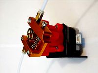
Planetary gearbox for bowden extruder by Trigubovich
...4:1 the output shaft bolt m5 screw m3x16 for satellite gear and i used self-locking nuts you can use...
thingiverse
free

SatNOGS Ground Station Antenna Rotator Covers by daten
...cover plates for the v3 version of the satnogs satellite ground station antenna rotator. includes "bottom" plate for any...
thingiverse
free

Omega Bicycle GPS Map device with color 1.44 display by mrstanlez
...mini-usb arduino connector. sd card holds data from gps satellite (date,time,latitude,longitude,altitude,speed,course) every 1 second and can viewed by http://www.gpsvisualizer.com/....
thingiverse
free

T-Piece Ø22mm PVC Pipe - V3- OPTIMISED by bathrobotics
...not suitable for use in nuclear power stations or satellite applications. basically, use this sensibly. i've used similar in...
grabcad
free

CubeSat 1U Ukr v3
...frame is designed to set the payload of the satellite (on the inner slotted guide) and fixing it in...
cg_trader
$399

Tbilisi
...updates and improvements high-resolution surface texture (1 meter resolution satellite image) 100% buildings coverage from buildings footprint polygon geometries...
cg_trader
$399

Lagos
...updates and improvements high-resolution surface texture (1 meter resolution satellite image) buildings, landuse areas, roads and railways split by...
cg_trader
$399

Batumi
...updates and improvements high-resolution surface texture (1 meter resolution satellite image) buildings, landuse areas, roads and railways split by...
cg_trader
$399

Baghdad
...updates and improvements high-resolution surface texture (1 meter resolution satellite image) buildings, landuse areas, roads and railways split by...
cg_trader
$399
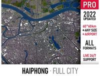
Haiphong
...updates and improvements high-resolution surface texture (1 meter resolution satellite image) buildings, landuse areas, roads and railways split by...
cg_trader
$399

Shanghai
...updates and improvements high-resolution surface texture (1 meter resolution satellite image) buildings, landuse areas, roads and railways split by...
cg_trader
$399

Nagasaki
...updates and improvements high-resolution surface texture (1 meter resolution satellite image) buildings, landuse areas, roads and railways split by...
cg_trader
$399

Sharjah
...updates and improvements high-resolution surface texture (1 meter resolution satellite image) buildings, landuse areas, roads and railways split by...
cg_trader
$399

Lusail
...updates and improvements high-resolution surface texture (1 meter resolution satellite image) buildings, landuse areas, roads and railways split by...
cg_trader
$399
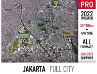
Jakarta
...to 1 meter interval) high-resolution (up to 20cm accuracy) satellite or surface texture buildings and roads placed on the...