CG Trader
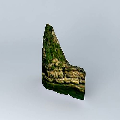
Pointe du Hoc
by CG Trader
Last crawled date: 1 year, 9 months ago
This 3D model was originally created with Sketchup 7 and then converted to all other 3D formats. Native format is .skp 3dsmax scene is 3ds Max 2016 version, rendered with Vray 3.00 Pointe du Hoc is a small step forward on the Normandy coast in the English Channel, in the Calvados. It overlooks a cliff 25 to 30 meters high with a pebble beach about ten meters wide at its feet. The tip is located in the municipality of Cricqueville-en-Bessin. It was the scene of one of the operations of the Normandy landings on June 6, 1944. Located between the beaches of Utah Beach (west) and Omaha Beach (east), the point had been fortified by the Germans and, according to Allied aerial reconnaissance was equipped with heavy artillery pieces whose scope threatened two nearby beaches. It was considered crucial for the success of the landing, the artillery pieces are made as quickly as possible offline services. beach calvados cliffs d day falaises france lapointe du hoc normandie normandy omaha utah exterior historic historic exterior
Similar models
3dwarehouse
free

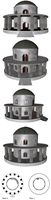
La Pointe du Hoc
...le plus rapidement possible. #beach #calvados #cliffs #dday #falaises #france #la_pointe_du_hoc #normandie #normandy #omaha #utah
thingiverse
free

Bunker_Criqueville_Pointe_du_Hoc_WWII by JMGA2S
...bunker_criqueville_pointe_du_hoc_wwii by jmga2s
thingiverse
scale 1/72, criqueville deutch bunker (pointe du hoc) omaha beach.
cg_trader
$20

Rangers at Point Du Hoc | 3D
...since they carried the assault beyond the beach, into the overlooking bluffs and outflanked the german defenses.[citation needed]
3dwarehouse
free

pointe du hoc
...lieu celebre pour avoir été un témoin de la violance du débarquement tres tot dans la journée du 6 juin #normandie #pointe_du_hoc
3dwarehouse
free

Omaha Beach
...omaha beach
3dwarehouse
omaha beach before the invasion...please rate!!! #dday #france #normandy #omaha_beach #wwii
3dwarehouse
free

Omaha Beach Dog 1
...g 1
3dwarehouse
my second attemt at omaha beach #1944 #dday #dog #france #june #normandy #omaha #omaha_beach #world_war_ii #wwii
cg_trader
free

Defensive Bunker R667 Les Moulins
...e a memorial. beach bunker concrete d day defensive france german les moulins omaha war world exterior historic historic exterior
3dwarehouse
free

Omaha beach (1942 Normandy,Stormed Beach) Before Battle
...omaha beach (1942 normandy,stormed beach) before battle
3dwarehouse
read title
3dwarehouse
free

Omaha Beach
...ehouse
my 3rd attempt at omaha beach #battle #dday #france #normandy #omaha_beach #soldier #war #world_war_2 #world_war_ii #wwii
3dwarehouse
free

D-day at Omaha Beach
...ouse
another model of omaha beach during the d-day battle on june 6, 1944 #beach #dday #france #normandy #omaha_beach #war #wwii
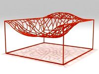
Hoc
3ddd
$1
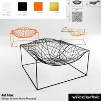
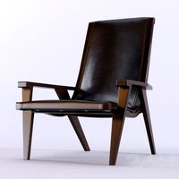
Ad-Hoc
...ad-hoc
3ddd
ad-hoc , viccarbe
ad-hoc
design jean-marie massaud 2007
viccarbe
3ddd
free
B&B Italia Poltrona J.J rocking armchair
...ash is, instead, more classic aesthetic. details designed ad hoc for each declination, from the one with the one...
3ddd
$1
B&B Italia Poltrona J.J. wire base armchair
...ash is, instead, more classic aesthetic. details designed ad hoc for each declination, from the one with the one...
3ddd
free
B&B Italia Poltrona J.J. wooden base armchair
...ash is, instead, more classic aesthetic. details designed ad hoc for each declination, from the one with the one...
3ddd
$1

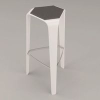
Brunner / Hoc
... барный , табурет
designer jehs & laub 2012
-max 2012+vray 2.3
-obj
3ddd
$1

Brunner / Hoc
...лиз: 800мм высота, 450мм ширина, 450мм глубинаhttp://www.brunner-group.com/en/products/products-alphabetically/hoc.html
3d_export
$5
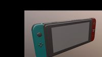
nintendo swith
...through internet connectivity, as well as local wireless ad hoc connectivity with other consoles. nintendo switch games and software...
design_connected
$16
Ad Hoc
...ad hoc
designconnected
viccarbe habitat ad hoc lounge chairs computer generated 3d model. designed by jean-marie massaud.
3d_export
$49
Brunner hoc stool 3D Model
...brunner hoc stool 3d model
3dexport
brunner hoc stool
brunner hoc stool 3d model createmodels 96507 3dexport
thingiverse
free
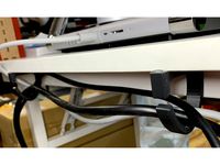
Adhesive Desk Cable Guide 01 by makersendinfo
...sharpness at the bottom. update our hot glue ad hoc solution is no solution; it failed. screw holes would...
Pointe
3ddd
$1
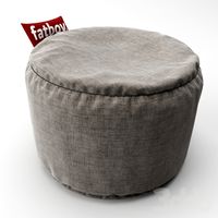
Fatboy Point puff
...fatboy point puff
3ddd
пуф
сайт производителяhttp://www.room21.no/no/artiklar/fatboy-point-puff-taupe.html
диаметр 50см
3d_ocean
$3
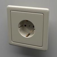
Schuko Socket
...nector power power point safety socket schuko socket wall socket
a schuko socket like the ones used in germany. colored old white
3d_ocean
$12

Classic Guitar
...texture - materials points : 633384 polygons: 615484 -created in cinema 4d studio r14 -number of main files: 3 (.c4d, .obj, .3ds)
3d_ocean
$5

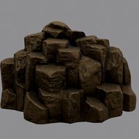
Rock_3
...ount mountain rock stone
rock_3…..............6048.polygon 6127.point. 4096*4096 texture. obj,fbx,blend format model. game ready.
3d_ocean
$5

Rock_2
...unt mountain rock stone
rock_2…...............3196.polygon 3248.point. 4096*4096 texture. obj,fbx,blend format model. game ready.
3d_ocean
$5
Rock_3
...ount mountain rock stone
rock_3…..............6048.polygon 6127.point. 4096*4096 texture. obj,fbx,blend format model. game ready.
3d_ocean
$6
Temple
...xture
-software used: cinema 4d r14 -number of main files: 3 -file formats: .c4d, .obj, .3ds -points : 2525272 -polygons: 2430949
3d_export
$19

Steel nail hammer with grip 3D Model
...steel nail hammer rip pointed-tip hard breaking grip leather pointe tool building metal head construction framing claw heavy flat...
3d_export
$20

Console Target Point Giorno CO103 0191 3D Model
...
console target point giorno co103 0191 3d model download .c4d .max .obj .fbx .ma .lwo .3ds .3dm .stl jockermax44 106708 3dexport
3d_export
$28

Bed Target Point Imbottiti 3D Model
...bottiti iron
bed target point imbottiti 3d model download .c4d .max .obj .fbx .ma .lwo .3ds .3dm .stl jockermax44 106712 3dexport