CG Trader
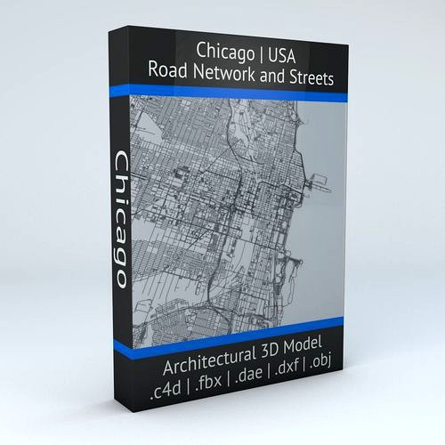
Chicago Road Network and Streets
by CG Trader
Last crawled date: 1 year, 9 months ago
this model is based on real data therefore this is a realistic road network and streets setup of Chicago, USA 2 objects included | 1. roads and streets 2. squares and plazas UV mapped with overlapping UVs the model is positioned on a flat surface (road network is on the “floor” - no elevation data included) geometry is polygonal quads and tris model is untextured and renders fast this model is fully compatible with the “Chicago Buildings and Streets” 3D model and vice versa : https://www.cgtrader.com/3d-models/exterior/cityscape/chicago-streets-and-buildings this 3D model is/can be licensed (commercial use is fine) under Creative Commons Attribution-ShareALike 2.0 (CC-BY-SA) license buildings and streets data from OpenStreetMap / www.openstreetmap.org Attribution : © OpenStreetMap contributors / http://www.openstreetmap.org/copyright POINTS/VERTS : 2377804
POLYGONS : 1766241 .c4d - native format .fbx - v7.1 .dae - v1.5 .dxf .obj chicago usa united states road network system streets infrastructure architectural map cartography city gps navigation roads squares realistic topology street architectural street city street chicago city city map city street city streets united states usa map
POLYGONS : 1766241 .c4d - native format .fbx - v7.1 .dae - v1.5 .dxf .obj chicago usa united states road network system streets infrastructure architectural map cartography city gps navigation roads squares realistic topology street architectural street city street chicago city city map city street city streets united states usa map
Similar models
cg_trader
$29

Baltimore Road Network and Streets
... realistic topology architectural street architectural street city street city map city street city streets united states usa map
cg_trader
$29

Orlando Road Network and Streets
... roads squares realistic topology street architectural street city street city map city street city streets united states usa map
cg_trader
$29
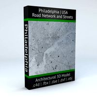
Philadelphia Road Network and Streets
... roads squares realistic topology street architectural street city street city map city street city streets united states usa map
cg_trader
$29

Detroit Road Network and Streets
... roads squares realistic topology street architectural street city street city map city street city streets united states usa map
cg_trader
$29

Miami Road Network and Streets
...alistic topological architectural street architectural street city street city map city street city streets united states usa map
cg_trader
$29

Dallas Road Network and Streets
... roads squares realistic topology street architectural street city street city map city street city streets united states usa map
cg_trader
$29

Houston Road Network and Streets
... roads squares realistic topology street architectural street city street city map city street city streets united states usa map
cg_trader
$29

Boston Road Network and Streets
...es realistic topological topology street architectural street city street city map city street city streets united states usa map
cg_trader
$29

Roswell Road Network and Streets
... roads squares realistic topology street architectural street city street city map city street city streets united states usa map
cg_trader
$29

Seattle Road Network and Streets
... roads squares realistic topology street architectural street city street city map city street city streets united states usa map
Network
3d_export
$55
Internet bar 002 3D Model
...communication server data rack computer corporate intranet office internet network servers nodes 3d electronics internet bar 002 3d model...
3d_ocean
$3

Logo Instagram
...instagram 3docean 3d max 3d model instagram logo social network this time we present a simple logo of instagram....
3ddd
$1

Pioneer network audio player N-70A-K
... usb на передней панели, обработкой многобитного сигнала, usb цап и auto sound retriever (черный)
n-70a-k
пульт ду присутствует.
3d_ocean
$12

Iphone 5 cad model
...cell communication computers detailed digital gadget iphone mobile model networkng new phone screen touch detailed cad 3d model was...
3d_ocean
$14

Apple iphone 5c cad model
...3docean apple cad cell computers digital electronic iphone mobile networkng phone radio smartphone touch touchscreen model was ceated with...
3d_ocean
$10

Social and Media Icon Set
...tube 12 modeled icons of different social and media network. created in 3d max...
3d_ocean
$21

60 Web and Social Media 3D Icons
...evernote facebook flickr forrst google icon imdb media mega network pack paypal picasa pixel reddit round sixty skype social...
3d_ocean
$16

Ethernet Cable
...ethernet cable 3docean cable computer electronics ethernet internet network connected ethernet cable 3d...
3d_ocean
$4

Twitter Icon Logo
...bird computer electronics icon internet logo logos media network networkng news social socialmedia twiter twitter exact 3d model of...
3d_ocean
$12

HD WEBCAM
...cam camera com communication conference connection e-business equipment internet network rhino 3d skype streaming technology vision web web connection...
Chicago
3ddd
$1
Картина в раме: сборник 56. Карта
...dt0022 - план города нью-йорк (new york), карта чикаго (chicago, карта бостона (boston), карта сан франциско (san francisco). time...
3ddd
$1

Busnelli / Chicago
...busnelli / chicago
3ddd
busnelli
диван фабрики "busnelli",модель "chicago",черная кожа.
archive3d
free

Sofa 3D Model
...sofa 3d model archive3d sofa couch divan sofa chicago n210812 - 3d model (*.gsm+*.3ds) for interior 3d...
3ddd
$1

Medica | Chicago
... кресло , массажное
офисное массажное кресло chicago фирмы medica
3ddd
$1

Il Loft / Chicago
... журнальный , круглый
il loft / chicago ch90. габариты 1200*1200*280.
3ddd
free
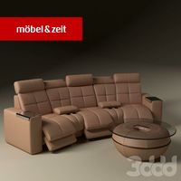
Диван и столик. Mobel&Zeit
...столик. mobel&zeit 3ddd mobel&zeit , стол , olympic диван chicago и журнальный столик olympic фирмы...
3ddd
free

Decorative set
...modern credenza"(green wood). - плитку "плитка cir chicago esagona oldchicago "; размер: 24x27,7 см. - картины и...
3ddd
$1

Декоративный набор
...набор декоративный набор состоит: тумба "rustic modern credenza". плитка "chicago south side" (bianco) с декором. размер: 20х10 см. цвет:...
3ddd
$1

Стул Ori by Bonaldo
...design 2002), присуждаемый чикагским музеем архитектуры и дизайна the chicago athenaeum. с 2007 стул ori стал частью постоянной коллекции...
3d_ocean
$2

Cloudgate
...cloudgate 3docean art chicago cloudgate landmark sculpture accurate model of anish kapoor’s iconic...
Road
3d_export
$300
City Plan 007 3D Model 3D Model
...3dexport traffic tree flat tile metro urban structure apartment road plaza office block modular detail high building skyscraper city...
3d_export
$300
City Plan 005 3D Model 3D Model
...3dexport traffic tree flat tile metro urban structure apartment road plaza office block modular detail high building skyscraper city...
3d_export
$150

Skyscraper business center 037 3D Model
...3dexport traffic tree flat tile metro urban structure apartment road plaza office block modular detail high building skyscraper city...
3d_export
$150
Skyscraper business center 045 3D Model
...3dexport traffic tree flat tile metro urban structure apartment road plaza office block modular detail high building skyscraper city...
3d_export
$99

Suzuki Jimny 2013 3D Model
...wide sierra 2013 2014 2015 2016 2-door suv crossover off-road 4x4 mini compact small japan japanese suzuki jimny 2013...
3d_export
$20

Realistic Road High Res 5980 x 4248 3D Model
...ine seamless tileable v-ray photorealistic detailed textures
realistic road high res 5980 x 4248 3d model vkmodels 47546 3dexport
3d_export
$99

Land Rover Defender 90 pickup 2011 3D Model
...90 british crossover defender england land rover landrover off road land rover defender 90 pickup 2011 3d model humster3d...
3d_export
$99

Hummer H1 wagon 2005 3D Model
...1998 1999 2000 2001 2002 2003 2004 2005 4x4 all-road hummer h1 wagon 2005 3d model humster3d 74301...
3d_export
$150
Cityscape pack vol 1 3D Model
...block new york office store shop plaza us ny road apartment structure urban metro tile flat tree traffic environment...
3d_export
$168
New Taipei City 3D Model
...model 3dexport city asia buildings building taiwan taipei street road house mall hall 3d key race bank hospital traffic...
Streets
3d_export
$15
Deutschland Architecture Window001 3D Model
...ieval mediaeval romanesque gothic doric tuscan ionic minoan
deutschland architecture window001 3d model lotusmodel 47433 3dexport
3d_export
$15

Holland Architecture Windows003 3D Model
...medieval mediaeval romanesque gothic doric tuscan ionic minoan
holland architecture windows003 3d model lotusmodel 47480 3dexport
3d_export
$60

Architecture 051 3D Model
...lege campus max street landscape commercial building medical hospital offices
architecture 051 3d model lotusmodel 47599 3dexport
3d_export
$20
Realistic Road High Res 5980 x 4248 3D Model
...ine seamless tileable v-ray photorealistic detailed textures
realistic road high res 5980 x 4248 3d model vkmodels 47546 3dexport
3d_export
$150

3d building 856 3D Model
...metropolis street block detailed definition realistic skyscraper huge collection
3d building 856 3d model kanhtart 46852 3dexport
3d_export
$15

Holland Architecture Windows001 3D Model
...medieval mediaeval romanesque gothic doric tuscan ionic minoan
holland architecture windows001 3d model lotusmodel 47478 3dexport
3d_export
$15

Holland Architecture Door003 3D Model
...re medieval mediaeval romanesque gothic doric tuscan ionic minoan
holland architecture door003 3d model lotusmodel 47475 3dexport
3d_export
$150

3d building 870 3D Model
...metropolis street block detailed definition realistic skyscraper huge collection
3d building 870 3d model kanhtart 46868 3dexport
3d_export
$150

3d building 845 3D Model
...metropolis street block detailed definition realistic skyscraper huge collection
3d building 845 3d model kanhtart 46836 3dexport
3d_export
$60
Architecture 032 3D Model
...lege campus max street landscape commercial building medical hospital offices
architecture 032 3d model lotusmodel 47578 3dexport